
Grave, Netherlands: Difference between revisions
JJMC89 bot (talk | contribs) Migrate {{Infobox settlement}} coordinates parameters to {{Coord}}, see Wikipedia:Coordinates in infoboxes |
No edit summary |
||
| (26 intermediate revisions by 19 users not shown) | |||
| Line 1: | Line 1: | ||
{{Use dmy dates|date= |
{{Use dmy dates|date=October 2023}} |
||
{{Infobox settlement |
{{Infobox settlement |
||
<!-- See Template:Infobox settlement for additional fields and descriptions --> |
<!-- See Template:Infobox settlement for additional fields and descriptions --> |
||
<!-- Name and transliteration --> |
<!-- Name and transliteration --> |
||
| name = Grave |
| name = Grave |
||
| settlement_type = |
| settlement_type = City and former municipality |
||
<!-- Images, nickname, motto --> |
<!-- Images, nickname, motto --> |
||
| image_skyline = Grave skyline maaskade.jpg |
| image_skyline = Grave skyline maaskade.jpg |
||
| Line 18: | Line 18: | ||
| image_map = Map - NL - Municipality code 0786 (2009).svg |
| image_map = Map - NL - Municipality code 0786 (2009).svg |
||
| map_alt = Highlighted position of Grave in a municipal map of North Brabant |
| map_alt = Highlighted position of Grave in a municipal map of North Brabant |
||
| map_caption = Location in North Brabant |
| map_caption = Location of the former municipality of Grave in North Brabant |
||
| pushpin_map = Netherlands North Brabant#Netherlands |
|||
| pushpin_label_position = |
|||
| pushpin_mapsize = 250 |
|||
| pushpin_map_caption = Location in the province of North Brabant in the Netherlands |
|||
| coordinates = {{coord|51|46|N|5|44|E|region:NL|display=inline,title}} |
| coordinates = {{coord|51|46|N|5|44|E|region:NL|display=inline,title}} |
||
| coordinates_footnotes = |
| coordinates_footnotes = |
||
| Line 25: | Line 29: | ||
| subdivision_type1 = [[Provinces of the Netherlands|Province]] |
| subdivision_type1 = [[Provinces of the Netherlands|Province]] |
||
| subdivision_name1 = [[North Brabant]] |
| subdivision_name1 = [[North Brabant]] |
||
| subdivision_type2 = [[Municipalities of the Netherlands|Municipality]] |
|||
| government_footnotes = <ref name="mayor_now">{{cite web |
|||
| subdivision_name2 = [[Land van Cuijk]] |
|||
|url = http://www.grave.nl/internet/college_228/ |
|||
|title = College |
|||
|trans_title = Board |
|||
|language = Dutch |
|||
|author = |
|||
|date = |
|||
|work = |
|||
|publisher = Gemeente Grave |
|||
|accessdate = 28 May 2014}}</ref> |
|||
| governing_body = [[Municipal council (Netherlands)|Municipal council]] |
|||
| leader_party = [[People's Party for Freedom and Democracy|VVD]] |
|||
| leader_title = [[Burgemeester|Mayor]] |
|||
| leader_name = [[Lex Roolvink]] |
|||
<!-- Geographic information --> |
<!-- Geographic information --> |
||
| unit_pref = Metric |
| unit_pref = Metric |
||
<!-- ALL fields with measurements have automatic unit conversion --> |
<!-- ALL fields with measurements have automatic unit conversion --> |
||
<!-- for references: use <ref> tags --> |
<!-- for references: use <ref> tags --> |
||
| area_footnotes = <ref |
| area_footnotes = <ref name="stat"/> |
||
<!-- square kilometers --> |
<!-- square kilometers --> |
||
| area_total_km2 = |
| area_total_km2 = 3.24 |
||
| area_land_km2 = |
| area_land_km2 = |
||
| area_water_km2 = |
| area_water_km2 = |
||
| elevation_footnotes = <ref name="AHN">{{cite web |
| elevation_footnotes = <ref name="AHN">{{cite web |
||
|url |
|url=http://www.ahn.nl/postcodetool |
||
|title |
|title=Postcodetool for 5361CV |
||
| |
|language=nl |
||
| ⚫ | |||
|language = Dutch |
|||
| ⚫ | |||
|author = <!--Staff writer(s); no by-line.--> |
|||
|date |
|access-date=28 May 2014 |
||
|url-status=dead |
|||
| ⚫ | |||
|archive-url=https://web.archive.org/web/20130921053543/http://www.ahn.nl/postcodetool |
|||
| ⚫ | |||
|archive-date=21 September 2013 |
|||
|accessdate = 28 May 2014}}</ref> |
|||
}}</ref> |
|||
| elevation_m = 10 |
| elevation_m = 10 |
||
| elevation_max_footnotes = <!-- for references: use <ref> tags --> |
| elevation_max_footnotes = <!-- for references: use <ref> tags --> |
||
| Line 64: | Line 57: | ||
| elevation_min_m = |
| elevation_min_m = |
||
<!-- Population, demographics --> |
<!-- Population, demographics --> |
||
| population_footnotes = <ref name="stat">{{cite web |url=https://www.cbs.nl/-/media/_excel/2021/48/kwb-2021.xls |title=Kerncijfers wijken en buurten 2021 |website=Central Bureau of Statistics |access-date=17 April 2022}}</ref> |
|||
| population_footnotes = <ref>{{Dutch municipality population|dataref}}</ref> |
|||
| population_total = |
| population_total = 8,580 |
||
| population_as_of = |
| population_as_of = 2021 |
||
| population_density_km2 = |
| population_density_km2 = auto <!-- For automatic calculation: auto--> |
||
| population_demonym = |
| population_demonym = |
||
<!-- Other information --> |
<!-- Other information --> |
||
| Line 75: | Line 68: | ||
| utc_offset_DST = +2 |
| utc_offset_DST = +2 |
||
| postal_code_type = [[Postal codes in the Netherlands|Postcode]] |
| postal_code_type = [[Postal codes in the Netherlands|Postcode]] |
||
| postal_code = |
| postal_code = 5360–5361<ref name="stat"/> |
||
| area_code_type = [[Telephone numbers in the Netherlands|Area code]] |
| area_code_type = [[Telephone numbers in the Netherlands|Area code]] |
||
| area_code = 0486 |
| area_code = 0486 |
||
| Line 81: | Line 74: | ||
| footnotes = |
| footnotes = |
||
}} |
}} |
||
| ⚫ | |||
| ⚫ | '''Grave''' ({{IPA-nl|ˈɣraːvə|lang|196 Grave.ogg}}; formerly ''De Graaf'') is a city and former municipality in the Dutch province of [[North Brabant]]. The former municipality had a population of {{formatnum:{{Dutch municipality population|Grave}}}} in {{YEAR|{{Dutch municipality population|popbaseyear}}}}. Grave is a member of the Dutch Association of Fortified Cities. |
||
| ⚫ | |||
| ⚫ | '''Grave''' ({{ |
||
The municipality |
The former municipality included the following towns : Grave (capital), [[Velp, North Brabant|Velp]], [[Escharen]] and [[Gassel]]. |
||
Grave, [[Boxmeer]], [[Cuijk (municipality)|Cuijk]], [[Mill en Sint Hubert]], and [[Sint Anthonis]] merged into the new municipality of [[Land van Cuijk]] on 1 January 2022. |
|||
== History == |
== History == |
||
{{See also|Siege of Grave (1586)}} |
{{See also|Siege of Grave (1586)}} |
||
{{See also|Siege of Grave (1602)}} |
{{See also|Siege of Grave (1602)}} |
||
{{See also|Siege of Grave (1674)}} |
|||
| ⚫ | |||
| ⚫ | This changed in 1942. Then there was a reclassification place where the municipality Grave was expanded with the previously independent municipalities [[Velp, North Brabant|Velp]] and [[Escharen]]. Moreover, in 1994 the neighboring municipality of [[Beers (Netherlands)|Beers]] was abolished and a part thereof, the parish [[Gassel]], was also added to the municipality Grave. |
||
Grave received [[City rights in the Netherlands|city rights]] in 1233. |
Grave received [[City rights in the Netherlands|city rights]] in 1233. |
||
| ⚫ | |||
| ⚫ | This changed in 1942. Then there was a reclassification place where the municipality Grave was expanded with the previously independent municipalities [[Velp, North Brabant|Velp]] and [[Escharen]]. Moreover, in 1994 the neighboring municipality of [[Beers (Netherlands)|Beers]] was abolished and a part thereof, the parish [[Gassel]], was also added to the municipality Grave. |
||
== Popular attractions == |
== Popular attractions == |
||
Near to Grave lies a bridge, now called [[John S. Thompsonbrug]], built in 1929. It is the northern connection to [[Gelderland]], spanning the river [[Meuse|Maas]]. The bridge was one of the key strategic points in [[Operation Market Garden]]; the city was liberated at 17 September 1944, |
Near to Grave lies a bridge, now called [[John S. Thompsonbrug]], built in 1929. It is the northern connection to [[Gelderland]], spanning the river [[Meuse|Maas]]. The bridge was one of the key strategic points in [[Operation Market Garden]]; the city was liberated at 17 September 1944, suffering very little damage. The bridge was named in 2004 after Lieutenant [[Jocko Thompson|John S. Thompson]] of the [[Army of the United States|US Army]]'s [[82nd Airborne Division]], who commanded the platoon of the [[82nd Airborne Division]] that captured the bridge. |
||
The Hampoort is the old entrance to the city, and it is still largely intact and can be visited. |
The Hampoort is the old entrance to the city, and it is still largely intact and can be visited. |
||
== |
== Notable people == |
||
[[File:MaryofGuelders.jpg|140px|thumb|Mary of Guelders]] |
|||
| ⚫ | |||
| ⚫ | |||
=== Nobility === |
|||
| ⚫ | |||
* [[Adolf, Duke of Guelders]] (1438 in Grave – 1477) [[Duke of Guelders]] & [[Count of Zutphen]] 1465–1471 |
|||
* [[Charles II, Duke of Guelders]] (1467 in Grave – 1538) member of the [[House of Egmond]] who ruled as [[Duke of Guelders]] and [[Count of Zutphen]] from 1492 to 1538 |
|||
| ⚫ | |||
* [[Louise van der Nooth]] (1630s in Grave – 1654) a maid of honour and favorite of [[Queen Christina of Sweden]] |
|||
=== and === |
|||
* [[Johann Weyer]] (1515 in Grave – 1588) Dutch physician, occultist and demonologist, disciple and follower of [[Heinrich Cornelius Agrippa]] |
|||
* [[Charles de Thierry]] (1793 in Grave – 1864) an adventurer in New Zealand |
|||
* [[Jan Pieter van Suchtelen]] (1751 in Grave – 1836) general in the Russian army during the [[Russo-Swedish War (1808–1809)]] |
|||
* [[Johan Stein]] (1871 in Grave – 1951) Dutch astronomer and a member of the [[Society of Jesus]] |
|||
== Images == |
== Images == |
||
<gallery> |
<gallery> |
||
| ⚫ | |||
Image:Grave, straatzicht bij Oranjehotel foto1 2010-04-10 11.02. |
Image:Grave, straatzicht Brugstraat 2-10 bij Oranjehotel foto1 2010-04-10 11.02.jpg|Houses in centre |
||
Image:Grave vistrap inlaat scheepswerf.jpg|[[Fish ladder]] and shipyard |
Image:Grave vistrap inlaat scheepswerf.jpg|[[Fish ladder]] and shipyard |
||
Image:Grave canal lock.jpg|Canal lock |
Image:Grave canal lock.jpg|Canal lock |
||
| ⚫ | |||
</gallery> |
</gallery> |
||
| Line 117: | Line 126: | ||
== References == |
== References == |
||
{{Reflist |
{{Reflist}} |
||
== External links == |
== External links == |
||
| Line 133: | Line 142: | ||
| Northwest = [[Oss]] |
| Northwest = [[Oss]] |
||
}} |
}} |
||
{{Dutch municipality Land van Cuijk}} |
|||
{{North Brabant Province}} |
|||
{{Authority control}} |
{{Authority control}} |
||
[[Category: |
[[Category:Cities in the Netherlands]] |
||
[[Category:Populated places in North Brabant]] |
[[Category:Populated places in North Brabant]] |
||
[[Category: |
[[Category:Former municipalities of North Brabant]] |
||
[[Category: |
[[Category:Municipalities of the Netherlands disestablished in 2022]] |
||
[[Category:Geography of Land van Cuijk]] |
|||
[[Category:Rivers with fish ladders]] |
|||
Revision as of 12:31, 23 July 2024
Grave | |
|---|---|
City and former municipality | |
 Grave town centre | |
 Flag  Coat of arms | |
.svg) Location of the former municipality of Grave in North Brabant | |
 Grave Location in the province of North Brabant in the Netherlands  Grave Grave (Netherlands) | |
| Coordinates: 51°46′N 5°44′E / 51.767°N 5.733°E | |
| Country | Netherlands |
| Province | North Brabant |
| Municipality | Land van Cuijk |
| Area | |
| • Total | 3.24 km2 (1.25 sq mi) |
| Elevation | 10 m (30 ft) |
| Population (2021)[1] | |
| • Total | 8,580 |
| • Density | 2,600/km2 (6,900/sq mi) |
| Time zone | UTC+1 (CET) |
| • Summer (DST) | UTC+2 (CEST) |
| Postcode | 5360–5361[1] |
| Area code | 0486 |
| Website | www |

Grave (Dutch: [ˈɣraːvə] ; formerly De Graaf) is a city and former municipality in the Dutch province of North Brabant. The former municipality had a population of 12,486 in 2021. Grave is a member of the Dutch Association of Fortified Cities.
The former municipality included the following towns : Grave (capital), Velp, Escharen and Gassel.
Grave, Boxmeer, Cuijk, Mill en Sint Hubert, and Sint Anthonis merged into the new municipality of Land van Cuijk on 1 January 2022.
History
Grave received city rights in 1233.
The former municipality of Grave was formed in the Napoleonic era (1810) and coincided with the fortified Grave and immediate surroundings. The history of the town was thus linked to that of the place.
This changed in 1942. Then there was a reclassification place where the municipality Grave was expanded with the previously independent municipalities Velp and Escharen. Moreover, in 1994 the neighboring municipality of Beers was abolished and a part thereof, the parish Gassel, was also added to the municipality Grave.
Popular attractions
Near to Grave lies a bridge, now called John S. Thompsonbrug, built in 1929. It is the northern connection to Gelderland, spanning the river Maas. The bridge was one of the key strategic points in Operation Market Garden; the city was liberated at 17 September 1944, suffering very little damage. The bridge was named in 2004 after Lieutenant John S. Thompson of the US Army's 82nd Airborne Division, who commanded the platoon of the 82nd Airborne Division that captured the bridge.
The Hampoort is the old entrance to the city, and it is still largely intact and can be visited.
Notable people

Nobility
- Mary of Guelders (c. 1434 in Grave – 1463), the queen consort of Scotland as the wife of King James II of Scotland, served as regent of Scotland from 1460 to 1463
- Adolf, Duke of Guelders (1438 in Grave – 1477) Duke of Guelders & Count of Zutphen 1465–1471
- Charles II, Duke of Guelders (1467 in Grave – 1538) member of the House of Egmond who ruled as Duke of Guelders and Count of Zutphen from 1492 to 1538
- Anna van Egmont (1533 in Grave – 1558) a wealthy Dutch heiress, the first wife of William the Silent, Prince of Orange
- Louise van der Nooth (1630s in Grave – 1654) a maid of honour and favorite of Queen Christina of Sweden
and
- Johann Weyer (1515 in Grave – 1588) Dutch physician, occultist and demonologist, disciple and follower of Heinrich Cornelius Agrippa
- Charles de Thierry (1793 in Grave – 1864) an adventurer in New Zealand
- Jan Pieter van Suchtelen (1751 in Grave – 1836) general in the Russian army during the Russo-Swedish War (1808–1809)
- Johan Stein (1871 in Grave – 1951) Dutch astronomer and a member of the Society of Jesus
Images
-
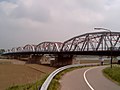 Bridge: John S. Thompsonbrug
 -
 Houses in centre
 -
 Fish ladder and shipyard
 -
 Canal lock


See also
- Apostolic Vicariate of Grave–Nijmegen, former Catholic pre-diocesan jurisdiction
References
- ^ a b c "Kerncijfers wijken en buurten 2021". Central Bureau of Statistics. Retrieved 17 April 2022.
- ^ "Postcodetool for 5361CV". Actueel Hoogtebestand Nederland (in Dutch). Het Waterschapshuis. Archived from the original on 21 September 2013. Retrieved 28 May 2014.
External links
 Media related to Grave, Netherlands at Wikimedia Commons
- Official website
Places adjacent to Grave, Netherlands | |
|---|---|
| International | |
|---|---|
| National | |
| Geographic | |