
Great Nunatak: Difference between revisions
Ron Clausen (talk | contribs) →Gallery: better photo |
Gamapamani (talk | contribs) m fix unpaired tags |
||
| (4 intermediate revisions by 2 users not shown) | |||
| Line 14: | Line 14: | ||
| location = [[Chugach National Forest]]<br />[[Valdez-Cordova Borough, Alaska|Valdez-Cordova Borough]]<br />[[Alaska]], [[United States]] |
| location = [[Chugach National Forest]]<br />[[Valdez-Cordova Borough, Alaska|Valdez-Cordova Borough]]<br />[[Alaska]], [[United States]] |
||
| map = USA Alaska |
| map = USA Alaska |
||
| range_coordinates = |
|||
| map_caption = Location of Great Nunatak in Alaska |
| map_caption = Location of Great Nunatak in Alaska |
||
| label_position = left |
| label_position = left |
||
| Line 25: | Line 24: | ||
}} |
}} |
||
'''Great Nunatak''' is a {{convert|3652|ft|m|0|adj=on}} elevation summit located {{convert|21|mi|km|0|abbr=on}} west of [[Valdez, Alaska|Valdez]] in the [[Chugach Mountains]] of the [[U.S. state]] of [[Alaska]]. This remote mountain is situated near the terminus of the [[Columbia Glacier (Alaska)|Columbia Glacier]], {{convert|11|mi|km|0|abbr=on}} southeast of [[Columbia Peak (Alaska)|Columbia Peak]], on land managed by [[Chugach National Forest]]. This 2.2-mile long feature has a secondary summit, elevation 3,412 ft.<ref name="listsofjohn">{{cite web|url=https://listsofjohn.com/peak/158831|title=Great Nunatak - 3,647' Alaska|website=listsofjohn.com|accessdate=2020-03-16}}</ref> Great Nunatak traces its name to [[Grove Karl Gilbert]], a geologist with the [[United States Geological Survey]] who was part of the 1899 [[Harriman Alaska expedition]] that explored this area. He believed it to be the largest [[nunatak]] in Alaska when he casually referred to it as ''"the great nunatak"'' in a 1902 publication. The mountain's |
'''Great Nunatak''' is a {{convert|3652|ft|m|0|adj=on}} elevation summit located {{convert|21|mi|km|0|abbr=on}} west of [[Valdez, Alaska|Valdez]] in the [[Chugach Mountains]] of the [[U.S. state]] of [[Alaska]]. This remote mountain is situated near the terminus of the [[Columbia Glacier (Alaska)|Columbia Glacier]], {{convert|11|mi|km|0|abbr=on}} southeast of [[Columbia Peak (Alaska)|Columbia Peak]], on land managed by [[Chugach National Forest]]. This 2.2-mile long feature has a secondary summit, elevation 3,412 ft.<ref name="listsofjohn">{{cite web|url=https://listsofjohn.com/peak/158831|title=Great Nunatak - 3,647' Alaska|website=listsofjohn.com|accessdate=2020-03-16}}</ref> Great Nunatak traces its name to [[Grove Karl Gilbert]], a geologist with the [[United States Geological Survey]] who was part of the 1899 [[Harriman Alaska expedition]] that explored this area. He believed it to be the largest [[nunatak]] in Alaska when he casually referred to it as ''"the great nunatak"'' in a 1902 publication. The mountain's toponym was officially adopted in 1975 by the [[U.S. Board on Geographic Names]].<ref name="gnis">{{cite gnis|id=1402940|name=Great Nunatak|accessdate=2020-03-16}}</ref> While the name remains, its status as a nunatak is obsolete because glacier lobes that once barely touched, now no longer completely encircle this landform as the Columbia Glacier retreats, and tidewater of Columbia Bay replaces the ice on the north and west aspects of the mountain.<ref>Pfeffer, W. Tad "''The Opening of a New Landscape: Columbia Glacier at Mid-Retreat''", 2007, {{ISBN|978-0-87590-729-1}}</ref> |
||
==Climate== |
==Climate== |
||
Based on the [[Köppen climate classification]], Great Nunatak is located in a [[subarctic climate]] zone with long, cold, snowy winters, and mild summers.<ref name=Peel>{{cite journal | author = Peel, M. C. |author2=Finlayson, B. L. |author3=McMahon, T. A. |
Based on the [[Köppen climate classification]], Great Nunatak is located in a [[subarctic climate]] zone with long, cold, snowy winters, and mild summers.<ref name=Peel>{{cite journal | author = Peel, M. C. |author2=Finlayson, B. L. |author3=McMahon, T. A. | year = 2007 | title = Updated world map of the Köppen−Geiger climate classification | journal = Hydrol. Earth Syst. Sci. | volume = 11 | issn = 1027-5606}}</ref> Weather systems coming off the [[Gulf of Alaska]] are forced upwards by the Chugach Mountains ([[orographic lift]]), causing heavy precipitation in the form of rainfall and snowfall. Winter temperatures can drop below 0 °F with wind chill factors below −10 °F. This climate supports the Columbia Glacier near this mountain. The months May through June offer the most favorable weather for climbing or viewing. |
||
==See also== |
==See also== |
||
| Line 40: | Line 39: | ||
==Gallery== |
==Gallery== |
||
<div style="max-width: 460px;"> |
|||
<gallery mode="packed-hover" heights="220"> |
|||
<gallery mode=slideshow> |
|||
File:Great Nunatak north aspect.jpg|North aspect in 2006 |
File:Great Nunatak north aspect.jpg|North aspect in 2006 |
||
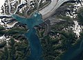
File:Columbia Bay (Alaska) by Sentinel-2.jpg|Satellite view in 2018 showing tidewater on the north and west sides of Great Nunatak (in bullseye) |
File:Columbia Bay (Alaska) by Sentinel-2.jpg|Satellite view in 2018 showing tidewater on the north and west sides of Great Nunatak (in bullseye) |
||
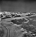
File:Columbia Glacier, Valley Glacier, August 25, 1969 (GLACIERS 1047).jpg|Great Nunatak in 1969 |
File:Columbia Glacier, Valley Glacier, August 25, 1969 (GLACIERS 1047).jpg|Great Nunatak in 1969 |
||
Columbia Glacier and Great Nunatak.jpg|Great Nunatak in lower half of frame surrounded by Columbia Glacier in 1966 |
Columbia Glacier and Great Nunatak.jpg|Great Nunatak in lower half of frame surrounded by Columbia Glacier in 1966 |
||
File:Columbia Peak bullseye.jpg|Great Nunatak in lower right corner, 1993. ([[Columbia Peak (Alaska)|Columbia Peak]] centered) |
File:Columbia Peak bullseye.jpg|Great Nunatak in lower right corner, 1993. ([[Columbia Peak (Alaska)|Columbia Peak]] centered) |
||
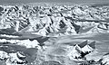
File:Icebergs and Great Nunatak.jpg|South aspect |
|||
</gallery> |
</gallery> |
||
</div> |
|||
==External links== |
==External links== |
||
* |
* [https://www.yr.no/en/forecast/daily-table/2-5863356/United%20States/Alaska/Chugach/Great%20Nunatak Weather Forecast] |
||
* [https://forecast.weather.gov/MapClick.php?lon=-147.016211&lat=61.107363#.Xm_aUW5Fycy National Weather Service Forecast] |
|||
[[Category:Mountains of Alaska]] |
[[Category:Mountains of Alaska]] |
||
[[Category:Landforms of |
[[Category:Landforms of Chugach Census Area, Alaska]] |
||
[[Category:North American 1000 m summits]] |
|||
Latest revision as of 03:55, 29 June 2024
| Great Nunatak | |
|---|---|
 Aerial view from the south in 1934 | |
| Highest point | |
| Elevation | 3,652 ft (1,113 m)[1] |
| Prominence | 1,952 ft (595 m)[1] |
| Isolation | 3.33 mi (5.36 km)[1] |
| Coordinates | 61°06′27″N 147°00′58″W / 61.10750°N 147.01611°W[1] |
| Geography | |
 Great Nunatak Location of Great Nunatak in Alaska | |
| Location | Chugach National Forest Valdez-Cordova Borough Alaska, United States |
| Parent range | Chugach Mountains |
| Topo map | USGS Anchorage A-1 |
Great Nunatak is a 3,652-foot (1,113 m) elevation summit located 21 mi (34 km) west of Valdez in the Chugach Mountains of the U.S. state of Alaska. This remote mountain is situated near the terminus of the Columbia Glacier, 11 mi (18 km) southeast of Columbia Peak, on land managed by Chugach National Forest. This 2.2-mile long feature has a secondary summit, elevation 3,412 ft.[2] Great Nunatak traces its name to Grove Karl Gilbert, a geologist with the United States Geological Survey who was part of the 1899 Harriman Alaska expedition that explored this area. He believed it to be the largest nunatak in Alaska when he casually referred to it as "the great nunatak" in a 1902 publication. The mountain's toponym was officially adopted in 1975 by the U.S. Board on Geographic Names.[3] While the name remains, its status as a nunatak is obsolete because glacier lobes that once barely touched, now no longer completely encircle this landform as the Columbia Glacier retreats, and tidewater of Columbia Bay replaces the ice on the north and west aspects of the mountain.[4]
Climate
[edit]Based on the Köppen climate classification, Great Nunatak is located in a subarctic climate zone with long, cold, snowy winters, and mild summers.[5] Weather systems coming off the Gulf of Alaska are forced upwards by the Chugach Mountains (orographic lift), causing heavy precipitation in the form of rainfall and snowfall. Winter temperatures can drop below 0 °F with wind chill factors below −10 °F. This climate supports the Columbia Glacier near this mountain. The months May through June offer the most favorable weather for climbing or viewing.
See also
[edit]References
[edit]- ^ a b c d "Great Nunatak, Alaska". Peakbagger.com. Retrieved 2020-03-16.
- ^ "Great Nunatak - 3,647' Alaska". listsofjohn.com. Retrieved 2020-03-16.
- ^ "Great Nunatak". Geographic Names Information System. United States Geological Survey, United States Department of the Interior. Retrieved 2020-03-16.
- ^ Pfeffer, W. Tad "The Opening of a New Landscape: Columbia Glacier at Mid-Retreat", 2007, ISBN 978-0-87590-729-1
- ^ Peel, M. C.; Finlayson, B. L.; McMahon, T. A. (2007). "Updated world map of the Köppen−Geiger climate classification". Hydrol. Earth Syst. Sci. 11. ISSN 1027-5606.
Gallery
[edit]-
 North aspect in 2006
 -
 Satellite view in 2018 showing tidewater on the north and west sides of Great Nunatak (in bullseye)
 -
 Great Nunatak in 1969
 -
 Great Nunatak in lower half of frame surrounded by Columbia Glacier in 1966
 -
 Great Nunatak in lower right corner, 1993. (Columbia Peak centered)
 -
 South aspect

_by_Sentinel-2.jpg)
.jpg)


