
Galician Massif: Difference between revisions
mNo edit summary |
mNo edit summary |
||
| (30 intermediate revisions by 22 users not shown) | |||
| Line 1: | Line 1: | ||
{{Infobox mountain |
{{Infobox mountain |
||
|name=Galician Massif |
| name=Galician Massif |
||
|other_name= |
| other_name=Macizo Galaico<br/>Macizo Galaico-Leonés |
||
| photo=Plegamiento de Campodola Leixazós en la Sierra do Caurel.JPG |
|||
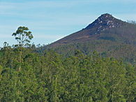
|photo=Manzaneda invierno.jpg |
|||
| ⚫ | |||
|photo_caption=View of [[Cabeza de Manzaneda]] in winter |
|||
| ⚫ | |||
| ⚫ | |||
| coordinates= {{coord|42|14|33|N|6|47|45|W|type:mountain_scale:100000|format=dms|display=inline}} |
|||
| ⚫ | |||
| country= [[Spain]] |
|||
| lat_d = 42| lat_m = 14| lat_s = 33| lat_NS = N |
|||
| ⚫ | |||
| long_d = 6| long_m = 47| long_s =45 | long_EW = W |
|||
| subdivision1= {{enum|[[Galicia (Spain)|Galicia]]|[[Castile and León]]}} |
|||
|country=[[Spain]]|country1=|country2=|country3= |
|||
| geology= {{enum|[[Schist]]|[[gneiss]]|[[granite]]}} |
|||
|country4=|country5=|country6=|country7= |
|||
| age= [[Paleozoic]] |
|||
| ⚫ | |||
| orogeny=[[Variscan orogeny]] |
|||
|region=[[Galicia (Spain)|Galicia]] |
|||
| area_km2= |
|||
|region1=[[Castile and León]] |
|||
| length_km= |
|||
|region2= |
|||
| ⚫ | |||
|region3= |
|||
| width_km= |
|||
|region4= |
|||
| ⚫ | |||
|region5= |
|||
| range_coordinates= {{coord|42|30|N|8|6|W|type:mountain_scale:300000|format=dms|display=inline,title}} |
|||
|border=| border1= |
|||
| ⚫ | |||
|geology=[[Schist]] | geology1=[[gneiss]]| geology2=[[granite]]| geology3=[[slate]]| period=[[Paleozoic]] | orogeny=[[Variscan orogeny]] |
|||
| ⚫ | |||
| ⚫ | |||
| range_lat_d=42|range_lat_m=30|range_lat_s=|range_lat_NS=N |
|||
| range_long_d=8|range_long_m=6|range_long_s=|range_long_EW=W |
|||
| ⚫ | |||
| map_caption=Topographic map of Galicia |
| map_caption=Topographic map of Galicia |
||
}} |
}} |
||
The '''Galician Massif''' |
The '''Galician Massif''' or '''Galician-Leonese Massif''' ({{lang-es|Macizo Galaico}}, also known as ''Macizo Galaico-Leonés'') is a system of [[mountain range]]s in the northwestern corner of the [[Iberian Peninsula]]. It is located in [[Galicia (Spain)|Galicia]] with its southeastern end reaching into the provinces of [[Zamora Province|Zamora]] and [[León Province|León]] of [[Castile and León]]. Its highest point is [[Pena Trevinca]] at {{convert|2127|m|ft}} . Another important peak is [[Cabeza de Manzaneda]] (1,781 m). |
||
In [[Galician culture|traditional local folklore]] the forests of the Galician System are said to be inhabited by a variety of [[elves]], [[fairies]], [[ghost]]s and [[witch]]es ''(meigas)''. |
In [[Galician culture|traditional local folklore]] the forests of the Galician System are said to be inhabited by a variety of [[elves]], [[fairies]], [[ghost]]s, the [[Santa Compaña]], the [[Nuberu|Nubeiro]] and [[witch]]es ''(meigas)''. |
||
== |
==Geology== |
||
[[Geomorphologically]] the Galician Massif is a northwestern prolongation of the [[Meseta Central]], the inner Iberian plateau and has great affinity with the geology of the [[Trás-os-Montes (region)|Tras os Montes]] Portuguese region, so that it is considered as a whole under the name 'Galicia-Trás-os-Montes Zone'.<ref>[http://digital.csic.es/handle/10261/30737 Silurian graptolite biostratigraphy of the Galicia - Tras-os-Montes Zone (Spain and Portugal)]</ref> It is composed of [[Paleozoic]] materials ([[granite]]) with [[metamorphic rock]]s such as [[gneiss]], [[slate]] and [[schist]] in the center and west, which were subject to [[Alpine folding]]. Its eastern end merges with the [[Cantabrian Mountains]].<ref>Wes Gibbons & Teresa Moreno, ''The geology of Spain''. Geological Society of London, 2003</ref> |
[[Geomorphologically]] the Galician Massif is a northwestern prolongation of the [[Meseta Central]], the inner Iberian plateau and has great affinity with the geology of the [[Trás-os-Montes (region)|Tras os Montes]] Portuguese region, so that it is considered as a whole under the name 'Galicia-Trás-os-Montes Zone'.<ref>[http://digital.csic.es/handle/10261/30737 Silurian graptolite biostratigraphy of the Galicia - Tras-os-Montes Zone (Spain and Portugal)]</ref> It is composed of [[Paleozoic]] materials ([[granite]]) with [[metamorphic rock]]s such as [[gneiss]], [[slate]] and [[schist]] in the center and west, which were subject to [[Alpine folding]]. Its eastern end merges with the [[Cantabrian Mountains]].<ref>Wes Gibbons & Teresa Moreno, ''The geology of Spain''. Geological Society of London, 2003</ref> |
||
The [[terrain|relief]] of the system, with an average height of 500 |
The [[terrain|relief]] of the system, with an average height of {{convert|500|m|ft}}, is relatively smooth compared with other Iberian ranges. It is however very complex, having no defined structural alignment owing to the heavy [[fluvial erosion]] that has fragmented the terrain. |
||
Generally the system includes mountains that are rounded in shape, often topped by small rocky outcrops, as well as [[Horst (geology)|horsts]], basins and [[Fault (geology)|faults]], roughly aligned in a N-S direction. |
Generally the system includes mountains that are rounded in shape, often topped by small rocky outcrops, as well as [[Horst (geology)|horsts]], basins and [[Fault (geology)|faults]], roughly aligned in a N-S direction. |
||
===Vegetation=== |
===Vegetation=== |
||
Since rain is abundant in Galicia, the [[undisturbed]] areas of the massif have a soft [[soil]] texture and are covered in dense vegetation of [[temperate deciduous forest]] where ''[[Quercus petraea]]'' and ''[[Quercus robur]]'' oaks predominate. The woods alternate with [[shrubland]] and wide natural [[meadow]]s.<ref name="listaq">[http://www.rjb.csic.es/floraiberica/PHP/cientificos_.php?rgen=Quercus CSIC List of Iberian flora ''Quercus sp.''] {{ |
Since rain is abundant in Galicia, the [[undisturbed]] areas of the massif have a soft [[soil]] texture and are covered in dense vegetation of [[temperate deciduous forest]] where ''[[Quercus petraea]]'' and ''[[Quercus robur]]'' oaks predominate. The woods alternate with [[shrubland]] and wide natural [[meadow]]s.<ref name="listaq">[http://www.rjb.csic.es/floraiberica/PHP/cientificos_.php?rgen=Quercus CSIC List of Iberian flora ''Quercus sp.''] {{in lang|es}}</ref> |
||
The vegetation is quite homogeneous throughout the massif<ref>[http://mires-and-peat.net/map04/map_04_06.pdf Assessing the impact of wind farms on the plant diversity of blanket bogs in the Xistral Mountains (NW Spain)]</ref> and there is great plant [[biodiversity]] in the Galician mountains. Many of the species found in the mountains were used in Galician [[traditional medicine]].<ref>[http://wwwlib.teiep.gr/images/stories/acta/Acta%20629/629_8.pdf Medicinal Use of Some Plants in Galicia (NW Spain)]</ref> |
The vegetation is quite homogeneous throughout the massif<ref>[http://mires-and-peat.net/map04/map_04_06.pdf Assessing the impact of wind farms on the plant diversity of blanket bogs in the Xistral Mountains (NW Spain)]{{Dead link|date=December 2019 |bot=InternetArchiveBot |fix-attempted=yes }}</ref> and there is great plant [[biodiversity]] in the Galician mountains. Many of the species found in the mountains were used in Galician [[traditional medicine]].<ref>[http://wwwlib.teiep.gr/images/stories/acta/Acta%20629/629_8.pdf Medicinal Use of Some Plants in Galicia (NW Spain)]</ref> |
||
The [[Serra dos Ancares]] was declared a [[UNESCO Biosphere Reserve]] in 2006.<ref>[http://www.protectedplanet.net/sites/902999 Os Ancares UNESCO-MAB Biosphere Reserve]</ref> |
The [[Serra dos Ancares]] was declared a [[UNESCO Biosphere Reserve]] in 2006.<ref>[http://www.protectedplanet.net/sites/902999 Os Ancares UNESCO-MAB Biosphere Reserve]</ref> |
||
| Line 46: | Line 41: | ||
==Mountain ranges== |
==Mountain ranges== |
||
From the southeast to the northwest the Galician Massif has three [[physiographic]] longitudinal sections: |
From the southeast to the northwest the Galician Massif has three [[physiographic]] longitudinal sections: |
||
*The southwestern ranges; the highest |
*The southwestern ranges; the highest elevations are found in this sector, including 2,047 m high [[Pena Trevinca]], the highest point of the whole system. These ranges reach into the provinces of León and Zamora, hence the alternative name ''Macizo Galaico-Leonés'', and show scars of the [[glacial period]], which are apparent in the [[Serra do Eixe]], also known as Serra da Segundera ({{lang-es|Sierra Segundera}}). Rivers [[Tera River|Tera]], [[Cabreira River|Cabreira]] and [[Bibei River|Bibei]] run through [[glacial valleys]] and the [[San Martín de Castañeda Lake]], [[Lacillo lake|''Laguna de Lacillo'']] lakes are [[moraine-dammed lake]]s. |
||
*The Galician Dorsal Range; with 1,778 m high Cabeza de Manzaneda, its highest elevation. A [[tectonic basin]] running in a |
*The Galician Dorsal Range; with 1,778 m high Cabeza de Manzaneda, its highest elevation. A [[tectonic basin]] running in a north–south direction separates it from the southwestern ranges. It includes the [[Central Ourensan Massif]]. |
||
*The coastal ranges; such as [[Serra da Barbanza]], are generally of a much lesser height and are separated from the Galician Dorsal Range by the [[Tui, Pontevedra|Tui]]-[[Verín]]-[[Vigo]] [[intermontane basin]]. |
*The coastal ranges; such as [[Serra da Barbanza]], are generally of a much lesser height and are separated from the Galician Dorsal Range by the [[Tui, Pontevedra|Tui]]-[[Verín]]-[[Vigo]] [[intermontane basin]]. |
||
| Line 69: | Line 64: | ||
{{Gallery |
{{Gallery |
||
|width=195 |
|width=195 |
||
|lines=4 |
|||
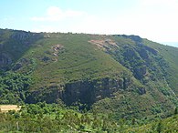
|File:Plegamiento de Campodola Leixazós en la Sierra do Caurel.JPG|[[Fold (geology)|Fold]] formation in Campodola-Leixazos, [[Serra do Courel]], [[Lugo Province]] |
|File:Plegamiento de Campodola Leixazós en la Sierra do Caurel.JPG|[[Fold (geology)|Fold]] formation in Campodola-Leixazos, [[Serra do Courel]], [[Lugo Province]] |
||
|File:Pico Sacro Galicia 001.jpg|Pico Sacro near [[Boqueixón]] |
|File:Pico Sacro Galicia 001.jpg|[[Pico Sacro]] near [[Boqueixón]] |
||
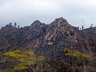
|File:Montañas en Verín.jpg|Mountain peaks near [[Verín]] |
|File:Montañas en Verín.jpg|Mountain peaks near [[Verín]] |
||
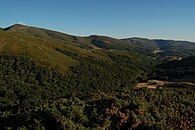
|File:Serra do Faro de Avión.jpg|View of [[Serra do Faro]] |
|File:Serra do Faro de Avión.jpg|View of [[Serra do Faro]] |
||
| Line 83: | Line 77: | ||
==References== |
==References== |
||
{{reflist}} |
{{reflist|30em}} |
||
*{{Translation/Ref|gl|Macizo Galaico|oldid=2668143}} |
|||
==External links== |
==External links== |
||
*{{commons category |
*{{commons category-inline}} |
||
*[http://www.senderisme.com/terrfile.aspx?idioma=en-IE&idterr=332 Macizo Galaico (Chain) - Hiking Geographic Card] |
*[http://www.senderisme.com/terrfile.aspx?idioma=en-IE&idterr=332 Macizo Galaico (Chain) - Hiking Geographic Card] {{Webarchive|url=https://web.archive.org/web/20140714182644/http://www.senderisme.com/terrfile.aspx?idioma=en-IE&idterr=332 |date=2014-07-14 }} |
||
*[http://www.iberianature.com/material/spaingeology.html Physical geography and geology of Spain] |
*[http://www.iberianature.com/material/spaingeology.html Physical geography and geology of Spain] |
||
*[http://www.maps.data-spain.com/cadastral Virtual Cadastral] |
*[https://web.archive.org/web/20080509082543/http://www.maps.data-spain.com/cadastral/ Virtual Cadastral] |
||
{{Mountains of Spain}} |
{{Mountains of Spain}} |
||
[[Category:Galician Massif| ]] |
[[Category:Galician Massif| ]] |
||
[[Category:Mountain ranges of Galicia (Spain)]] |
|||
[[Category:Mountain ranges of Castile and León]] |
|||
[[Category:Physiographic provinces]] |
|||
Latest revision as of 19:29, 28 June 2024
| Galician Massif | |
|---|---|
| Macizo Galaico Macizo Galaico-Leonés | |
 | |
| Highest point | |
| Peak | Peña Trevinca |
| Elevation | 2,124 m (6,969 ft) |
| Coordinates | 42°14′33″N 6°47′45″W / 42.24250°N 6.79583°W |
| Geography | |
 Topographic map of Galicia
| |
| Country | Spain |
| Autonomous Communities | Galicia and Castile and León |
| Range coordinates | 42°30′N 8°6′W / 42.500°N 8.100°W |
| Geology | |
| Orogeny | Variscan orogeny |
| Age of rock | Paleozoic |
| Type of rock | Schist, gneiss and granite |
The Galician Massif or Galician-Leonese Massif (Spanish: Macizo Galaico, also known as Macizo Galaico-Leonés) is a system of mountain ranges in the northwestern corner of the Iberian Peninsula. It is located in Galicia with its southeastern end reaching into the provinces of Zamora and León of Castile and León. Its highest point is Pena Trevinca at 2,127 metres (6,978 ft) . Another important peak is Cabeza de Manzaneda (1,781 m).
In traditional local folklore the forests of the Galician System are said to be inhabited by a variety of elves, fairies, ghosts, the Santa Compaña, the Nubeiro and witches (meigas).
Geology
[edit]Geomorphologically the Galician Massif is a northwestern prolongation of the Meseta Central, the inner Iberian plateau and has great affinity with the geology of the Tras os Montes Portuguese region, so that it is considered as a whole under the name 'Galicia-Trás-os-Montes Zone'.[1] It is composed of Paleozoic materials (granite) with metamorphic rocks such as gneiss, slate and schist in the center and west, which were subject to Alpine folding. Its eastern end merges with the Cantabrian Mountains.[2]
The relief of the system, with an average height of 500 metres (1,600 ft), is relatively smooth compared with other Iberian ranges. It is however very complex, having no defined structural alignment owing to the heavy fluvial erosion that has fragmented the terrain.
Generally the system includes mountains that are rounded in shape, often topped by small rocky outcrops, as well as horsts, basins and faults, roughly aligned in a N-S direction.
Vegetation
[edit]Since rain is abundant in Galicia, the undisturbed areas of the massif have a soft soil texture and are covered in dense vegetation of temperate deciduous forest where Quercus petraea and Quercus robur oaks predominate. The woods alternate with shrubland and wide natural meadows.[3]
The vegetation is quite homogeneous throughout the massif[4] and there is great plant biodiversity in the Galician mountains. Many of the species found in the mountains were used in Galician traditional medicine.[5]
The Serra dos Ancares was declared a UNESCO Biosphere Reserve in 2006.[6]
Mountain ranges
[edit]From the southeast to the northwest the Galician Massif has three physiographic longitudinal sections:
- The southwestern ranges; the highest elevations are found in this sector, including 2,047 m high Pena Trevinca, the highest point of the whole system. These ranges reach into the provinces of León and Zamora, hence the alternative name Macizo Galaico-Leonés, and show scars of the glacial period, which are apparent in the Serra do Eixe, also known as Serra da Segundera (Spanish: Sierra Segundera). Rivers Tera, Cabreira and Bibei run through glacial valleys and the San Martín de Castañeda Lake, Laguna de Lacillo lakes are moraine-dammed lakes.
- The Galician Dorsal Range; with 1,778 m high Cabeza de Manzaneda, its highest elevation. A tectonic basin running in a north–south direction separates it from the southwestern ranges. It includes the Central Ourensan Massif.
- The coastal ranges; such as Serra da Barbanza, are generally of a much lesser height and are separated from the Galician Dorsal Range by the Tui-Verín-Vigo intermontane basin.
List of ranges
[edit]
- Serra de Meira
- Serra de Xistral
- Serra da Barbanza
- Serra da Cova da Serpe
- Serra do Faro
- Testeiro Range
- Galiñeiro Range
- Serra do Courel
- Serra dos Ancares
- Central Ourensan Massif
- Serra do Suído
- Serra do Eixe
- Serra do Xurés
Main ranges and features
[edit]-
-
 Pico Sacro near Boqueixón
 -
 Mountain peaks near Verín
 -
 View of Serra do Faro


See also
[edit]References
[edit]- ^ Silurian graptolite biostratigraphy of the Galicia - Tras-os-Montes Zone (Spain and Portugal)
- ^ Wes Gibbons & Teresa Moreno, The geology of Spain. Geological Society of London, 2003
- ^ CSIC List of Iberian flora Quercus sp. (in Spanish)
- ^ Assessing the impact of wind farms on the plant diversity of blanket bogs in the Xistral Mountains (NW Spain)[permanent dead link]
- ^ Medicinal Use of Some Plants in Galicia (NW Spain)
- ^ Os Ancares UNESCO-MAB Biosphere Reserve
External links
[edit] Media related to Macizo Galaico-Leonés at Wikimedia Commons
- Macizo Galaico (Chain) - Hiking Geographic Card Archived 2014-07-14 at the Wayback Machine
- Physical geography and geology of Spain
- Virtual Cadastral