
Geography of Botswana: Difference between revisions
Danial Bass (talk | contribs) →Climate: move for cleaner look |
LucasBrown (talk | contribs) No edit summary |
||
| (15 intermediate revisions by 12 users not shown) | |||
| Line 1: | Line 1: | ||
{{Short description|none}} <!-- "none" is preferred when the title is sufficiently descriptive; see [[WP:SDNONE]] --> |
|||
{{Use dmy dates|date=June 2022}} |
{{Use dmy dates|date=June 2022}} |
||
{{Infobox country geography |
{{Infobox country geography |
||
|name = Botswana |
| name = Botswana |
||
|map = [[File:Botswana Map.jpg|250px]]<br>[[File:LocationBotswana.svg|240px]] |
| map = [[File:Botswana Map.jpg|250px]]<br>[[File:LocationBotswana.svg|240px]] |
||
|map size = 250px |
| map size = 250px |
||
|continent = [[Africa]] |
| continent = [[Africa]] |
||
|region = [[Southern Africa]] |
| region = [[Southern Africa]] |
||
|coordinates = {{coord|22|00|S|24|00|E|type:country}} |
| coordinates = {{coord|22|00|S|24|00|E|type:country}} |
||
|area ranking = 48th |
| area ranking = 48th |
||
|km area = 581730 |
| km area = 581730 |
||
|percent land = 97.42 |
| percent land = 97.42 |
||
|percent water = 2.58 |
| percent water = 2.58 |
||
|borders = [[Land borders|Total land borders]]: {{convert|4374.15|km|mi|abbr=on}}<br />[[Namibia]]: {{convert|1544|km|mi|abbr=on}}<br />[[South Africa]]: {{convert|1969|km|mi|abbr=on}}<br />[[Zambia]]: {{convert|0.15|km|mi|abbr=on}}<br />[[Zimbabwe]]: {{convert|834|km|mi|abbr=on}} |
| borders = [[Land borders|Total land borders]]: {{convert|4374.15|km|mi|abbr=on}}<br />[[Namibia]]: {{convert|1544|km|mi|abbr=on}}<br />[[South Africa]]: {{convert|1969|km|mi|abbr=on}}<br />[[Zambia]]: {{convert|0.15|km|mi|abbr=on}}<br />[[Zimbabwe]]: {{convert|834|km|mi|abbr=on}} |
||
|highest point = [[Tsodilo|Tsodilo Hills]] {{convert|1489|m|ft|0|abbr=on}} |
| highest point = [[Tsodilo|Tsodilo Hills]] {{convert|1489|m|ft|0|abbr=on}} |
||
|lowest point = Junction of the [[Limpopo River|Limpopo]] and [[Shashe River]]s {{convert|513|m|ft|0|abbr=on}} |
| lowest point = Junction of the [[Limpopo River|Limpopo]] and [[Shashe River]]s {{convert|513|m|ft|0|abbr=on}} |
||
|longest river = |
| longest river = |
||
|largest lake = |
| largest lake = |
||
}} |
|||
| ⚫ | |||
[[File:Botswana gweta 01.jpg|thumb|Gweta, Botswana]] |
|||
| ⚫ | '''[[Botswana]]''' is a landlocked country located in Southern [[Africa]], north of [[South Africa]]. [[Botswana]] occupies an area of {{convert|581730|km2|mi2}}, of which {{convert|566730|km2|mi2|abbr=on}} are land. Botswana has land boundaries of combined length {{convert|4347.15|km|mi}}, of which the constituent boundaries are shared with [[Namibia]], for {{convert|1544|km|mi|abbr=on}}; South Africa {{convert|1969|km|mi|abbr=on}}; [[Zimbabwe]], {{convert|834|km|mi|abbr=on}} and [[Zambia]], {{convert|0.15|km|mi|abbr=on}}. Much of the population of Botswana is concentrated in the eastern part of the country. |
||
Sunshine totals are high all year round although winter is the sunniest period. The whole country is windy and dusty during the dry season.<ref name="Landsberg">General Survey of Climatology, Landsberg (ed.),Elsevier, 2001</ref> |
Sunshine totals are high all year round although winter is the sunniest period. The whole country is windy and dusty during the dry season.<ref name="Landsberg">General Survey of Climatology, Landsberg (ed.),Elsevier, 2001</ref> |
||
==Area data== |
|||
; Area: |
|||
:* Total: 581,730 km² |
|||
:**''country rank in the world:'' 48th |
|||
:* Land: 566,730 km² |
|||
:* Water: 15,000 km² |
|||
; Area comparative |
|||
:* Australia comparative: approximately {{sfrac|5|7}} the size of [[New South Wales]] |
|||
:* Canada comparative: approximately {{sfrac|1|10}} smaller than [[Saskatchewan]] |
|||
:* United Kingdom comparative: approximately 2{{sfrac|2|5}} times the size of the United Kingdom |
|||
:* United States comparative: slightly less than twice the size of [[Arizona]] |
|||
:* [[European Union|EU]] comparative: slightly larger than [[Metropolitan France]] |
|||
==Geography== |
==Geography== |
||
The land is predominantly flat to gently undulating [[tableland]], although there is some hilly country, where mining is carried out. The [[Kalahari Desert]] is in the central and the southwest. |
The land is predominantly flat to gently undulating [[Plateaus|tableland]], although there is some hilly country, where [[Mining industry of Botswana|mining]] is carried out. The [[Kalahari Desert]] is in the central and the southwest. The [[Okavango Delta]], one of the world's largest inland deltas, is in the northwest and the [[Makgadikgadi Pans]], a large [[Salt pan (geology)|salt pan]] lies in the north-central area. The Makgadikgadi has been established as an early habitation area for primitive man; This large seasonal [[wetland]] is composed of several large component pans, the largest being [[Nwetwe Pan]], [[Sua Pan]] and [[Nxai Pan]].<ref>C. Michael Hogan (2008) [http://www.megalithic.co.uk/article.php?sid=22373&mode=&order=0 ''Makgadikgadi'', Megalithic Portal, ed. A.Burnham]</ref> Botswana's lowest elevation point is at the junction of the [[Limpopo River|Limpopo]] and Shashe Rivers, at a height of {{convert|513|m|ft|abbr=on}}. The highest point is [[Monalanong Hill]], at {{convert|1494|m|ft|abbr=on}}. |
||
The country is divided into four drainage regions, which are sometimes indistinct due to the arid nature of the climate: |
The country is divided into four drainage regions, which are sometimes indistinct due to the arid nature of the climate: |
||
* the [[Chobe River]] on the border with the [[Caprivi Strip]] of Namibia together with a small adjacent swampy area is part of the [[Zambezi]] basin; |
* the [[Chobe River]] on the border with the [[Caprivi Strip]] of Namibia together with a small adjacent swampy area is part of the [[Zambezi]] basin; |
||
* most of the north and central region of the country is part of the [[Okavango Basin|Okavango]] inland drainage basin; |
* most of the north and central region of the country is part of the [[Okavango Basin|Okavango]] inland [[drainage basin]]; |
||
* the easternmost part of the country falls into the [[Limpopo]] drainage basin; |
* the easternmost part of the country falls into the [[Limpopo]] drainage basin; |
||
* the southern and southwestern regions, which are the driest of all, are drained by the Molopo river along the South African border and the [[Nossob River|Nossob river]] through the [[Kgalagadi Transfrontier Park|Kalahari Gemsbok National Park]], and are technically part of the basin of the [[Orange River]]. None of these rivers normally flows as far as the Orange, however. (The last recorded confluence was in the 1880s.)<ref>Times Comprehensive Atlas, (2007), Times Books, London</ref> |
* the southern and southwestern regions, which are the driest of all, are drained by the [[Molopo River|Molopo]] river along the South African border and the [[Nossob River|Nossob river]] through the [[Kgalagadi Transfrontier Park|Kalahari Gemsbok National Park]], and are technically part of the basin of the [[Orange River]]. None of these rivers normally flows as far as the Orange, however. (The last recorded confluence was in the 1880s.)<ref>Times Comprehensive Atlas, (2007), Times Books, London</ref> |
||
Except for the Chobe, Okavango, [[Boteti]] and [[Limpopo river]]s, most of Botswana's rivers cease to flow during the dry and early rainy seasons. |
Except for the Chobe, Okavango, [[Boteti]] and [[Limpopo river]]s, most of Botswana's rivers cease to flow during the dry and early rainy seasons. |
||
==Climate== |
==Climate== |
||
Botswana is semi-arid, due to the short rain season. However, the relatively high altitude of the country and its continental situation gives it a subtropical climate. The country is remote from moisture-laden air flows for most of the year. The dry season lasts from April to October in the south and to November in the north where, however, rainfall totals are higher. The south of the country is most exposed to cold winds during the winter period (early May to late August) when average temperatures are around {{convert|14|°C|1}}. The whole country has hot summers with average temperatures around {{convert|26|°C|1}}. Sunshine totals are high all year round although winter is the sunniest period. The whole country is windy and dusty during the dry season.<ref name="Landsberg" /><gallery widths="170" heights="140" class="center"> |
Botswana is semi-arid, due to the short rain season. However, the relatively high altitude of the country and its continental situation gives it a subtropical climate. The country is remote from moisture-laden air flows for most of the year. The dry season lasts from April to October in the south and to November in the north where, however, rainfall totals are higher. The south of the country is most exposed to cold winds during the winter period (early May to late August) when average temperatures are around {{convert|14|°C|1}}. The whole country has hot summers with average temperatures around {{convert|26|°C|1}}. Sunshine totals are high all year round although winter is the sunniest period. The whole country is windy and dusty during the dry season.<ref name="Landsberg" /><gallery widths="170" heights="140" class="center"> |
||
File: |
File:Koppen-Geiger Map BWA present.svg|alt=|Botswana map of Köppen climate classification zones |
||
File:Botswana sat.png|alt=|Satellite image of Botswana |
File:Botswana sat.png|alt=|Satellite image of Botswana |
||
File:Botswana Topography.png|alt=|Elevation map of Botswana |
File:Botswana Topography.png|alt=|Elevation map of Botswana |
||
Latest revision as of 20:32, 12 June 2024
  | |
| Continent | Africa |
|---|---|
| Region | Southern Africa |
| Coordinates | 22°00′S 24°00′E / 22.000°S 24.000°E |
| Area | Ranked 48th |
| • Total | 581,730 km2 (224,610 sq mi) |
| • Land | 97.42% |
| • Water | 2.58% |
| Borders | Total land borders: 4,374.15 km (2,717.97 mi) Namibia: 1,544 km (959 mi) South Africa: 1,969 km (1,223 mi) Zambia: 0.15 km (0.093 mi) Zimbabwe: 834 km (518 mi) |
| Highest point | Tsodilo Hills 1,489 m (4,885 ft) |
| Lowest point | Junction of the Limpopo and Shashe Rivers 513 m (1,683 ft) |

Botswana is a landlocked country located in Southern Africa, north of South Africa. Botswana occupies an area of 581,730 square kilometres (224,610 sq mi), of which 566,730 km2 (218,820 sq mi) are land. Botswana has land boundaries of combined length 4,347.15 kilometres (2,701.19 mi), of which the constituent boundaries are shared with Namibia, for 1,544 km (959 mi); South Africa 1,969 km (1,223 mi); Zimbabwe, 834 km (518 mi) and Zambia, 0.15 km (0.093 mi). Much of the population of Botswana is concentrated in the eastern part of the country.
Sunshine totals are high all year round although winter is the sunniest period. The whole country is windy and dusty during the dry season.[1]
Area data
[edit]- Area
-
- Total: 581,730 km²
- country rank in the world: 48th
- Land: 566,730 km²
- Water: 15,000 km²
- Total: 581,730 km²
- Area comparative
-
- Australia comparative: approximately 5/7 the size of New South Wales
- Canada comparative: approximately 1/10 smaller than Saskatchewan
- United Kingdom comparative: approximately 22/5 times the size of the United Kingdom
- United States comparative: slightly less than twice the size of Arizona
- EU comparative: slightly larger than Metropolitan France
Geography
[edit]The land is predominantly flat to gently undulating tableland, although there is some hilly country, where mining is carried out. The Kalahari Desert is in the central and the southwest. The Okavango Delta, one of the world's largest inland deltas, is in the northwest and the Makgadikgadi Pans, a large salt pan lies in the north-central area. The Makgadikgadi has been established as an early habitation area for primitive man; This large seasonal wetland is composed of several large component pans, the largest being Nwetwe Pan, Sua Pan and Nxai Pan.[2] Botswana's lowest elevation point is at the junction of the Limpopo and Shashe Rivers, at a height of 513 m (1,683 ft). The highest point is Monalanong Hill, at 1,494 m (4,902 ft). The country is divided into four drainage regions, which are sometimes indistinct due to the arid nature of the climate:
- the Chobe River on the border with the Caprivi Strip of Namibia together with a small adjacent swampy area is part of the Zambezi basin;
- most of the north and central region of the country is part of the Okavango inland drainage basin;
- the easternmost part of the country falls into the Limpopo drainage basin;
- the southern and southwestern regions, which are the driest of all, are drained by the Molopo river along the South African border and the Nossob river through the Kalahari Gemsbok National Park, and are technically part of the basin of the Orange River. None of these rivers normally flows as far as the Orange, however. (The last recorded confluence was in the 1880s.)[3]
Except for the Chobe, Okavango, Boteti and Limpopo rivers, most of Botswana's rivers cease to flow during the dry and early rainy seasons.
Climate
[edit]Botswana is semi-arid, due to the short rain season. However, the relatively high altitude of the country and its continental situation gives it a subtropical climate. The country is remote from moisture-laden air flows for most of the year. The dry season lasts from April to October in the south and to November in the north where, however, rainfall totals are higher. The south of the country is most exposed to cold winds during the winter period (early May to late August) when average temperatures are around 14 °C (57.2 °F). The whole country has hot summers with average temperatures around 26 °C (78.8 °F). Sunshine totals are high all year round although winter is the sunniest period. The whole country is windy and dusty during the dry season.[1]
-
 Botswana map of Köppen climate classification zones
 -
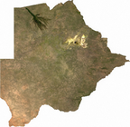 Satellite image of Botswana
 -
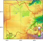 Elevation map of Botswana


| Climate data for Gaborone (Sir Seretse Khama Airport, 1981–2010) | |||||||||||||
|---|---|---|---|---|---|---|---|---|---|---|---|---|---|
| Month | Jan | Feb | Mar | Apr | May | Jun | Jul | Aug | Sep | Oct | Nov | Dec | Year |
| Record high °C (°F) | 39 (103) |
40 (104) |
39 (102) |
37 (98) |
33 (91) |
29 (84) |
28 (83) |
33 (91) |
39 (103) |
38 (100) |
40 (104) |
39 (103) |
40 (104) |
| Mean daily maximum °C (°F) | 32.7 (90.9) |
32.1 (89.8) |
30.8 (87.4) |
28.4 (83.1) |
25.6 (78.1) |
23.1 (73.6) |
22.9 (73.2) |
26.2 (79.2) |
30.0 (86.0) |
32.0 (89.6) |
32.3 (90.1) |
32.5 (90.5) |
29.1 (84.4) |
| Daily mean °C (°F) | 25.7 (78.3) |
25.2 (77.4) |
23.7 (74.7) |
20.6 (69.1) |
16.8 (62.2) |
13.7 (56.7) |
13.5 (56.3) |
16.9 (62.4) |
21.2 (70.2) |
24.0 (75.2) |
24.7 (76.5) |
25.3 (77.5) |
20.9 (69.6) |
| Mean daily minimum °C (°F) | 19.7 (67.5) |
19.3 (66.7) |
17.4 (63.3) |
13.5 (56.3) |
8.3 (46.9) |
5.0 (41.0) |
4.4 (39.9) |
7.5 (45.5) |
12.3 (54.1) |
16.3 (61.3) |
17.7 (63.9) |
18.8 (65.8) |
13.4 (56.1) |
| Record low °C (°F) | 14 (57) |
13 (55) |
11 (52) |
0 (32) |
−1 (30) |
−1 (30) |
−2 (28) |
0 (32) |
5 (41) |
7 (45) |
8 (46) |
11 (52) |
−2 (28) |
| Average precipitation mm (inches) | 143 (5.6) |
82 (3.2) |
74 (2.9) |
30 (1.2) |
8.3 (0.33) |
7.5 (0.30) |
1 (0.0) |
0.9 (0.04) |
5.8 (0.23) |
5.8 (0.23) |
58 (2.3) |
71 (2.8) |
487.3 (19.13) |
| Average precipitation days | 6 | 5 | 5 | 3 | 2 | 1 | 1 | 1 | 2 | 4 | 5 | 6 | 41 |
| Source 1: African Regional Climate Centre[4] | |||||||||||||
| Source 2: Weatherbase (records)[5] | |||||||||||||
Natural hazards
[edit]Botswana is affected by periodic droughts, and seasonal August winds blow from the west, carrying sand and dust, which can obscure visibility.
Environment
[edit]
Current environmental issues in Botswana are overgrazing, desertification and the existence of only limited fresh water resources.
Research from scientists has found that the common practice of overstocking cattle to cope with drought losses actually depletes scarce biomass, making ecosystems more vulnerable. The study of the district predicts that by 2050 the cycle of mild drought is likely to become shorter —18 months instead of two years—due to climate change.[6]
International agreements
[edit]Botswana is a party to the following international agreements: Biodiversity, Climate Change, Desertification, Endangered Species, Hazardous Wastes, Law of the Sea, Nuclear Test Organization, Ozone Layer Protection and Wetlands.
Extreme points
[edit]This is a list of the extreme points of Botswana, the points that are farther north, south, east or west than any other location.
- Northernmost point – the border with Zambia upon the Zambezi River at Chobe District
- Easternmost point – the tripoint with South Africa and Zimbabwe, Central District
- Southernmost point – Bokspits, Kgalagadi District
- Westernmost point – the western section of the border with Namibia*
- note: Botswana does not have a westernmost point as the western section is formed by the 22nd meridian of longitude east of Greenwich.
References
[edit]- ^ a b General Survey of Climatology, Landsberg (ed.),Elsevier, 2001
- ^ C. Michael Hogan (2008) Makgadikgadi, Megalithic Portal, ed. A.Burnham
- ^ Times Comprehensive Atlas, (2007), Times Books, London
- ^ "Precipitation and temperature reference climatologies: Seretse Khama International Airport". African Regional Climate Centre. Archived from the original on 14 March 2016. Retrieved 19 January 2016.
- ^ "Weatherbase: Historical Weather for Gaborone, Botswana". Weatherbase. Archived from the original on 24 September 2012. Retrieved 26 June 2012.
- ^ Sub-Saharan Africa news in brief: 10–22 April 2008 – SciDev.Net
