
Geography of the Dominican Republic: Difference between revisions
Tags: Reverted Mobile edit Mobile web edit |
Restored revision 1216290619 by CoolieCoolster (talk) |
||
| (28 intermediate revisions by 16 users not shown) | |||
| Line 1: | Line 1: | ||
{{Short description|none}} |
|||
{{Country geography |
|||
{{Country geography | |
|||
| name = Dominican Republic |
|||
name = Dominican Republic | |
|||
map = File:Dominican Republic relief location map.jpg| |
|||
continent = [[North America]] | |
|||
region = [[Caribbean]]<br />[[Greater Antilles]]| |
|||
coordinates =19°00' N 70°40' W | |
|||
area ranking = 131st | |
|||
percent land= 99.2| |
|||
km area = 48670 | |
|||
km coastline = 1,288 | |
|||
borders =[[Land borders|Total land borders]]:<br />275 km| |
|||
highest point= [[Pico Duarte]]<br />3,098 m| |
|||
lowest point= [[Lake Enriquillo]]<br />-46 m| |
|||
longest river= [[Yaque del Norte River]]| |
|||
largest lake= [[Lake Enriquillo]]| |
|||
|exclusive economic zone={{convert|255,898|km2|mi2|abbr=on}} |
|||
}} |
}} |
||
The |
The '''Dominican Republic''' (Spanish: ''República Dominicana'') is a country in the [[Caribbean|West Indies]] that occupies the eastern five-eighths of [[Hispaniola]]. It has an area of 48,670 km<sup>2</sup>, including offshore islands. The land border shared with [[Haiti]], which occupies the western three-eighths of the island,<ref name="Dardik">{{cite book|url=https://books.google.com/books?id=de9NDQAAQBAJ |title=Vascular Surgery: A Global Perspective |editor=Dardik, Alan |page=341 |year=2016 |publisher=Springer |isbn=9783319337456 |access-date=8 May 2017}}</ref><ref name="Current Affairs">{{cite web|url=https://books.google.com/books?id=5wBsDQAAQBAJ |title=Current Affairs November 2016 eBook |editor=Josh, Jagran |page=93 |year=2016 |access-date=8 May 2017}}</ref> is 376 km long.<ref>{{cite web| url = https://www.cia.gov/the-world-factbook/countries/haiti/| title = CIA World Factbook: Haiti| date = 12 July 2022}}</ref> The maximum length, east to west, is 390 km from Punta de Agua to Las Lajas, on the border with Haiti. The maximum width, north to south, is 265 km from Cape Isabela to Cape Beata.<ref name="santiago">{{cite book | last = De la Fuente | first = Santiago | title = Geografía Dominicana | publisher = Editora Colegial Quisqueyana | year = 1976 | location = Santo Domingo, Dominican Republic | pages = 90–92 }}</ref> The [[Capital (political)|capital]], [[Santo Domingo]], is located on the south coast. |
||
The Dominican Republic's shores are washed by the [[Atlantic Ocean]] to the north and the [[Caribbean Sea]] to the south. The [[Mona Passage]], a channel about 130 km wide, separates the country (and Hispaniola) from [[Puerto Rico]].<ref>{{Cite news|url=https://www.britannica.com/place/Dominican-Republic|title=Dominican Republic{{!}} History, Geography, & Culture|work= |
The [[Dominican Republic]]'s shores are washed by the [[Atlantic Ocean]] to the north and the [[Caribbean Sea]] to the south. The [[Mona Passage]], a channel about 130 km wide, separates the country (and Hispaniola) from [[Puerto Rico]].<ref>{{Cite news|url=https://www.britannica.com/place/Dominican-Republic|title=Dominican Republic{{!}} History, Geography, & Culture|work=Encyclopædia Britannica|access-date=2018-02-21|language=en}}</ref> |
||
The country has 10.8 million inhabitants (2020), of which approximately 3.3 million live in the metropolitan area of Santo Domingo. Since the end of the 1990s, the country has had significant economic growth, mainly due to revenues from [[tourism]]. The Dominican Republic is the most visited destination in the Caribbean.<ref name = "WTO Tourism Highlights 2018 Edition">{{Cite book|title = UNWTO Tourism Highlights: 2018 Edition {{!}} World Tourism Organization|doi = 10.18111/9789284419876|year = 2018 |isbn = 9789284419876 | s2cid = 240334031}}</ref> The United States is the country's most important trading partner. The official language of the country is Spanish and English, French, Haitian, Jewish, Chinese and Japanese as minority languages. |
|||
== Physical features == |
== Physical features == |
||
| Line 41: | Line 40: | ||
* The ''[[Cibao]]'' Valley (Dominican Republic) is the largest and the most important valley of the country. This long valley stretches from North Haiti, where is called ''[[Plain]]e du Nord'', to Samaná Bay. It can be divided in two sections: the northwestern part is the ''Yaque del Norte Valley'' (or ''Línea Noroeste'') and the eastern ''Yuna Valley'' (or ''Vega Real'', English: ''Royal Valley''). The ''Vega Real'' is the most fertile area in the country, with a high population density. |
* The ''[[Cibao]]'' Valley (Dominican Republic) is the largest and the most important valley of the country. This long valley stretches from North Haiti, where is called ''[[Plain]]e du Nord'', to Samaná Bay. It can be divided in two sections: the northwestern part is the ''Yaque del Norte Valley'' (or ''Línea Noroeste'') and the eastern ''Yuna Valley'' (or ''Vega Real'', English: ''Royal Valley''). The ''Vega Real'' is the most fertile area in the country, with a high population density. |
||
* The ''[[Cordillera Central, Dominican Republic|Cordillera Central]]'' (also called ''Sierra del Cibao'') is the island's most rugged and imposing feature and is known in Haiti as the ''Massif du Nord'' ("Northern Massif"). The highest mountains of the West Indies are in this range: [[Pico Duarte]], 3,098 m, and others above 3,000 m. Near the center of the island, this range turns southward and is called ''Sierra de Ocoa'', finishing near the city of Azua de Compostela, on the Caribbean coast. Another branch, ''Cordillera Oriental'' or ''Sierra del Seibo'', is separated from the main chain by a [[Karst topography|karst]]ic region (''Los Haitises'') and with a west–east direction; it is located south of Samaná Bay. |
* The ''[[Cordillera Central, Dominican Republic|Cordillera Central]]'' (also called ''Sierra del Cibao'') is the island's most rugged and imposing feature and is known in Haiti as the ''Massif du Nord'' ("Northern Massif"). The highest mountains of the West Indies are in this range: [[Pico Duarte]], 3,098 m, and others above 3,000 m. Near the center of the island, this range turns southward and is called ''Sierra de Ocoa'', finishing near the city of Azua de Compostela, on the Caribbean coast. Another branch, ''Cordillera Oriental'' or ''Sierra del Seibo'', is separated from the main chain by a [[Karst topography|karst]]ic region (''Los Haitises'') and with a west–east direction; it is located south of Samaná Bay. |
||
[[File:Habitat Sphaerodactylus epiurus MG 9092.jpg|thumb|right|Cordillera Oriental landscape in Dominican Republic.]] |
|||
* The ''San Juan Valley'' and ''[[Plain]] of Azua'' are big valleys south of the ''Cordillera Central'' with altitude from 0 to 600 m. |
* The ''San Juan Valley'' and ''[[Plain]] of Azua'' are big valleys south of the ''Cordillera Central'' with altitude from 0 to 600 m. |
||
* The ''Sierra de Neiba'', with Mount Neiba the highest mountain with 2,279 m. An extension to the southeast of ''Sierra de Neiba'' is the ''Sierra Martín García'' (''Loma Busú'', 1,350 m). |
* The ''Sierra de Neiba'', with Mount Neiba the highest mountain with 2,279 m. An extension to the southeast of ''Sierra de Neiba'' is the ''Sierra Martín García'' (''Loma Busú'', 1,350 m). |
||
* The ''Hoya de Enriquillo'' or ''Neiba Valley'' is a remarkable valley, with a west–east direction, of low altitude (on average 50 m with some points below sea level) and with a great salt lake: the ''[[Enriquillo Lake]]''. |
* The ''Hoya de Enriquillo'' or ''Neiba Valley'' is a remarkable valley, with a west–east direction, of low altitude (on average 50 m with some points below sea level) and with a great salt lake: the ''[[Enriquillo Lake]]''. |
||
* The ''Sierra de Bahoruco'', called ''Massif de la Selle'' in Haiti. This southern group of mountains have a geology very different from the rest of the island. |
* The ''Sierra de Bahoruco'', called ''Massif de la Selle'' in Haiti. This southern group of mountains have a geology very different from the rest of the island. |
||
* ''Llano Costero del Caribe'' (in English, "Caribbean Coastal Plain") is in the southeast of the island (and of the Dominican Republic). It is a large [[ |
* ''Llano Costero del Caribe'' (in English, "Caribbean Coastal Plain") is in the southeast of the island (and of the Dominican Republic). It is a large [[savanna]] east of [[Santo Domingo]]. |
||
[[File:Eastern Cibao banner.jpg|thumb|center|770px|A beach in the Samana province]] |
[[File:Eastern Cibao banner.jpg|thumb|center|770px|A beach in the Samana province]] |
||
| Line 51: | Line 51: | ||
==Climate== |
==Climate== |
||
[[File:Dominican Republic Köppen.svg|216px|thumb|[[Köppen climate classification system|Köppen climate types]] of the Dominican Republic]] |
[[File:Dominican Republic Köppen.svg|216px|thumb|[[Köppen climate classification system|Köppen climate types]] of the Dominican Republic]] |
||
The Dominican Republic is a [[tropical]], [[maritime nation]]. Owing to its diverse mountainous topography the country's climate shows considerable variation for its size, and has the most diverse climate zones of all the Caribbean islands. Conditions are ameliorated in many areas by elevation and by the northeast [[trade winds]], which blow steadily from the [[Atlantic]] all year long. The annual mean [[temperature]] is {{convert|25|°C}}; regional mean temperatures range from {{convert|18|°C|1}} in the heart of the Cordillera Central ([[Constanza, Dominican Republic|Constanza]]) to as high as {{convert|27|°C|1}} in arid regions. Temperatures rarely rise above {{convert|32|°C|1}}, and freezing temperatures only occur in winter in the highest mountains. The average temperature in [[Santo Domingo]] in January is {{convert|24|°C|1}}, and {{convert|27|°C|1}} in July. |
The Dominican Republic is a [[tropical]], [[maritime nation]]. Owing to its diverse mountainous topography, the country's climate shows considerable variation for its size, and has the most diverse climate zones of all the Caribbean islands, including [[subtropical highland climate]]s (''Cwb''), [[oceanic climate]]s (''Cfb'') and [[hot semi-arid climate]]s (''BSh'') along the usual [[tropical savanna climate|tropical savanna]] (''Aw''), [[tropical monsoon climate|monsoon]] (''Am''), and [[Tropical rainforest climate|rainforest]] (''Af'') climates typical of a Caribbean nation. Conditions are ameliorated in many areas by elevation and by the northeast [[trade winds]], which blow steadily from the [[Atlantic]] all year long. The annual mean [[temperature]] is {{convert|25|°C}}; regional mean temperatures range from {{convert|18|°C|1}} in the heart of the [[Cordillera Central, Dominican Republic|Cordillera Central]] ([[Constanza, Dominican Republic|Constanza]]) to as high as {{convert|27|°C|1}} in arid regions. Temperatures rarely rise above {{convert|32|°C|1}}, and freezing temperatures only occur in winter in the highest mountains. The average temperature in [[Santo Domingo]] in January is {{convert|24|°C|1}}, and {{convert|27|°C|1}} in July. |
||
The rain season for the northern coast is from November to January. For the rest of the country, the rain season is from May to November. The average annual rainfall is {{convert|1346|mm|in|abbr=on}}, with extremes of {{convert|2500|mm|in|1|abbr=on}} or more in the mountainous northeast (the windward side of the island) and {{convert|500|mm|in|1|abbr=on}} in the southwestern valleys. The western valleys, along the Haitian border, remain relatively dry, with less than {{convert|760|mm|in|1|abbr=on}} of annual precipitation, due to the [[rain shadow]] effect caused by the central and northern mountain ranges. The northwestern and southeastern extremes of the country are also arid. |
The rain season for the northern coast is from November to January. For the rest of the country, the rain season is from May to November. The average annual rainfall is {{convert|1346|mm|in|abbr=on}}, with extremes of {{convert|2500|mm|in|1|abbr=on}} or more in the mountainous northeast (the windward side of the island) and {{convert|500|mm|in|1|abbr=on}} in the southwestern valleys. The western valleys, along the Haitian border, remain relatively dry, with less than {{convert|760|mm|in|1|abbr=on}} of annual precipitation, due to the [[rain shadow]] effect caused by the central and northern mountain ranges. The northwestern and southeastern extremes of the country are also arid. |
||
The Dominican Republic is located in the [[tropical]] climate belt and also has typical tropical [[weather]]. Evenly warm all year round with an average temperature of 25 °C. It happens all year round that a [[cyclone]] runs across the country and there are heavy rain showers, hail, floats, hurricanes and sometimes also thunderstorms in the summer months on the whole island of Hispaniola, both in the Dominican Republic and in Haiti and in the winter period in the north areas, in the mountains and in the valleys some snow may come but due to the high temperatures the snow melts away very quickly again and but mostly in the winter period and in northern areas, the mountains and in the valleys it can well past to other rain really much with hail and or thunderstorms throughout the island of Hispaniola, both in the Dominican Republic and in Haiti. <ref>{{cite web | url=https://trome.pe/actualidad/internacional/nieve-republica-dominicana-fotos-caribe-video-video-constanza-37817/?outputType=amp | title=¿Nieve en República Dominicana?Estas fotos son del Caribe, no es broma [VIDEO] |
|||
| date=22 January 2017 }}</ref><ref>https://lodehoyrd.com/increible-cae-nieve-en-constanza-republica-dominicana/</ref><ref>https://www. telemundo47.com/noticias/local/ver-para-creer-epica-nevada-en-pleno-caribe/3224/?amp</ref> There is colder and more rainfall in the mountains, while the valleys and especially the eastern part does not get near as much [[precipitation]]. The precipitation and geography are favorable for soil cultivation and therefore approx. 2/3 of the area for [[agriculture]]. In the drier regions, agricultural land occurs as grazing areas. The [[Artibonite River|Artibonite]] River originates in the Dominican Republic and flows through [[Haiti]] into the [[Gonâve Bay]]. |
|||
The Dominican Republic is occasionally damaged by tropical storms and hurricanes, which originate in the mid-Atlantic and southeastern Caribbean from June until November (mainly from August to October) each year. |
The Dominican Republic is occasionally damaged by tropical storms and hurricanes, which originate in the mid-Atlantic and southeastern Caribbean from June until November (mainly from August to October) each year. |
||
<gallery mode="packed" heights="124px"> |
|||
File:Cabo Cabrón, (Rincón Beach) Samaná, DR.JPG|Tropical rainforest climate in [[Samaná Province|Samana]]. |
|||
{{Weather box |
|||
File:Constanza, valle nuevo, clima invierno..jpg|Frosted alpine forest in [[Constanza, Dominican Republic|Constanza]]. |
|||
|width = auto |
|||
File:Jaragua National Park (Road2).JPG|Semi-arid climate in [[Pedernales Province|Pedernales]]. |
|||
|location = Santo Domingo, Dominican Republic (1971-2000, extremes 1909-present) |
|||
File:Dunas de Baní 1.jpg|Desert sand dunes of [[Baní|Bani]]. |
|||
|metric first = yes |
|||
</gallery> |
|||
|single line = yes |
|||
|collapsed = Yes |
|||
|Jan record high C = 34.4 |
|||
|Feb record high C = 33.9 |
|||
|Mar record high C = 36.0 |
|||
|Apr record high C = 37.0 |
|||
|May record high C = 39.5 <!-- Recorded in May 2002 http://www.diariolibre.com/noticias/2011/01/07/i274915_frio-extremo-calor-agobiante.html --> |
|||
|Jun record high C = 37.2 |
|||
|Jul record high C = 37.8 |
|||
|Aug record high C = 38.8 |
|||
|Sep record high C = 36.7 |
|||
|Oct record high C = 38.8 |
|||
|Nov record high C = 35.0 |
|||
|Dec record high C = 33.5 |
|||
|year record high C = 39.5 |
|||
|Jan high C = 29.4 |
|||
|Feb high C = 29.3 |
|||
|Mar high C = 29.6 |
|||
|Apr high C = 30.3 |
|||
|May high C = 30.6 |
|||
|Jun high C = 31.3 |
|||
|Jul high C = 31.7 |
|||
|Aug high C = 31.8 |
|||
|Sep high C = 31.6 |
|||
|Oct high C = 31.3 |
|||
|Nov high C = 30.8 |
|||
|Dec high C = 29.8 |
|||
|year high C = 30.6 |
|||
|Jan mean C = 24.7 |
|||
|Feb mean C = 24.6 |
|||
|Mar mean C = 25.1 |
|||
|Apr mean C = 25.8 |
|||
|May mean C = 26.5 |
|||
|Jun mean C = 27.2 |
|||
|Jul mean C = 27.3 |
|||
|Aug mean C = 27.4 |
|||
|Sep mean C = 27.3 |
|||
|Oct mean C = 26.9 |
|||
|Nov mean C = 26.3 |
|||
|Dec mean C = 25.2 |
|||
|year mean C = 26.2 |
|||
|Jan low C = 20.0 |
|||
|Feb low C = 19.9 |
|||
|Mar low C = 20.5 |
|||
|Apr low C = 21.4 |
|||
|May low C = 22.5 |
|||
|Jun low C = 23.1 |
|||
|Jul low C = 23.0 |
|||
|Aug low C = 23.0 |
|||
|Sep low C = 23.0 |
|||
|Oct low C = 22.6 |
|||
|Nov low C = 21.9 |
|||
|Dec low C = 20.6 |
|||
|year low C = 21.8 |
|||
|Jan record low C = 11.0 <!-- http://www.diariolibre.com/noticias/2011/01/07/i274915_frio-extremo-calor-agobiante.html --> |
|||
|Feb record low C = 11.0 <!-- http://www.diariolibre.com/noticias/2011/01/07/i274915_frio-extremo-calor-agobiante.html --> |
|||
|Mar record low C = 13.3 |
|||
|Apr record low C = 15.5 |
|||
|May record low C = 16.5 |
|||
|Jun record low C = 18.6 |
|||
|Jul record low C = 18.2 |
|||
|Aug record low C = 18.0 |
|||
|Sep record low C = 18.0 |
|||
|Oct record low C = 17.0 |
|||
|Nov record low C = 17.0 |
|||
|Dec record low C = 13.0 |
|||
|year record low C = 11.0 |
|||
|rain colour = green |
|||
|Jan rain mm = 74.5 |
|||
|Feb rain mm = 67.9 |
|||
|Mar rain mm = 61.9 |
|||
|Apr rain mm = 72.1 |
|||
|May rain mm = 176.6 |
|||
|Jun rain mm = 116.4 |
|||
|Jul rain mm = 131.2 |
|||
|Aug rain mm = 178.1 |
|||
|Sep rain mm = 208.7 |
|||
|Oct rain mm = 186.2 |
|||
|Nov rain mm = 132.5 |
|||
|Dec rain mm = 82.9 |
|||
|year rain mm = 1489.0 |
|||
|Jan humidity = 82.0 |
|||
|Feb humidity = 81.1 |
|||
|Mar humidity = 80.1 |
|||
|Apr humidity = 79.4 |
|||
|May humidity = 82.2 |
|||
|Jun humidity = 82.2 |
|||
|Jul humidity = 82.2 |
|||
|Aug humidity = 83.3 |
|||
|Sep humidity = 84.0 |
|||
|Oct humidity = 84.8 |
|||
|Nov humidity = 84.0 |
|||
|Dec humidity = 82.6 |
|||
|year humidity = 82.3 |
|||
|unit rain days = 1.0 mm |
|||
|Jan rain days = 8.3 |
|||
|Feb rain days = 6.8 |
|||
|Mar rain days = 7.0 |
|||
|Apr rain days = 6.5 |
|||
|May rain days = 10.5 |
|||
|Jun rain days = 9.3 |
|||
|Jul rain days = 10.8 |
|||
|Aug rain days = 11.5 |
|||
|Sep rain days = 12.1 |
|||
|Oct rain days = 12.5 |
|||
|Nov rain days = 10.7 |
|||
|Dec rain days = 9.1 |
|||
|year rain days = 115.1 |
|||
|Jan sun = 239.7 |
|||
|Feb sun = 229.6 |
|||
|Mar sun = 253.4 |
|||
|Apr sun = 248.8 |
|||
|May sun = 233.9 |
|||
|Jun sun = 232.3 |
|||
|Jul sun = 225.9 |
|||
|Aug sun = 231.6 |
|||
|Sep sun = 219.9 |
|||
|Oct sun = 230.7 |
|||
|Nov sun = 227.5 |
|||
|Dec sun = 224.1 |
|||
|year sun = 2797.4 |
|||
|source 1 = ONAMET<ref name=normalessantodomingo> |
|||
{{cite web |
|||
| archive-url = https://web.archive.org/web/20191221040137/http://onamet.gob.do/transparencia/phocadownload/datos-abiertos/Datos-Extremos/Datos%20climatologicos%20normales%20y%20extremos%2071-2000%20estaciones%20Sinopticas%20-%20tercer%20trimestre%202019.xlsx |
|||
| archive-date = 21 December 2019 |
|||
| url = http://onamet.gob.do/transparencia/phocadownload/datos-abiertos/Datos-Extremos/Datos%20climatologicos%20normales%20y%20extremos%2071-2000%20estaciones%20Sinopticas%20-%20tercer%20trimestre%202019.xlsx |
|||
| title = Datos climatológicos normales y extremos 71-2000 estaciones Sinópticas - tercer trimestre 2019 |
|||
| publisher = Oficina Nacional de Meteorología |
|||
| language = es |
|||
| access-date = 20 December 2019}}</ref> |
|||
|source 2 = Diario Libre (May record high, and record lows for January and February),<ref name=recordssantodomingo>{{cite web |first1=Mariela |last1=Mejía |url=http://www.diariolibre.com/noticias/2011/01/07/i274915_frio-extremo-calor-agobiante.html |title=Frío extremo, calor agobiante |publisher=Diario Libre |language=es |date=7 January 2011 |access-date=2 May 2017 |archive-date=4 November 2013 |archive-url=https://web.archive.org/web/20131104214132/http://www.diariolibre.com/noticias/2011/01/07/i274915_frio-extremo-calor-agobiante.html |url-status=dead }}</ref> Meteo Climat (record highs and lows)<ref name = santodomingometeoclimat> |
|||
{{cite web |
|||
| url = http://meteo-climat-bzh.dyndns.org/index.php?page=stati&id=1747 |
|||
| title = Station Santo Domingo |
|||
| publisher = Meteo Climat |
|||
|language = fr |
|||
| access-date = 2 May 2017}}</ref> |
|||
|date=August 2010 |
|||
}} |
|||
{{Weather box |
|||
|location = Santiago de los Caballeros (1971-2000) |
|||
|metric first = yes |
|||
|single line = yes |
|||
|width = auto |
|||
|collapsed = Yes |
|||
|Jan record high C = 34.4 |
|||
|Feb record high C = 34.7 |
|||
|Mar record high C = 35.8 |
|||
|Apr record high C = 36.0 |
|||
|May record high C = 36.0 |
|||
|Jun record high C = 36.7 |
|||
|Jul record high C = 36.6 |
|||
|Aug record high C = 38.2 |
|||
|Sep record high C = 37.6 |
|||
|Oct record high C = 36.5 |
|||
|Nov record high C = 39.8 |
|||
|Dec record high C = 34.7 |
|||
|year record high C = 39.8 |
|||
|Jan high C = 28.9 |
|||
|Feb high C = 29.4 |
|||
|Mar high C = 30.4 |
|||
|Apr high C = 31.1 |
|||
|May high C = 31.9 |
|||
|Jun high C = 32.9 |
|||
|Jul high C = 33.1 |
|||
|Aug high C = 33.2 |
|||
|Sep high C = 33.1 |
|||
|Oct high C = 32.4 |
|||
|Nov high C = 30.5 |
|||
|Dec high C = 28.9 |
|||
|year high C = |
|||
|Jan mean C = 23.7 |
|||
|Feb mean C = 24.0 |
|||
|Mar mean C = 24.8 |
|||
|Apr mean C = 25.6 |
|||
|May mean C = 26.6 |
|||
|Jun mean C = 27.6 |
|||
|Jul mean C = 27.8 |
|||
|Aug mean C = 27.8 |
|||
|Sep mean C = 27.6 |
|||
|Oct mean C = 27.0 |
|||
|Nov mean C = 25.5 |
|||
|Dec mean C = 23.9 |
|||
|year mean C = |
|||
|Jan low C = 18.5 |
|||
|Feb low C = 18.7 |
|||
|Mar low C = 19.3 |
|||
|Apr low C = 20.2 |
|||
|May low C = 21.4 |
|||
|Jun low C = 22.4 |
|||
|Jul low C = 22.4 |
|||
|Aug low C = 22.4 |
|||
|Sep low C = 22.0 |
|||
|Oct low C = 21.6 |
|||
|Nov low C = 20.5 |
|||
|Dec low C = 19.0 |
|||
|year low C = |
|||
|Jan record low C = 11.2 |
|||
|Feb record low C = 12.2 |
|||
|Mar record low C = 12.5 |
|||
|Apr record low C = 12.7 |
|||
|May record low C = 16.3 |
|||
|Jun record low C = 18.5 |
|||
|Jul record low C = 17.0 |
|||
|Aug record low C = 17.6 |
|||
|Sep record low C = 18.6 |
|||
|Oct record low C = 17.5 |
|||
|Nov record low C = 15.0 |
|||
|Dec record low C = 12.1 |
|||
|year record low C = 11.2 |
|||
|rain colour = green |
|||
|Jan rain mm = 55.0 |
|||
|Feb rain mm = 42.3 |
|||
|Mar rain mm = 61.9 |
|||
|Apr rain mm = 109.3 |
|||
|May rain mm = 133.1 |
|||
|Jun rain mm = 63.7 |
|||
|Jul rain mm = 48.1 |
|||
|Aug rain mm = 71.9 |
|||
|Sep rain mm = 85.3 |
|||
|Oct rain mm = 112.4 |
|||
|Nov rain mm = 94.4 |
|||
|Dec rain mm = 68.2 |
|||
|year rain mm = |
|||
|unit rain days = 1.0 mm |
|||
|Jan rain days = 8.0 |
|||
|Feb rain days = 6.5 |
|||
|Mar rain days = 6.0 |
|||
|Apr rain days = 8.0 |
|||
|May rain days = 9.6 |
|||
|Jun rain days = 5.3 |
|||
|Jul rain days = 6.8 |
|||
|Aug rain days = 7.4 |
|||
|Sep rain days = 7.9 |
|||
|Oct rain days = 9.3 |
|||
|Nov rain days = 9.6 |
|||
|Dec rain days = 9.6 |
|||
|year rain days = |
|||
|Jan humidity = 77.2 |
|||
|Feb humidity = 75.1 |
|||
|Mar humidity = 71.6 |
|||
|Apr humidity = 71.5 |
|||
|May humidity = 73.5 |
|||
|Jun humidity = 71.0 |
|||
|Jul humidity = 70.5 |
|||
|Aug humidity = 71.5 |
|||
|Sep humidity = 73.4 |
|||
|Oct humidity = 75.4 |
|||
|Nov humidity = 78.4 |
|||
|Dec humidity = 78.5 |
|||
|year humidity = |
|||
|Jan sun = 224.1 |
|||
|Feb sun = 202.2 |
|||
|Mar sun = 245.2 |
|||
|Apr sun = 236.9 |
|||
|May sun = 242.7 |
|||
|Jun sun = 245.9 |
|||
|Jul sun = 255.1 |
|||
|Aug sun = 262.8 |
|||
|Sep sun = 234.5 |
|||
|Oct sun = 235.4 |
|||
|Nov sun = 212.2 |
|||
|Dec sun = 205.1 |
|||
|year sun = |
|||
|source 1 = ONAMET<ref name=normalessantiago>{{cite web |url=http://onamet.gob.do/transparencia/index.php/datos-abiertos/category/825-acumulado-precipitacion?download=907:datos-climatologicos-normales-y-extremos-71-2000-estaciones-sinopticas-tercer-trimestre-2019-xlsx |title=Datos climatológicos normales y extremos 71-2000 estaciones Sinópticas - tercer trimestre 2019 |publisher=Oficina Nacional de Meteorología |language=es |access-date=20 October 2020 |archive-date=16 August 2021 |archive-url=https://web.archive.org/web/20210816063954/https://optic.gob.do/nortic/images/sellos/onamet-sello-e1-2014/01-onamet.png |url-status=live }}</ref> |
|||
}} |
|||
== Islands == |
== Islands == |
||
[[File:Caribbean maritime boundaries map.svg|thumb|right|300px|Caribbean maritime boundaries.]] |
[[File:Caribbean maritime boundaries map.svg|thumb|right|300px|Caribbean maritime boundaries.]] |
||
There are several smaller islands and cays that are part of |
There are several smaller islands and cays that are part of Dominican territory. The largest islands are: |
||
#''[[Saona Island|Saona]]'', close to the southeastern coast of |
#''[[Saona Island|Saona]]'', close to the southeastern coast of Hispaniola, in the [[Caribbean Sea]]. It has an area of 117 km<sup>2</sup>.<ref name="santiago" /> Its [[Taíno people|Taíno]] name was ''Iai'' <ref name="Morales">As shown in a map made by Andrés Morales in 1508 and published in 1516. ''In'' {{cite book |
||
| last = Vega |
| last = Vega |
||
| first =Bernardo |
| first =Bernardo |
||
| Line 342: | Line 73: | ||
| year = 1989 |
| year = 1989 |
||
| location = Santo Domingo, Dominican Republic |
| location = Santo Domingo, Dominican Republic |
||
| page = 88 }}</ref> or ''Adamanay''. [[Christopher Columbus|Columbus]] named this island as Savona after the Italian city of the same name but the use during years has eliminated the letter ''v''. |
| page = 88 }}</ref> or ''Adamanay''. [[Christopher Columbus|Columbus]] named this island as Savona, after the [[Savona|Italian city of the same name]], but the use during years has eliminated the letter ''v''. |
||
#''[[Beata Island|Beata]]'', |
#''[[Beata Island|Beata]]'', also on the southern coast. It has an area of 27 km<sup>2</sup>.<ref name="santiago" /> Its Taíno name is unknown. Columbus named this island ''Madama Beata''. |
||
#''[[Catalina Island, Dominican Republic|Catalina]]'', very close to the southeastern coast |
#''[[Catalina Island, Dominican Republic|Catalina]]'', very close to the southeastern coast. It has an area of 9.6 km<sup>2</sup>.<ref name="santiago" /> Its Taíno name was ''Iabanea''<ref name="Morales" /> but some writers, including poets, say that it was called ''Toeya'' or ''Toella''. |
||
== Mountains, hills and valleys == |
|||
[[File: Dominican Republic relief location map.jpg|thumb|Topographic map of the Dominican Republic]] |
|||
[[File:hispaniola lrg.jpg|thumb |Topography of Hispaniola]] |
|||
[[File: ISS027-E-17333 - View of Dominican Republic.jpg|thumb| Dominican Republic Satellite Image]] |
|||
The Dominican Republic extends beyond two-thirds of the island [[Hispaniola]]. It is a [[mountain]] rich [[island]] with high forested mountains. There are 22 smaller mountain ranges on the island, Cordillera Septentrional, Cordillera Central, Cerro El Muerto, Loma del Muerto, Loma de los Muertos, Jornada del Muerto, Mount Isabel de Torres, Montaña Redonda, El Morro de Montecristi, Loma Del Gallo, Montañas del Cibao, Macizo de Tierra Nueva, (Pico la Selle "Morne La Selle"), Pic la Selle, (Massif de la Selle, Chaîne de la Selle), Monte del Cibao, Sierra Martín García, Sierra de Yamasá, Sierra de Samaná, San Juan de la Maguana and Loma De La Viuda (mountain), Firme del Medio, Loma Caracol, Laguna Limón, |
|||
Monte Redondov and Sierra de Bahoruco. La Pelona, Loma La Rucilla and Yaque some of the largest mountain. The highest mountain is [[Pico Duarte]] in the Cordillera Central. Between the chains lie deep, fertile [[valleys]] e, which are well supplied with water from the mountains. The entire eastern part is a lower, drier part. The water surface of [[Saltwater Lake]] a [[Lago de Enriquillo]], which is 40 meters below sea level, is also the lowest point in the [[Caribbean Islands]] and Lake Enriquillo is a hyperdaline lake in the Dominican Republic, located in the southwestern part of the country. Its waters are divided between the provinces of Bahoruco and Independencia, the latter bordering Haiti. [[Lake Enriquillo]] is the largest lake in both the Dominican Republic and Hispaniola as well as the entire Caribbean and Lake Enriquillo is home to saltwater crocodiles, iguanas, flamingos and many other animals.<ref>{{cite web | url=https://www.alamy.es/republica-dominicana-lago-enriquillo-guia-muestra-la-boca-de-cuatro-dias-de-edad-el-cocodrilo-de-agua-salada-image5636278.html | title=República Dominicana Lago Enriquillo guía muestra la boca de cuatro días de edad el cocodrilo de agua salada Fotografía de stock - Alamy }}</ref><ref>{{cite web | url=https://serturista.com/republica-dominicana/caimanes-de-agua-salada-en-el-lago-enriquillo/ | title=Caimanes de agua salada en el Lago Enriquillo - República Dominicana - Ser Turista | date=12 December 2011 }}</ref><ref name="fishipedia1">{{cite web | url=https://www.fishipedia.es/reptil/countries/republique-dominicaine | title=República Dominicana - Lista de reptiles }}</ref><ref>{{cite web | url=https://www.iglobal.co/republica-dominicana/search-amp/cocodrilos-de-agua-salada | title=COCODRILOS DE AGUA SALADA en REPúBLICA DOMINICANA }}</ref><ref>{{cite web | url=https://www.conectate.com.do/articulo/cocodrilo-americano-crocodylus-acutus-republica-dominicana/ | title=Cocodrilo Americano | American Crocodile | Crocodylus Acutus | date=10 July 2021 }}</ref><ref>{{cite web | url=https://hoy.com.do/un-cocodrilo-paso-cinco-anos-con-neumatico-en-el-cuello/ | title=Un cocodrilo pasó cinco años con neumático en el cuello | date=9 February 2022 }}</ref><ref>{{cite web | url=https://acento.com.do/opinion/peligra-la-fauna-lago-enriquillo-8554515.html | title=Peligra la fauna en el lago Enriquillo }}</ref><ref>{{cite web | url=https://edupunto.com/2016/06/cocodrilos-o-caimanes/ | title=¿Cocodrilos o caimanes? }}</ref><ref>{{cite news | url=https://turismoverde.wordpress.com/2015/04/03/lo-que-no-sabias-de-los-cocodrilos-que-habitan-en-el-lago-enriquillo/ | title=Lo que no sabías de los Cocodrilos que habitan en el Lago Enriquillo | newspaper=Turismoverde | date=3 April 2015 }}</ref><ref> https://do.municipiosaldia.com/suroeste/enriquillo/bahoruco/item/18515-denuncia-pescadores-estan-acabando-con-cocodrilos-e-iguanas-del-lago-enriquillo%E2%80%8F</ref><ref>{{cite web | url=https://turismoverde.wordpress.com/2015/04/03/lo-que-no-sabias-de-los-cocodrilos-que-habitan-en-el-lago-enriquillo/amp/ | title=Lo que no sabías de los Cocodrilos que habitan en el Lago Enriquillo. – Turismoverde }}</ref> |
|||
== Rivers |
== Rivers and lakes == |
||
[[File:Rio Yaque del Norte, looking south, July 2009 - panoramio.jpg|thumb|right|Yaque del Norte river.]][[File:Lago de OviedoWW.jpg|thumb|right|200px|Oviedo Lake in Pedernales.]] |
[[File:Rio Yaque del Norte, looking south, July 2009 - panoramio.jpg|thumb|right|Yaque del Norte river.]][[File:Lago de OviedoWW.jpg|thumb|right|200px|Oviedo Lake in Pedernales.]] |
||
The 8 longest rivers of the Dominican Republic are:<ref>{{cite book |
The 8 longest rivers of the Dominican Republic are:<ref>{{cite book |
||
| Line 371: | Line 95: | ||
# ''San Juan''. It is 121 km long. Its sources are in the Cordillera Central and flows to the south into the Yaque del Sur River. Its watershed has an area of 2,005 km<sup>2</sup>. |
# ''San Juan''. It is 121 km long. Its sources are in the Cordillera Central and flows to the south into the Yaque del Sur River. Its watershed has an area of 2,005 km<sup>2</sup>. |
||
# ''Mao''. It is 105 km long. Its sources are in the Cordillera Central and flows to the north into the Yaque del Norte River. Its watershed has an area of 864 km<sup>2</sup>. |
# ''Mao''. It is 105 km long. Its sources are in the Cordillera Central and flows to the north into the Yaque del Norte River. Its watershed has an area of 864 km<sup>2</sup>. |
||
# ''Río Cuarón''. It is a stream in Dominican Republic. Río Cuarón is situated southwest of Río Cedro, and north of Arroyo Las Lisas. |
|||
# ''Arroyo Fortunato''. It is a stream in Dominican Republic and has an elevation of 12 metres. Arroyo Fortunato is situated nearby to Arroyo Las Lisas, and northeast of Arroyo Chiquito. |
|||
# ''Puerto Limón''. It is a bight in Dominican Republic. Puerto Limón is situated nearby to Río Cedro, and west of Punta Limón. |
|||
# ''Arroyo Las Lisas''. It is an intermittent stream in Dominican Republic and has an elevation of 15 metres. Arroyo Las Lisas is situated nearby to Arroyo Fortunato, and north of Arroyo Chiquito. |
|||
# ''Río Cedro''. It is a stream in Dominican Republic. Río Cedro is situated nearby to Puerto Limón, and northeast of Río Cuarón. |
|||
# ''Arroyo Chiquito''. It is a stream in Dominican Republic and has an elevation of 16 metres. Arroyo Chiquito is situated southwest of Arroyo Fortunato, and east of Loma Caracol. |
|||
# ''Ciénaga de Cuarón''. It is a marsh in Dominican Republic. Ciénaga de Cuarón is situated nearby to Arroyo Juana, and close to Arroyo Anón. |
|||
# ''Arroyo Juana''. It is a stream in Dominican Republic. Arroyo Juana is situated nearby to Ciénaga de Cuarón, and close to Arroyo Anón. |
|||
# ''Arroyo La Majagua''. It is a stream in Dominican Republic and has an elevation of 15 metres. Arroyo La Majagua is situated nearby to Arroyo Caracol, and close to Arroyo Fortuna. |
|||
# ''Caño Caracol''. It is a stream in Dominican Republic and has an elevation of 15 metres. Caño Caracol is situated nearby to Arroyo Caracol, and north of Loma Caracol. |
|||
The [[Artibonite River]] is the longest river of the island, but only 68 km flows through the Dominican Republic. |
The [[Artibonite River]] is the longest river of the island, but only 68 km flows through the Dominican Republic. |
||
The largest lake of Hispaniola, and of the [[Caribbean]], is |
The largest lake of Hispaniola, and of the [[Caribbean]], is [[Lake Enriquillo]]. It is located in the ''Hoya de Enriquillo'' with an area of 265 km<sup>2</sup>. There are three small islands within the lake. It is around 40 meters below sea level, and is a [[hypersaline lake]], with a higher concentration of salt than seawater. |
||
Other lakes are ''Rincón'' ([[fresh water]], area of 28.2 km<sup>2</sup>), ''Oviedo'' ([[brackish]] water, area of 28 km<sup>2</sup>), ''Redonda'', and ''Limón''. |
Other lakes are ''Rincón'' ([[fresh water]], area of 28.2 km<sup>2</sup>), ''Oviedo'' ([[brackish]] water, area of 28 km<sup>2</sup>), ''Redonda'', and ''Limón''. |
||
== Flora and fauna == |
|||
=== Fauna === |
|||
Some of the prominent birds in the reserve are cuca [[hispaniolan amazon]], [[hispaniolan parakeet]], [[limpkin]] (''Aramus guarana elecus''), [[red-tailed quail]] and endangered [[red-collared sparrow]] and hispaniolan plaice (''Melanerpes striatus''). |
|||
In addition to these, otherOther species include [[Antillian euphonia]], [[black-faced grassquit]], [[Hispaniolan spindalis]], [[yellow-throated]], [[black-throated bluebird]] and [[black-throated greenbird]], [[Cape May singer]], [[golden swallow]], [[Hispaniolan emerald]], [[Hispaniolan trogon]], [[white collar (bird)|white collar]], [[common pigeon]], [[hawk with sharp shin]] , [[eastern chat-tanager]], the Hispaniolan night-earthquake (''Antrostomus ekmani'') and [[greater Antillean elaenia]] here are some of the ugly species that live throughout the island (Dominican Republic and Haiti, Hispaniola).<ref>{{cite web | url=https://www.caribbeanbirdingtrail.org/sites/dominican-republic/central-mountain-range/ebano-verde-reserve/ | title=Ebano Verde Reserve }}</ref> |
|||
=== Birds === |
|||
* The birds that live in the Dominican Republic. [[List of birds of the Dominican Republic]]. |
|||
* The birds that live in Haiti. [[List of birds of Haiti]]. |
|||
* The birds that live on the whole island, Hispaniola. [[List of birds of Hispaniola]] and [[The Birds of Haiti and the Dominican Republic]]. |
|||
=== Mammals, arthropods, amphibians, fish and reptiles === |
|||
The mammals, arthropods, amphibians, fish and reptiles that species that lives in (Dominican Republic and Haiti, Hispaniola). [[List of mammals of the Dominican Republic]] and [[List of mammals of Haiti]] and [[List of amphibians of Hispaniola]] and [[Environment of Haiti]] and [[Draft:List of reptiles of Hispaniola]] and [[Wildlife of Haiti]]. |
|||
=== Plants === |
|||
The plants that are found in (Dominican Republic and Haiti, Hispaniola). [[Flora of the Dominican Republic]], [[List of palms native to the Caribbean]], [[List of near threatened plants]], [[List of Agave species]] and [[List of trees of the Caribbean]]. |
|||
== Statistics == |
== Statistics == |
||
[[File:ISS027-E-17333 - View of Dominican Republic.jpg|thumb|right|300px|Satellite view of Dominican Republic.]] |
[[File:ISS027-E-17333 - View of Dominican Republic.jpg|thumb|right|300px|Satellite view of Dominican Republic.]] |
||
; Location: |
; Location: |
||
: [[Caribbean]], it occupies five-eighths of the island of [[Hispaniola]], between the [[Caribbean Sea]] and the North [[Atlantic Ocean]], east of [[Haiti]] |
: [[Caribbean]], it occupies five-eighths of the island of [[Hispaniola]], between the [[Caribbean Sea]] and the North [[Atlantic Ocean]], east of [[Haiti]] |
||
| Line 432: | Line 129: | ||
; Terrain: |
; Terrain: |
||
: Rugged highlands and mountains with fertile valleys interspersed |
: Rugged highlands and mountains with fertile valleys interspersed |
||
; |
; Geographical extremes |
||
:* Northernmost point – [[Cabo Isabela]] |
:* Northernmost point – [[Cabo Isabela]] |
||
:* Southernmost point – [[Alto Velo Island]], [[Jaragua National Park]] |
:* Southernmost point – [[Alto Velo Island]], [[Jaragua National Park]] |
||
| Line 438: | Line 135: | ||
:* Westernmost point – [[Las Lajas, Dominican Republic|Las Lajas]], border with [[Haiti]], [[Independencia Province]] |
:* Westernmost point – [[Las Lajas, Dominican Republic|Las Lajas]], border with [[Haiti]], [[Independencia Province]] |
||
:* Easternmost point – [[Punta de Agua]], [[La Altagracia Province]] |
:* Easternmost point – [[Punta de Agua]], [[La Altagracia Province]] |
||
; Elevation extremes |
|||
:* Lowest point – [[Lago Enriquillo]]: -46 m |
:* Lowest point – [[Lago Enriquillo]]: -46 m |
||
:* Highest point – [[Pico Duarte]]: 3,098 m |
:* Highest point – [[Pico Duarte]]: 3,098 m |
||
| Line 462: | Line 160: | ||
; Geography - note: |
; Geography - note: |
||
: Shares island of Hispaniola with Haiti (eastern five-eighths is the Dominican Republic, western three-eighths is Haiti)<ref name="Dardik"/><ref name="Current Affairs"/> |
: Shares island of Hispaniola with Haiti (eastern five-eighths is the Dominican Republic, western three-eighths is Haiti)<ref name="Dardik"/><ref name="Current Affairs"/> |
||
{{DEFAULTSORT:Geography Of The Dominican Republic}} |
|||
[[Category:Arthropods of the Dominican Republic]] |
|||
[[Category:Endemic flora of the Dominican Republic]] |
|||
[[Category:Flora of the Dominican Republic]] |
|||
[[Category:Flora of Hispaniola]] |
|||
[[Category:Trees of the Dominican Republic]] |
|||
[[Category:Flora of Haiti]] |
|||
[[Category:Geography of the Dominican Republic| ]] |
|||
==See also== |
|||
*[[Geographic Regions of the Dominican Republic]] |
|||
==References== |
==References== |
||
<references /> |
|||
{{reflist}} |
|||
{{Geography of North America}} |
{{Geography of North America}} |
||
Latest revision as of 18:10, 21 May 2024
 | |
| Continent | North America |
|---|---|
| Region | Caribbean Greater Antilles |
| Coordinates | 19°00' N 70°40' W |
| Area | Ranked 131st |
| • Total | 48,670 km2 (18,790 sq mi) |
| • Land | 99.2% |
| • Water | 0.8% |
| Coastline | 1,288 km (800 mi) |
| Borders | Total land borders: 275 km |
| Highest point | Pico Duarte 3,098 m |
| Lowest point | Lake Enriquillo -46 m |
| Longest river | Yaque del Norte River |
| Largest lake | Lake Enriquillo |
| Exclusive economic zone | 255,898 km2 (98,803 sq mi) |
The Dominican Republic (Spanish: República Dominicana) is a country in the West Indies that occupies the eastern five-eighths of Hispaniola. It has an area of 48,670 km2, including offshore islands. The land border shared with Haiti, which occupies the western three-eighths of the island,[1][2] is 376 km long.[3] The maximum length, east to west, is 390 km from Punta de Agua to Las Lajas, on the border with Haiti. The maximum width, north to south, is 265 km from Cape Isabela to Cape Beata.[4] The capital, Santo Domingo, is located on the south coast.
The Dominican Republic's shores are washed by the Atlantic Ocean to the north and the Caribbean Sea to the south. The Mona Passage, a channel about 130 km wide, separates the country (and Hispaniola) from Puerto Rico.[5]
Physical features
[edit]
The Dominican Republic is a country with many mountains, and the highest peaks of the West Indies are found here. The chains of mountains show a direction northwest–southeast, except in the Southern peninsula (in Haiti) where they have a direction west–east. The mountains are separated by valleys with the same general direction.
From north to south, the mountain ranges and valleys are:[6]
- Cordillera Septentrional (in English, "Northern Range"). It runs parallel to the north coast, with extensions to the northwest, the Tortuga Island, and to the southeast, the Samaná Peninsula (with its Sierra de Samaná). Its highest mountain is Diego de Ocampo, close to Santiago, with 1,249 m. There are several small plains between this range and the Atlantic Ocean. Rivers are short and most of them flow to the north.
- The Cibao Valley (Dominican Republic) is the largest and the most important valley of the country. This long valley stretches from North Haiti, where is called Plaine du Nord, to Samaná Bay. It can be divided in two sections: the northwestern part is the Yaque del Norte Valley (or Línea Noroeste) and the eastern Yuna Valley (or Vega Real, English: Royal Valley). The Vega Real is the most fertile area in the country, with a high population density.
- The Cordillera Central (also called Sierra del Cibao) is the island's most rugged and imposing feature and is known in Haiti as the Massif du Nord ("Northern Massif"). The highest mountains of the West Indies are in this range: Pico Duarte, 3,098 m, and others above 3,000 m. Near the center of the island, this range turns southward and is called Sierra de Ocoa, finishing near the city of Azua de Compostela, on the Caribbean coast. Another branch, Cordillera Oriental or Sierra del Seibo, is separated from the main chain by a karstic region (Los Haitises) and with a west–east direction; it is located south of Samaná Bay.

- The San Juan Valley and Plain of Azua are big valleys south of the Cordillera Central with altitude from 0 to 600 m.
- The Sierra de Neiba, with Mount Neiba the highest mountain with 2,279 m. An extension to the southeast of Sierra de Neiba is the Sierra Martín García (Loma Busú, 1,350 m).
- The Hoya de Enriquillo or Neiba Valley is a remarkable valley, with a west–east direction, of low altitude (on average 50 m with some points below sea level) and with a great salt lake: the Enriquillo Lake.
- The Sierra de Bahoruco, called Massif de la Selle in Haiti. This southern group of mountains have a geology very different from the rest of the island.
- Llano Costero del Caribe (in English, "Caribbean Coastal Plain") is in the southeast of the island (and of the Dominican Republic). It is a large savanna east of Santo Domingo.

Climate
[edit]
The Dominican Republic is a tropical, maritime nation. Owing to its diverse mountainous topography, the country's climate shows considerable variation for its size, and has the most diverse climate zones of all the Caribbean islands, including subtropical highland climates (Cwb), oceanic climates (Cfb) and hot semi-arid climates (BSh) along the usual tropical savanna (Aw), monsoon (Am), and rainforest (Af) climates typical of a Caribbean nation. Conditions are ameliorated in many areas by elevation and by the northeast trade winds, which blow steadily from the Atlantic all year long. The annual mean temperature is 25 °C (77 °F); regional mean temperatures range from 18 °C (64.4 °F) in the heart of the Cordillera Central (Constanza) to as high as 27 °C (80.6 °F) in arid regions. Temperatures rarely rise above 32 °C (89.6 °F), and freezing temperatures only occur in winter in the highest mountains. The average temperature in Santo Domingo in January is 24 °C (75.2 °F), and 27 °C (80.6 °F) in July.
The rain season for the northern coast is from November to January. For the rest of the country, the rain season is from May to November. The average annual rainfall is 1,346 mm (53.0 in), with extremes of 2,500 mm (98.4 in) or more in the mountainous northeast (the windward side of the island) and 500 mm (19.7 in) in the southwestern valleys. The western valleys, along the Haitian border, remain relatively dry, with less than 760 mm (29.9 in) of annual precipitation, due to the rain shadow effect caused by the central and northern mountain ranges. The northwestern and southeastern extremes of the country are also arid.
The Dominican Republic is occasionally damaged by tropical storms and hurricanes, which originate in the mid-Atlantic and southeastern Caribbean from June until November (mainly from August to October) each year.
-
 Tropical rainforest climate in Samana.
 -
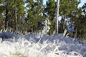 Frosted alpine forest in Constanza.
 -
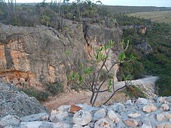 Semi-arid climate in Pedernales.
 -
 Desert sand dunes of Bani.
_Saman%C3%A1,_DR.JPG)

.JPG)

Islands
[edit]
There are several smaller islands and cays that are part of Dominican territory. The largest islands are:
- Saona, close to the southeastern coast of Hispaniola, in the Caribbean Sea. It has an area of 117 km2.[4] Its Taíno name was Iai [7] or Adamanay. Columbus named this island as Savona, after the Italian city of the same name, but the use during years has eliminated the letter v.
- Beata, also on the southern coast. It has an area of 27 km2.[4] Its Taíno name is unknown. Columbus named this island Madama Beata.
- Catalina, very close to the southeastern coast. It has an area of 9.6 km2.[4] Its Taíno name was Iabanea[7] but some writers, including poets, say that it was called Toeya or Toella.
Rivers and lakes
[edit]

The 8 longest rivers of the Dominican Republic are:[8]
- Yaque del Norte. At 296 km, it is the longest river in the Dominican Republic. Its sources are in the Cordillera Central and flows to the Atlantic Ocean. Its watershed has an area of 7,044 km2.
- Yuna. It is 185 km long. Its sources are in the Cordillera Central and flows to the east into Samaná Bay. Its watershed has an area of 5,498 km2.
- Yaque del Sur. It is 183 km long and its sources are in the Cordillera Central. It flows to the south into the Caribbean Sea. Its watershed has an area of 4,972 km2.
- Ozama. It is 148 km long. Its sources are in Sierra de Yamasá (a branch of the Cordillera Central). It flows into the Caribbean Sea. Its watershed has an area of 2,685 km2.
- Camú. It is 137 km long. Its sources are in the Cordillera Central and flows into the Yuna River. Its watershed has 2,655 km2.
- Nizao. It is 133 km long. Its sources are in the Cordillera Central and flows to the south into the Caribbean Sea. Its watershed has an area of 974 km2.
- San Juan. It is 121 km long. Its sources are in the Cordillera Central and flows to the south into the Yaque del Sur River. Its watershed has an area of 2,005 km2.
- Mao. It is 105 km long. Its sources are in the Cordillera Central and flows to the north into the Yaque del Norte River. Its watershed has an area of 864 km2.
The Artibonite River is the longest river of the island, but only 68 km flows through the Dominican Republic.
The largest lake of Hispaniola, and of the Caribbean, is Lake Enriquillo. It is located in the Hoya de Enriquillo with an area of 265 km2. There are three small islands within the lake. It is around 40 meters below sea level, and is a hypersaline lake, with a higher concentration of salt than seawater.
Other lakes are Rincón (fresh water, area of 28.2 km2), Oviedo (brackish water, area of 28 km2), Redonda, and Limón.
Statistics
[edit]
- Location
- Caribbean, it occupies five-eighths of the island of Hispaniola, between the Caribbean Sea and the North Atlantic Ocean, east of Haiti
- Geographic coordinates
- 19°00′N 70°40′W / 19.000°N 70.667°W
- Area
-
- Total: 48,670 km²
- Land: 48,320 km²
- Water: 350 km²
- Coastline
- 1,288 km
- Maritime claims
-
- Territorial sea: 6 nmi (11.1 km; 6.9 mi)
- Contiguous zone: 24 nmi (44.4 km; 27.6 mi)
- Exclusive economic zone: 255,898 km2 (98,803 sq mi) with 200 nmi (370.4 km; 230.2 mi)
- Continental shelf: 200 nmi (370.4 km; 230.2 mi) or to the edge of the continental margin
- Climate
- Tropical maritime; little seasonal temperature variation; seasonal variation in rainfall
- Rivers
- Significant rivers include the Jimani River, Río Yaque del Norte, Río Jamao del Norte, Río Isabela and the Ozama River

- Terrain
- Rugged highlands and mountains with fertile valleys interspersed
- Geographical extremes
-
- Northernmost point – Cabo Isabela
- Southernmost point – Alto Velo Island, Jaragua National Park
- Southernmost point (mainland) – south of Oviedo, Pedernales in Jaragua National Park
- Westernmost point – Las Lajas, border with Haiti, Independencia Province
- Easternmost point – Punta de Agua, La Altagracia Province
- Elevation extremes
-
- Lowest point – Lago Enriquillo: -46 m
- Highest point – Pico Duarte: 3,098 m
- Natural resources
- Nickel, bauxite, gold, silver
- Land use
-
- Arable land: 16.56%
- Permanent crops: 10.35%
- Other: 73.10% (2012 est.)
- Irrigated land
- 3,241 km² (2018)
- Total renewable water resources
- 21 km3 (2011)
- Freshwater withdrawal (domestic/industrial/agricultural)
-
- total: 5.47 km3/yr (26%/1%/72%)
- per capita: 574.2 m3/yr (2005)
- Natural hazards
- Lies in the middle of the hurricane belt and subject to severe storms from June to October; occasional flooding; periodic droughts
- Environment - current issues
- Water shortages; soil eroding into the sea damages coral reefs; deforestation; damage caused by Hurricane Georges
- Environment - international agreements
-
- Party to: Biodiversity, Climate Change, Desertification, Endangered Species, Marine Dumping, Marine Life Conservation, Nuclear Test Ban, Ozone Layer Protection, Ship Pollution, Wetlands
- Signed, but not ratified: Law of the Sea
- Geography - note
- Shares island of Hispaniola with Haiti (eastern five-eighths is the Dominican Republic, western three-eighths is Haiti)[1][2]
References
[edit]- ^ a b Dardik, Alan, ed. (2016). Vascular Surgery: A Global Perspective. Springer. p. 341. ISBN 9783319337456. Retrieved 8 May 2017.
- ^ a b Josh, Jagran, ed. (2016). "Current Affairs November 2016 eBook". p. 93. Retrieved 8 May 2017.
- ^ "CIA World Factbook: Haiti". 12 July 2022.
- ^ a b c d De la Fuente, Santiago (1976). Geografía Dominicana. Santo Domingo, Dominican Republic: Editora Colegial Quisqueyana. pp. 90–92.
- ^ "Dominican Republic| History, Geography, & Culture". Encyclopædia Britannica. Retrieved 2018-02-21.
- ^ Butterlin, Jacques (1977). Géologie Structural de la Région des Caraïbes (in French). Paris: Masson. pp. 110–111. ISBN 2-225-44979-1.
- ^ a b As shown in a map made by Andrés Morales in 1508 and published in 1516. In Vega, Bernardo (1989). Los Cacicazgos de la Hispaniola. Santo Domingo, Dominican Republic: Museo del Hombre Dominicano. p. 88.
- ^ De la Fuente, Santiago (1976). Geografía Dominicana. Santo Domingo, Dominican Republic: Editora Colegial Quisqueyana. pp. 110–114.
| Sovereign states |  | |
|---|---|---|
Dependencies and other territories | ||