
Horseshoe Falls: Difference between revisions
No edit summary |
Citation bot (talk | contribs) Added date. | Use this bot. Report bugs. | Suggested by Dominic3203 | Category:Use mdy dates from September 2016 | #UCB_Category 172/954 |
||
| (7 intermediate revisions by 4 users not shown) | |||
| Line 21: | Line 21: | ||
}} |
}} |
||
'''Horseshoe Falls''' is the largest of the three waterfalls that collectively form [[Niagara Falls]] on the [[Niagara River]] along the [[Canada–United States border]]. Approximately 90% of the Niagara River, after diversions for [[Hydroelectricity|hydropower generation]], flows over Horseshoe Falls. The remaining 10% flows over [[American Falls]] and [[Bridal Veil Falls (Niagara Falls)|Bridal Veil Falls]]. It is located between [[Terrapin Point]] on [[Goat Island (New York)|Goat Island]] in the [[United States|US]] state of [[New York (state)|New York]], and [[Table Rock, Niagara Falls|Table Rock]] in the [[Provinces and territories of Canada|Canadian province]] of [[Ontario]].<ref name="1911hearings">"The international boundary line may pass through the Horseshoe Falls just beyond Terrapin Tower Point, so that the United States are not entitled to as large a portion as Canada of the Horseshoe Falls, which is admittedly not all Canadian." Statement of Mr. J Boardman Scovell. ''Preservation of Niagara Falls: hearings on the subject of H.R. 26688, Sixty-first Congress, second session, relating to the control and regulation of the waters of Niagara River and the preservation of Niagara Falls, held before the Committee on Rivers and Harbors of the House of Representatives.'' U.S. G.P.O., 1911</ref> These falls are also referred to as the '''Canadian Falls''.<ref> {{cite web |url= http://www.infoniagara.com/attractions/canadian_falls/ |publisher= Info Niagara |title= |
'''Horseshoe Falls''' is the largest of the three waterfalls that collectively form [[Niagara Falls]] on the [[Niagara River]] along the [[Canada–United States border]]. Approximately 90% of the Niagara River, after diversions for [[Hydroelectricity|hydropower generation]], flows over Horseshoe Falls. The remaining 10% flows over [[American Falls]] and [[Bridal Veil Falls (Niagara Falls)|Bridal Veil Falls]]. It is located between [[Terrapin Point]] on [[Goat Island (New York)|Goat Island]] in the [[United States|US]] state of [[New York (state)|New York]], and [[Table Rock, Niagara Falls|Table Rock]] in the [[Provinces and territories of Canada|Canadian province]] of [[Ontario]].<ref name="1911hearings">"The international boundary line may pass through the Horseshoe Falls just beyond Terrapin Tower Point, so that the United States are not entitled to as large a portion as Canada of the Horseshoe Falls, which is admittedly not all Canadian." Statement of Mr. J Boardman Scovell. ''Preservation of Niagara Falls: hearings on the subject of H.R. 26688, Sixty-first Congress, second session, relating to the control and regulation of the waters of Niagara River and the preservation of Niagara Falls, held before the Committee on Rivers and Harbors of the House of Representatives.'' U.S. G.P.O., 1911</ref> These falls are also referred to as the '''Canadian Falls'''.<ref> {{cite web |url= http://www.infoniagara.com/attractions/canadian_falls/ |publisher= Info Niagara |title= Canadian Falls |date= 2021 }} </ref><ref> {{cite book |chapter= Niagara Falls (Waterfalls) |title= The Canadian Encyclopedia |url= https://www.thecanadianencyclopedia.ca/en/article/niagara-falls#recommended |date= 22 April 2013 }} </ref> |
||
==International border== |
==International border== |
||
[[File:Niagara-boundary-1819.jpg|right|thumb|1819 Boundary Commission map of the International Boundary Line cutting through Horseshoe Falls]] |
[[File:Niagara-boundary-1819.jpg|right|thumb|1819 Boundary Commission map of the International Boundary Line cutting through Horseshoe Falls]] |
||
When the boundary line between the United States and Canada was determined in 1819, based on the [[Treaty of Ghent]], the northeastern end of the Horseshoe Falls was in [[New York (state)|New York]], United States, flowing around the Terrapin Rocks, which were once connected to [[Goat Island (New York)|Goat Island]] by a series of bridges. In 1955, the area between the rocks and Goat Island was filled in, creating [[Terrapin Point]].<ref name=berton>{{cite book |last= Berton |first= Pierre |title= Niagara: A History of the Falls |url= https://books.google.com/books?id=P_Rr06A2H6UC&pg=PA20 |access-date= December 1, 2010 |year= 2009 |publisher= SUNY Press |isbn= 978-1-4384-2928-1 |pages=20–21}}</ref> In the early 1980s the [[United States Army Corps of Engineers]] filled in more land and built diversion dams and retaining walls to force the water away from Terrapin Point. Altogether, {{convert|400|ft|m|abbr=on}} of the Horseshoe Falls was eliminated. Due to erosion, the |
When the boundary line between the United States and Canada was determined in 1819, based on the [[Treaty of Ghent]], the northeastern end of the Horseshoe Falls was in [[New York (state)|New York]], United States, flowing around the Terrapin Rocks, which were once connected to [[Goat Island (New York)|Goat Island]] by a series of bridges. In 1955, the area between the rocks and Goat Island was filled in, creating [[Terrapin Point]].<ref name=berton>{{cite book |last= Berton |first= Pierre |title= Niagara: A History of the Falls |url= https://books.google.com/books?id=P_Rr06A2H6UC&pg=PA20 |access-date= December 1, 2010 |year= 2009 |publisher= SUNY Press |isbn= 978-1-4384-2928-1 |pages=20–21}}</ref> In the early 1980s the [[United States Army Corps of Engineers]] filled in more land and built diversion dams and retaining walls to force the water away from Terrapin Point. Altogether, {{convert|400|ft|m|abbr=on}} of the Horseshoe Falls was eliminated. Due to erosion, the Falls will continue to move in relation to the boundary line in the future, possibly altering territorial boundaries between the two countries. |
||
The official national maps for both Canada and the United States indicate that a smaller portion of the Horseshoe Falls is located within the United States.<ref>{{cite web | title = The Atlas of Canada | publisher = Government of Canada |url=http://atlas.gc.ca/toporama/en/index.html?id=map1&extent=1317001.3341982635,-501305.9605510465,1318807.9128114209,-500353.4586460427&legend=762eb7ed-0001-242f-6fcf-af08f5605eb1,0,0,1;e5511402-0002-5cbe-0d3c-f537c612b7df,0,0,0.7;cc7fde4c-0003-1cf2-8358-7ca86eefb13c,0,0,1;762eb7ed-cccc-242f-6fcf-af08f5605eb1,0,1,1;8a57b0ba-c004-f03d-7cd4-b3d9b35a8b83,0,0,1;4118b52e-66fe-6b4d-b826-a8f309338f76,0,0,1;e5511402-0029-5cbe-0d3c-f537c612b7dg,0,0,1;e5511402-0029-5cbe-0d3c-f537c612b7df,0,1,1;e5511402-0028-5cbe-0d3c-f537c612b7df,0,0,1;e5511402-0628-5cbe-0d3c-f537c612b7df,0,1,1;e5511402-0528-5cbe-0d3c-f537c612b7df,0,1,1;8a9bb0ab-0005-32b1-6715-be42194945aa,0,0,1;e5511402-0027-5cbe-0d3c-f537c612b7df,0,1,1;e5511402-0026-5cbe-0d3c-f537c612b7df,0,1,1;e5511402-0025-5cbe-0d3c-f537c612b7df,0,1,1;8a9bb0ab-0021-32b1-6715-be42194945aa,0,1,1;e5511402-0023-5cbe-0d3c-f537c612b7df,0,1,1;e5511402-0022-5cbe-0d3c-f537c612b7df,0,1,1;8a9bb0ab-0018-32b1-6715-be42194945aa,0,1,1;e5511402-0020-5cbe-0d3c-f537c612b7df,0,1,1;e5511402-0019-5cbe-0d3c-f537c612b7df,0,1,1;8a9bb0ab-0014-32b1-6715-be42194945aa,0,1,1;e5511402-0017-5cbe-0d3c-f537c612b7df,0,1,1;e5511402-0016-5cbe-0d3c-f537c612b7df,0,1,1;e5511402-0015-5cbe-0d3c-f537c612b7df,0,1,1;8a9bb0ab-0010-32b1-6715-be42194945aa,0,1,1;e5511402-0013-5cbe-0d3c-f537c612b7df,0,1,1;e5511402-0012-5cbe-0d3c-f537c612b7df,0,1,1;e5511402-0011-5cbe-0d3c-f537c612b7de,0,1,1;e5511402-0011-5cbe-0d3c-f537c612b7df,0,1,1;e5511402-0009-5cbe-0d3c-f537c612b7df,0,1,1;e5511402-0007-5cbe-0d3c-f537c612b7df,0,1,1;e5511402-0004-5cbe-0d3c-f537c612b7df,0,1,1 | access-date = February 19, 2017}}</ref><ref>{{cite web | title = National Map of the United States | publisher = United States Geological Survey | url = https://viewer.nationalmap.gov/basic/?basemap=b1&category=nbd,ned,nedsrc,histtopo,nhd,hro,naip,nbdmi,gnis,nlcd,smallscale,nsd,vectorcmb,ntd,ustopo,woodland&q=&zoom=17&bbox=-79.07926798,43.07932680,-79.07132864,43.08171686&preview=&avail=&refpoly= | access-date = February 19, 2017}}</ref> |
The official national maps for both Canada and the United States indicate that a smaller portion of the Horseshoe Falls currently is located within the United States.<ref>{{cite web | title = The Atlas of Canada | date = September 12, 2016 | publisher = Government of Canada |url=http://atlas.gc.ca/toporama/en/index.html?id=map1&extent=1317001.3341982635,-501305.9605510465,1318807.9128114209,-500353.4586460427&legend=762eb7ed-0001-242f-6fcf-af08f5605eb1,0,0,1;e5511402-0002-5cbe-0d3c-f537c612b7df,0,0,0.7;cc7fde4c-0003-1cf2-8358-7ca86eefb13c,0,0,1;762eb7ed-cccc-242f-6fcf-af08f5605eb1,0,1,1;8a57b0ba-c004-f03d-7cd4-b3d9b35a8b83,0,0,1;4118b52e-66fe-6b4d-b826-a8f309338f76,0,0,1;e5511402-0029-5cbe-0d3c-f537c612b7dg,0,0,1;e5511402-0029-5cbe-0d3c-f537c612b7df,0,1,1;e5511402-0028-5cbe-0d3c-f537c612b7df,0,0,1;e5511402-0628-5cbe-0d3c-f537c612b7df,0,1,1;e5511402-0528-5cbe-0d3c-f537c612b7df,0,1,1;8a9bb0ab-0005-32b1-6715-be42194945aa,0,0,1;e5511402-0027-5cbe-0d3c-f537c612b7df,0,1,1;e5511402-0026-5cbe-0d3c-f537c612b7df,0,1,1;e5511402-0025-5cbe-0d3c-f537c612b7df,0,1,1;8a9bb0ab-0021-32b1-6715-be42194945aa,0,1,1;e5511402-0023-5cbe-0d3c-f537c612b7df,0,1,1;e5511402-0022-5cbe-0d3c-f537c612b7df,0,1,1;8a9bb0ab-0018-32b1-6715-be42194945aa,0,1,1;e5511402-0020-5cbe-0d3c-f537c612b7df,0,1,1;e5511402-0019-5cbe-0d3c-f537c612b7df,0,1,1;8a9bb0ab-0014-32b1-6715-be42194945aa,0,1,1;e5511402-0017-5cbe-0d3c-f537c612b7df,0,1,1;e5511402-0016-5cbe-0d3c-f537c612b7df,0,1,1;e5511402-0015-5cbe-0d3c-f537c612b7df,0,1,1;8a9bb0ab-0010-32b1-6715-be42194945aa,0,1,1;e5511402-0013-5cbe-0d3c-f537c612b7df,0,1,1;e5511402-0012-5cbe-0d3c-f537c612b7df,0,1,1;e5511402-0011-5cbe-0d3c-f537c612b7de,0,1,1;e5511402-0011-5cbe-0d3c-f537c612b7df,0,1,1;e5511402-0009-5cbe-0d3c-f537c612b7df,0,1,1;e5511402-0007-5cbe-0d3c-f537c612b7df,0,1,1;e5511402-0004-5cbe-0d3c-f537c612b7df,0,1,1 | access-date = February 19, 2017}}</ref><ref>{{cite web | title = National Map of the United States | publisher = United States Geological Survey | url = https://viewer.nationalmap.gov/basic/?basemap=b1&category=nbd,ned,nedsrc,histtopo,nhd,hro,naip,nbdmi,gnis,nlcd,smallscale,nsd,vectorcmb,ntd,ustopo,woodland&q=&zoom=17&bbox=-79.07926798,43.07932680,-79.07132864,43.08171686&preview=&avail=&refpoly= | access-date = February 19, 2017}}</ref> |
||
==Gallery== |
==Gallery== |
||
| Line 35: | Line 35: | ||
File:Horseshoe Falls, viewed from Table Rock Centre in Niagara Falls, Ontario.jpg|Horseshoe Falls, viewed from [[Table Rock Welcome Centre|Table Rock Centre]] in [[Niagara Falls, Ontario]] |
File:Horseshoe Falls, viewed from Table Rock Centre in Niagara Falls, Ontario.jpg|Horseshoe Falls, viewed from [[Table Rock Welcome Centre|Table Rock Centre]] in [[Niagara Falls, Ontario]] |
||
File:Behind Horseshoe Falls from the Canadian side.jpg|alt=from a platform behind the falls.|View from beside and behind Horseshoe Falls |
File:Behind Horseshoe Falls from the Canadian side.jpg|alt=from a platform behind the falls.|View from beside and behind Horseshoe Falls |
||
File:Horseshoe Falls 2017.ogg|Horseshoe Falls, viewed from the Maid of the Mist tour boat |
File:Horseshoe Falls 2017.ogg|Horseshoe Falls, viewed from the [[Maid of the Mist]] tour boat |
||
File:Horseshoefallsonel.jpg|A view of Horseshoe Falls with the Canadian flag at night |
File:Horseshoefallsonel.jpg|A view of Horseshoe Falls with the Canadian flag at night |
||
</gallery> |
</gallery> |
||
| Line 49: | Line 49: | ||
{{Reflist}} |
{{Reflist}} |
||
{{Niagara Falls}} |
|||
[[Category:Niagara Falls]] |
[[Category:Niagara Falls]] |
||
Revision as of 00:56, 9 May 2024
| Horseshoe Falls | |
|---|---|
_and_the_Hornblower_Niagara_Cruises_boat;_Niagara_Falls.JPG) | |
 | |
| Location | Border of Ontario, Canada, and New York, United States. Canada to the right in the photo. |
| Coordinates | 43°04′38″N 79°04′32″W / 43.077305°N 79.07562°W |
| Type | Cataract |
| Total height | 167 ft (51 m)[1] |
| Total width | 2,700 ft (820 m)[1] |
| Watercourse | Niagara River |
Horseshoe Falls is the largest of the three waterfalls that collectively form Niagara Falls on the Niagara River along the Canada–United States border. Approximately 90% of the Niagara River, after diversions for hydropower generation, flows over Horseshoe Falls. The remaining 10% flows over American Falls and Bridal Veil Falls. It is located between Terrapin Point on Goat Island in the US state of New York, and Table Rock in the Canadian province of Ontario.[2] These falls are also referred to as the Canadian Falls.[3][4]
International border

When the boundary line between the United States and Canada was determined in 1819, based on the Treaty of Ghent, the northeastern end of the Horseshoe Falls was in New York, United States, flowing around the Terrapin Rocks, which were once connected to Goat Island by a series of bridges. In 1955, the area between the rocks and Goat Island was filled in, creating Terrapin Point.[5] In the early 1980s the United States Army Corps of Engineers filled in more land and built diversion dams and retaining walls to force the water away from Terrapin Point. Altogether, 400 ft (120 m) of the Horseshoe Falls was eliminated. Due to erosion, the Falls will continue to move in relation to the boundary line in the future, possibly altering territorial boundaries between the two countries.
The official national maps for both Canada and the United States indicate that a smaller portion of the Horseshoe Falls currently is located within the United States.[6][7]
Gallery
-
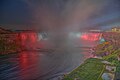 Horseshoe Falls at night
 -
 Horseshoe Falls, viewed from Table Rock Centre in Niagara Falls, Ontario
 -
 View from beside and behind Horseshoe Falls
 -
Horseshoe Falls, viewed from the Maid of the Mist tour boat
-
 A view of Horseshoe Falls with the Canadian flag at night


See also
References
- ^ a b "Niagara Falls". World Waterfalls Database. Retrieved January 28, 2017.
- ^ "The international boundary line may pass through the Horseshoe Falls just beyond Terrapin Tower Point, so that the United States are not entitled to as large a portion as Canada of the Horseshoe Falls, which is admittedly not all Canadian." Statement of Mr. J Boardman Scovell. Preservation of Niagara Falls: hearings on the subject of H.R. 26688, Sixty-first Congress, second session, relating to the control and regulation of the waters of Niagara River and the preservation of Niagara Falls, held before the Committee on Rivers and Harbors of the House of Representatives. U.S. G.P.O., 1911
- ^ "Canadian Falls". Info Niagara. 2021.
- ^ "Niagara Falls (Waterfalls)". The Canadian Encyclopedia. April 22, 2013.
- ^ Berton, Pierre (2009). Niagara: A History of the Falls. SUNY Press. pp. 20–21. ISBN 978-1-4384-2928-1. Retrieved December 1, 2010.
- ^ "The Atlas of Canada". Government of Canada. September 12, 2016. Retrieved February 19, 2017.
- ^ "National Map of the United States". United States Geological Survey. Retrieved February 19, 2017.