
Trnovo, Republika Srpska: Difference between revisions
No edit summary |
c/e. regional subdivisions are always ordered from smallest to largest (i.e. "San Bruno, California, United States", etc.) |
||
| (41 intermediate revisions by 24 users not shown) | |||
| Line 1: | Line 1: | ||
{{distinguish|Trnovo, Federation of Bosnia and Herzegovina}} |
{{distinguish|Trnovo, Federation of Bosnia and Herzegovina}}{{For|other places with the same name|Trnovo (disambiguation){{!}}Trnovo}} |
||
{{Expand Serbian|Општина Трново (Источно Сарајево)|date=April 2015}} |
|||
{{Infobox settlement <!--more fields are available for this Infobox--See Template:Infobox Settlement--> |
{{Infobox settlement <!--more fields are available for this Infobox--See Template:Infobox Settlement--> |
||
|name = Trnovo |
| name = Trnovo |
||
|native_name = Трново |
| native_name = Трново |
||
|native_name_lang = |
| native_name_lang = |
||
|other_name = |
| other_name = |
||
|settlement_type = |
| settlement_type = [[Municipalities of Republika Srpska|Municipality]] |
||
|official_name = |
| official_name = |
||
|nickname = |
| nickname = |
||
|motto = |
| motto = |
||
|subdivision_type = [[ |
| subdivision_type = [[List of sovereign states|Country]] |
||
|subdivision_name = {{Flag|Bosnia and Herzegovina}} |
| subdivision_name = {{Nowrap|{{Flag|Bosnia and Herzegovina}}}} |
||
|subdivision_type1 = [[ |
| subdivision_type1 = [[Political divisions of Bosnia and Herzegovina|Entity]] |
||
|subdivision_name1 = {{ |
| subdivision_name1 = {{Nowrap|{{Flag|Republika Srpska}}}} |
||
|subdivision_type2 = |
| subdivision_type2 = [[List of cities in Bosnia and Herzegovina|City]] |
||
| subdivision_name2 = {{flagicon image|Flag of East Sarajevo.svg|size=23px}} [[Istočno Sarajevo]] |
|||
|subdivision_name2 = |
|||
|image_skyline = |
| image_skyline = Trnovo RS IMG 0908.jpg |
||
| image_flag = Застава Трнова.png |
|||
|timezone = [[Central European Time|CET]] |
|||
| |
| flag_size = 150px |
||
| |
| timezone = [[Central European Time|CET]] |
||
| |
| utc_offset = +1 |
||
| timezone_DST = [[Central European Summer Time|CEST]] |
|||
|unit_pref = |
|||
| utc_offset_DST = +2 |
|||
|map_caption = Location of Trnovo within Bosnia and Herzegovina |
|||
| |
| unit_pref = Metric |
||
| map_caption = Location of Trnovo, Republika Srpska within Bosnia and Herzegovina. |
|||
|population_as_of = 2013 census |
|||
| coordinates = {{coord|43|39|56|N|18|26|47|E|region:BA_type:city|display=inline, title}} |
|||
|image_shield = |
|||
| population_as_of = 2013 census |
|||
|image_map = Trnovo (Republika Srpska) municipality.svg |
|||
| image_shield = |
|||
|area_total_km2 =138 |
|||
| image_map = Trnovo (Republika Srpska) municipality.svg |
|||
|population_total =2192 |
|||
| |
| area_total_km2 = 138 |
||
| |
| population_total = 2050 |
||
| |
| area_code = 57 |
||
| website = {{url|http://www.trnovo-rs.com}} |
|||
| leader_title = Municipal mayor |
|||
| leader_name = Dragomir Gagović |
|||
| leader_party = [[Alliance of Independent Social Democrats|SNSD]] |
|||
| image_map1 = Trnovo-naselja.PNG |
|||
}} |
}} |
||
'''Trnovo''' ({{lang-sr-cyr|Трново}}) is a municipality of the city of [[Istočno Sarajevo]] |
'''Trnovo''' ({{lang-sr-cyr|Трново}}) is a municipality of the city of [[Istočno Sarajevo]], [[Republika Srpska]], [[Bosnia and Herzegovina]]. |
||
As of 2013, the municipality had a population of 2,050 inhabitants. The town itself had a total population of 1,023, with 956 of them living in the Republika Srpska part<ref>{{cite web|title=Naseljena Mjesta 1991/2013|url=http://www.statistika.ba/?show=12&id=20591|publisher=Statistical Office of Bosnia and Herzegovina|accessdate=March 12, 2022|language=Bosnian}}</ref> and 67 in the Federation part.<ref>{{cite web|title=Naseljena Mjesta 1991/2013|url=http://www.statistika.ba/?show=12&id=11592|publisher=Statistical Office of Bosnia and Herzegovina|accessdate=March 12, 2022|language=Bosnian}}</ref> |
|||
It consists of roughly one third of the [[Bosnian War|pre-war]] municipality of [[Trnovo, Bosnia and Herzegovina|Trnovo]]. Roughly two thirds of the pre-war [[Trnovo, Federation of Bosnia and Herzegovina|Trnovo]] municipality is now part of the [[Federation of Bosnia and Herzegovina]] entity. |
It consists of roughly one third of the [[Bosnian War|pre-war]] municipality of [[Trnovo, Bosnia and Herzegovina|Trnovo]]. Roughly two thirds of the pre-war [[Trnovo, Federation of Bosnia and Herzegovina|Trnovo]] municipality is now part of the [[Federation of Bosnia and Herzegovina]] entity. |
||
| Line 41: | Line 47: | ||
Trnovo is situated south of [[Sarajevo]] on the M-18 road [[Sarajevo]]-Trnovo-[[Foča]]-[[Trebinje]]. It is surrounded by the [[Jahorina]], [[Bjelašnica]] and [[Treskavica]] mountains which were the locations of Olympic competitions during the [[1984 Winter Olympics]]. Those mountains are popular destinations for a variety of winter sports and activities.<ref>[http://www.oc-jahorina.com/ Jahorina official website]; accessed 13 December 2015.</ref> |
Trnovo is situated south of [[Sarajevo]] on the M-18 road [[Sarajevo]]-Trnovo-[[Foča]]-[[Trebinje]]. It is surrounded by the [[Jahorina]], [[Bjelašnica]] and [[Treskavica]] mountains which were the locations of Olympic competitions during the [[1984 Winter Olympics]]. Those mountains are popular destinations for a variety of winter sports and activities.<ref>[http://www.oc-jahorina.com/ Jahorina official website]; accessed 13 December 2015.</ref> |
||
The [[Željeznica ( |
The [[Željeznica (Bosna)|Željeznica]] river is one of the town's chief geographic features. It flows through the town and municipality from south through the center of Trnovo, [[Kijevo, Trnovo|Kijevo]] and [[Istočno Sarajevo|East Sarajevo]] to west part of [[Sarajevo|Sarajevo City]] eventually meets with the [[Bosna (river)|Bosna]] river.{{cn|date=December 2015}} |
||
== |
==Settlements== |
||
Aside from the town of Trnovo, the municipality includes the following settlements:<ref>{{cite web|author=Министарство управе и локалне самоуправе Републике Српске|title=Уредба о насељеним мјестима која чине подручје јединице локалне самоуправе|publisher=Влада Републике Српске|url=http://www.vladars.net/sr-SP-Cyrl/Vlada/Ministarstva/muls/media/Aktuelnosti/Documents/Uredba%20o%20naseljenim%20mjestima.doc}}</ref> |
|||
[[File:Trnovo in former Yugoslavia 1996.JPEG|thumb|Ruined Trnovo, 9 October 1996.]] |
|||
{{div col|colwidth=22em}} |
|||
* [[Bašci]] |
|||
==Villages== |
|||
* [[Bistročaj]] |
|||
The following villages are part of Trnovo (RS):<ref>{{cite document|author=Министарство управе и локалне самоуправе Републике Српске|title=Уредба о насељеним мјестима која чине подручје јединице локалне самоуправе|publisher=Влада Републике Српске|url=http://www.vladars.net/sr-SP-Cyrl/Vlada/Ministarstva/muls/media/Aktuelnosti/Documents/Uredba%20o%20naseljenim%20mjestima.doc}}</ref> |
|||
* [[Bogatići]] |
|||
* [[Boljanovići, Trnovo|Boljanovići]] |
|||
• [[Bistročaj]] |
|||
* [[Divčići]] |
|||
* [[Donja Presjenica]] |
|||
• [[Boljanovići, Trnovo|Boljanovići]] |
|||
* [[Govedovići, Trnovo|Govedovići]] |
|||
• [[Divčići]] |
|||
* [[Grab, Trnovo|Grab]] |
|||
* [[Gračanica, Trnovo|Gračanica]] |
|||
• [[Godinja]] |
|||
* [[Ilovice]] |
|||
• [[Govedovići, Trnovo|Govedovići]] |
|||
* [[Jablanica, Trnovo|Jablanica]] |
|||
* [[Kijevo, Trnovo|Kijevo]] |
|||
* [[Klanac, Trnovo|Klanac]] |
|||
• [[Ilovice]] |
|||
* [[Kozija Luka]] |
|||
• [[Jablanica, Trnovo|Jablanica]] |
|||
* [[Milje, Trnovo|Milje]] |
|||
* [[Podivič]] |
|||
• [[Klanac, Trnovo|Klanac]] |
|||
* [[Rajski Do]] |
|||
* [[Slavljevići]] |
|||
• [[Milje, Trnovo|Milje]] |
|||
* [[Tošići]] |
|||
* [[Turovi]] |
|||
* [[Ulobići]] |
|||
* [[Vrbovnik]] |
|||
* [[Zabojska]] |
|||
• '''Trnovo''' |
|||
{{div col end}} |
|||
• [[Turovi]] |
|||
• [[Ulobići]] |
|||
• [[Vrbovnik]] |
|||
• [[Zabojska]] |
|||
==Demographics== |
==Demographics== |
||
The pre-war municipality, with 63 settlements, had a total population of 6,991 people, of whom Muslims |
The pre-war municipality, with 63 settlements, had a total population of 6,991 people, of whom Muslims consisted 68.81% and Serbs 29.45% of total population. Most of the Serb-inhabited settlements became part of the Trnovo municipality of Republika Srpska ({{abbreviation|RS|Republika Srpska}}). The 2013 census preliminary results counted 2,192 inhabitants of the municipality of Trnovo in RS, and 1,018 in the settlement of Trnovo in RS. |
||
=== Population === |
|||
{| class="wikitable" |
|||
! colspan="6" |Population of settlements – Trnovo (RS) municipality |
|||
|- |
|||
| |
|||
|Settlement |
|||
|1971. |
|||
|1981. |
|||
|1991. |
|||
|2013. |
|||
|- |
|||
| |
|||
|Total |
|||
|9,555 |
|||
|8,161 |
|||
|6,991 |
|||
|2,050 |
|||
|- |
|||
|1 |
|||
|Jablanica |
|||
| |
|||
| |
|||
|435 |
|||
|257 |
|||
|- |
|||
|2 |
|||
|Kijevo |
|||
| |
|||
| |
|||
|452 |
|||
|269 |
|||
|- |
|||
|3 |
|||
|Tošići |
|||
| |
|||
| |
|||
|391 |
|||
|259 |
|||
|- |
|||
|4 |
|||
|'''Trnovo''' |
|||
|765 |
|||
|1,403 |
|||
|2,099 |
|||
|1,018 |
|||
|} |
|||
=== Ethnic composition === |
|||
{| class="wikitable" |
|||
! colspan="8" |Ethnic composition – Trnovo (RS) town |
|||
|- |
|||
| |
|||
|2013.[http://www.statistika.ba/?show=12&id=20591] |
|||
|1991. |
|||
|1981. |
|||
|1971. |
|||
|- |
|||
|Total |
|||
|956 (100,0%) |
|||
|2,099 (100,0%) |
|||
|1,403 (100,0%) |
|||
|765 (100,0%) |
|||
|- |
|||
|Bosniaks |
|||
|234 (24,5%) |
|||
|1,078 (51,36%) |
|||
|552 (39,34%) |
|||
|233 (30,46%) |
|||
|- |
|||
|Serbs |
|||
|705 (73,7%) |
|||
|939 (44,74%) |
|||
|737 (52,53%) |
|||
|506 (66,14%) |
|||
|- |
|||
|Yugoslavs |
|||
| |
|||
|46 (2,192%) |
|||
|91 (6,486%) |
|||
|1 (0,131%) |
|||
|- |
|||
|Others |
|||
|10 (1,0%) |
|||
|22 (1,048%) |
|||
|2 (0,143%) |
|||
| |
|||
|- |
|||
|Croats |
|||
|7 (0,7%) |
|||
|14 (0,667%) |
|||
|8 (0,570%) |
|||
|17 (2,222%) |
|||
|- |
|||
|Montenegrins |
|||
| |
|||
| |
|||
|13 (0,927%) |
|||
|7 (0,915%) |
|||
|- |
|||
|Slovenes |
|||
| |
|||
| |
|||
| |
|||
|1 (0,131%) |
|||
|} |
|||
{| class="wikitable" |
|||
! colspan="8" |Ethnic composition – Trnovo (RS) municipality |
|||
|- |
|||
| |
|||
|2013. |
|||
|1991. |
|||
|1981. |
|||
|1971. |
|||
|- |
|||
|Total |
|||
|2,050 (100,0%) |
|||
|6,991 (100,0%) |
|||
|8,161 (100,0%) |
|||
|9,555 (100,0%) |
|||
|- |
|||
|Serbs |
|||
|1,178 (57,46%) |
|||
|2,059 (29,45%) |
|||
|2,242 (27,47%) |
|||
|3,093 (32,37%) |
|||
|- |
|||
|Bosniaks |
|||
|837 (40,83%) |
|||
|4,790 (68,52%) |
|||
|5,693 (69,76%) |
|||
|6,342 (66,37%) |
|||
|- |
|||
|Others |
|||
|20 (0,976%) |
|||
|54 (0,772%) |
|||
|22 (0,270%) |
|||
|40 (0,419%) |
|||
|- |
|||
|Croats |
|||
|15 (0,732%) |
|||
|16 (0,229%) |
|||
|19 (0,233%) |
|||
|50 (0,523%) |
|||
|- |
|||
|Yugoslavs |
|||
| |
|||
|72 (1,030%) |
|||
|163 (1,997%) |
|||
|12 (0,126%) |
|||
|- |
|||
|Montenegrins |
|||
| |
|||
| |
|||
|19 (0,233%) |
|||
|17 (0,178%) |
|||
|- |
|||
|Slovenes |
|||
| |
|||
| |
|||
|3 (0,037%) |
|||
|1 (0,010%) |
|||
|} |
|||
==Gallery== |
|||
<gallery class="center"> |
|||
File:Trnovo in former Yugoslavia 1996.JPEG|Ruined Trnovo after the Bosnian war, 9 October 1996 |
|||
File:Trnovo BH Ilovice Željeznica river dam IMG 1005.jpg|Bogatići Small Hydroelectric Power Station |
|||
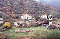
File:Trnovo RS from south viewpt IMG 0898.jpg|Landscape from the area |
|||
File:Trnovo RS north Bogatići IMG 1010.jpg|Road towardsTrnovo |
|||
File:Трново црква 1.jpg|Serbian Orthodox church, built in the 19th century |
|||
File:Trnovo RS south IMG 0891.jpg|Monument dedicated to the Serb victims of the Bosnian war |
|||
</gallery> |
|||
==References== |
==References== |
||
| Line 81: | Line 257: | ||
==External links== |
==External links== |
||
{{ |
{{Commonscat|Trnovo (Republika Srpska)}} |
||
*[http://www.trnovo-rs.com/ Trnovo Municipality, Official Website] |
*[http://www.trnovo-rs.com/ Trnovo Municipality, Official Website] |
||
{{Trnovo (FBIH) municipality}} |
|||
{{Trnovo (RS) municipality}} |
|||
{{Sarajevo}} |
|||
{{Political divisions of Bosnia and Herzegovina}} |
{{Political divisions of Bosnia and Herzegovina}} |
||
{{coord|43|40|N|18|27|E|region:BA_type:city|display=title}} |
|||
[[Category:Populated places in Trnovo, Republika Srpska]] |
[[Category:Populated places in Trnovo, Republika Srpska]] |
||
[[Category:Istočno Sarajevo]] |
[[Category:Istočno Sarajevo]] |
||
[[Category:Cities and towns in Republika Srpska]] |
[[Category:Cities and towns in Republika Srpska]] |
||
[[Category: |
[[Category:Trnovo, Republika Srpska]] |
||
[[Category:Populated places in Trnovo, Sarajevo]] |
|||
Latest revision as of 17:32, 1 March 2024
Trnovo
Трново | |
|---|---|
 | |
 Flag | |
_municipality.svg) Location of Trnovo, Republika Srpska within Bosnia and Herzegovina. | |
 | |
| Coordinates: 43°39′56″N 18°26′47″E / 43.66556°N 18.44639°E | |
| Country | |
| Entity | |
| City | |
| Government | |
| • Municipal mayor | Dragomir Gagović (SNSD) |
| Area | |
| • Total | 138 km2 (53 sq mi) |
| Population (2013 census) | |
| • Total | 2,050 |
| Time zone | UTC+1 (CET) |
| • Summer (DST) | UTC+2 (CEST) |
| Area code | 57 |
| Website | www |
Trnovo (Serbian Cyrillic: Трново) is a municipality of the city of Istočno Sarajevo, Republika Srpska, Bosnia and Herzegovina.
As of 2013, the municipality had a population of 2,050 inhabitants. The town itself had a total population of 1,023, with 956 of them living in the Republika Srpska part[1] and 67 in the Federation part.[2]
It consists of roughly one third of the pre-war municipality of Trnovo. Roughly two thirds of the pre-war Trnovo municipality is now part of the Federation of Bosnia and Herzegovina entity.
Geography
[edit]Trnovo is situated south of Sarajevo on the M-18 road Sarajevo-Trnovo-Foča-Trebinje. It is surrounded by the Jahorina, Bjelašnica and Treskavica mountains which were the locations of Olympic competitions during the 1984 Winter Olympics. Those mountains are popular destinations for a variety of winter sports and activities.[3]
The Željeznica river is one of the town's chief geographic features. It flows through the town and municipality from south through the center of Trnovo, Kijevo and East Sarajevo to west part of Sarajevo City eventually meets with the Bosna river.[citation needed]
Settlements
[edit]Aside from the town of Trnovo, the municipality includes the following settlements:[4]
Demographics
[edit]The pre-war municipality, with 63 settlements, had a total population of 6,991 people, of whom Muslims consisted 68.81% and Serbs 29.45% of total population. Most of the Serb-inhabited settlements became part of the Trnovo municipality of Republika Srpska (RS). The 2013 census preliminary results counted 2,192 inhabitants of the municipality of Trnovo in RS, and 1,018 in the settlement of Trnovo in RS.
Population
[edit]| Population of settlements – Trnovo (RS) municipality | |||||
|---|---|---|---|---|---|
| Settlement | 1971. | 1981. | 1991. | 2013. | |
| Total | 9,555 | 8,161 | 6,991 | 2,050 | |
| 1 | Jablanica | 435 | 257 | ||
| 2 | Kijevo | 452 | 269 | ||
| 3 | Tošići | 391 | 259 | ||
| 4 | Trnovo | 765 | 1,403 | 2,099 | 1,018 |
Ethnic composition
[edit]| Ethnic composition – Trnovo (RS) town | |||||||
|---|---|---|---|---|---|---|---|
| 2013.[1] | 1991. | 1981. | 1971. | ||||
| Total | 956 (100,0%) | 2,099 (100,0%) | 1,403 (100,0%) | 765 (100,0%) | |||
| Bosniaks | 234 (24,5%) | 1,078 (51,36%) | 552 (39,34%) | 233 (30,46%) | |||
| Serbs | 705 (73,7%) | 939 (44,74%) | 737 (52,53%) | 506 (66,14%) | |||
| Yugoslavs | 46 (2,192%) | 91 (6,486%) | 1 (0,131%) | ||||
| Others | 10 (1,0%) | 22 (1,048%) | 2 (0,143%) | ||||
| Croats | 7 (0,7%) | 14 (0,667%) | 8 (0,570%) | 17 (2,222%) | |||
| Montenegrins | 13 (0,927%) | 7 (0,915%) | |||||
| Slovenes | 1 (0,131%) | ||||||
| Ethnic composition – Trnovo (RS) municipality | |||||||
|---|---|---|---|---|---|---|---|
| 2013. | 1991. | 1981. | 1971. | ||||
| Total | 2,050 (100,0%) | 6,991 (100,0%) | 8,161 (100,0%) | 9,555 (100,0%) | |||
| Serbs | 1,178 (57,46%) | 2,059 (29,45%) | 2,242 (27,47%) | 3,093 (32,37%) | |||
| Bosniaks | 837 (40,83%) | 4,790 (68,52%) | 5,693 (69,76%) | 6,342 (66,37%) | |||
| Others | 20 (0,976%) | 54 (0,772%) | 22 (0,270%) | 40 (0,419%) | |||
| Croats | 15 (0,732%) | 16 (0,229%) | 19 (0,233%) | 50 (0,523%) | |||
| Yugoslavs | 72 (1,030%) | 163 (1,997%) | 12 (0,126%) | ||||
| Montenegrins | 19 (0,233%) | 17 (0,178%) | |||||
| Slovenes | 3 (0,037%) | 1 (0,010%) | |||||
Gallery
[edit]-
 Ruined Trnovo after the Bosnian war, 9 October 1996
 -
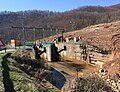 Bogatići Small Hydroelectric Power Station
 -
 Landscape from the area
 -
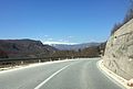 Road towardsTrnovo
 -
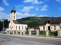 Serbian Orthodox church, built in the 19th century
 -
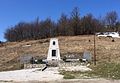 Monument dedicated to the Serb victims of the Bosnian war


References
[edit]- ^ "Naseljena Mjesta 1991/2013" (in Bosnian). Statistical Office of Bosnia and Herzegovina. Retrieved March 12, 2022.
- ^ "Naseljena Mjesta 1991/2013" (in Bosnian). Statistical Office of Bosnia and Herzegovina. Retrieved March 12, 2022.
- ^ Jahorina official website; accessed 13 December 2015.
- ^ Министарство управе и локалне самоуправе Републике Српске. "Уредба о насељеним мјестима која чине подручје јединице локалне самоуправе". Влада Републике Српске.
External links
[edit]
 | |||||||||||||||