
River Boyne: Difference between revisions
No edit summary Tags: Mobile edit Mobile web edit |
Citation bot (talk | contribs) Alter: template type. Add: newspaper. | Use this bot. Report bugs. | Suggested by Abductive | #UCB_webform 224/3850 |
||
| (35 intermediate revisions by 22 users not shown) | |||
| Line 1: | Line 1: | ||
{{ |
{{Short description|River in Leinster, Ireland}} |
||
{{ |
{{Redirect|Boyne Valley}} |
||
{{Use dmy dates|date=November 2019}} |
{{Use dmy dates|date=November 2019}} |
||
{{Use |
{{Use Hiberno-English|date=February 2023}} |
||
{{Infobox river |
{{Infobox river |
||
| name = River Boyne |
| name = River Boyne |
||
| |
| native_name ={{native name|ga|An Bhóinn}} |
||
| name_native_lang = ga |
|||
| name_other = {{ubl|{{native name|ga|An Bhóinn}} |{{native name|ga|Abhainn na Bóinne}}}} |
| name_other = {{ubl|{{native name|ga|An Bhóinn}} |{{native name|ga|Abhainn na Bóinne}}}} |
||
| name_etymology = [[Proto-Celtic]] *'' |
| name_etymology = [[Proto-Celtic]] *''bou-windā'', "white cow" |
||
<!---------------------- IMAGE & MAP --> |
<!---------------------- IMAGE & MAP --> |
||
| image = 20130808 bru na boinne07.JPG |
| image = 20130808 bru na boinne07.JPG |
||
| Line 21: | Line 20: | ||
<!---------------------- LOCATION --> |
<!---------------------- LOCATION --> |
||
| subdivision_type1 = Country |
| subdivision_type1 = Country |
||
| subdivision_name1 = [[Republic of Ireland]] |
| subdivision_name1 = [[Republic of Ireland|Ireland]] |
||
| subdivision_type2 = |
| subdivision_type2 = |
||
| subdivision_name2 = |
| subdivision_name2 = |
||
| Line 27: | Line 26: | ||
| subdivision_name3 = [[Leinster]] |
| subdivision_name3 = [[Leinster]] |
||
| subdivision_type4 = Counties |
| subdivision_type4 = Counties |
||
| subdivision_name4 = [[County Kildare]], [[County Offaly]], [[County Meath]], [[County Louth]] |
| subdivision_name4 = [[County Kildare|Kildare]], [[County Offaly|Offaly]], [[County Meath|Meath]], [[County Louth|Louth]] |
||
| subdivision_type5 = |
| subdivision_type5 = |
||
| subdivision_name5 = |
| subdivision_name5 = |
||
| Line 45: | Line 44: | ||
| source1 = Trinity Well, Newberry Hall, near [[Carbury, County Kildare|Carbury]] |
| source1 = Trinity Well, Newberry Hall, near [[Carbury, County Kildare|Carbury]] |
||
| source1_location = [[County Kildare]] |
| source1_location = [[County Kildare]] |
||
| source1_coordinates= |
| source1_coordinates= {{coord|53.351906542854074|-6.956809100021702}} |
||
| source1_elevation = |
| source1_elevation = |
||
| mouth = [[Irish Sea]] |
| mouth = [[Irish Sea]] |
||
| Line 61: | Line 60: | ||
}} |
}} |
||
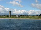
[[File:Boyne-Tal.jpg|right|thumb|300px|The River Boyne and Boyne Valley as seen from the [[Knowth]] [[passage tomb]] of [[Brú na Bóinne]].]] |
[[File:Boyne-Tal.jpg|right|thumb|300px|The River Boyne and Boyne Valley as seen from the [[Knowth]] [[passage tomb]] of [[Brú na Bóinne]].]] |
||
The '''River Boyne''' ({{lang-ga|An Bhóinn}} or ''Abhainn na Bóinne'') is a river in [[Leinster]], [[Republic of Ireland|Ireland]], the course of which is about {{convert|112|km|mi}} long. It rises at Trinity Well, Newberry Hall, near [[Carbury, County Kildare|Carbury]], [[County Kildare]], and flows towards the Northeast through [[County Meath]] to reach the [[Irish Sea]] between [[Mornington, County Meath]], and [[Baltray]], County Louth. |
The '''River Boyne''' ({{lang-ga|An Bhóinn}} or ''Abhainn na Bóinne'') is a river in [[Leinster]], [[Republic of Ireland|Ireland]], the course of which is about {{convert|112|km|mi}} long. It rises at [[Trinity Well]], Newberry Hall, near [[Carbury, County Kildare|Carbury]], [[County Kildare]], and flows towards the Northeast through [[County Meath]] to reach the [[Irish Sea]] between [[Mornington, County Meath]], and [[Baltray]], County Louth. |
||
== Names and etymology == |
|||
| ⚫ | |||
| ⚫ | This river has been known since ancient times. The Greek geographer [[Ptolemy]] drew a map of [[Ireland]] in the 2nd century which included the Boyne,<ref name=":0">{{Cite book|last=Holten|first=Anthony|title=The River Boyne Hidden Legacies, histories and lore explored on foot and by boat|year=2016|isbn=978-0-9569911-2-6|location=Ireland|pages=27–29}}</ref> which he called {{lang|grc|Βουουίνδα}} (''Bouwinda'') or {{lang|grc|Βουβίνδα}} (''Boubinda''), which in Celtic means "white cow" ({{lang-ga|bó fhionn}}). During the High Middle Ages, [[Giraldus Cambrensis]] called it the ''Boandus''. In [[Irish mythology]] it is said that the river was created by the [[goddess]] [[Boann]] and Boyne is an anglicised form of the name.<ref name=":0" /> In other legends, it was in this river where [[Fionn mac Cumhail]] captured Fiontán, the [[Salmon of Knowledge]]. The Meath section of the Boyne was also known as ''Smior Fionn Feidhlimthe''<ref>Dineen: Foclóir Gaedhilge agus Béarla, 1927 ("Smior" - pg 1067, Ed.1996)</ref> (the 'marrow of Fionn Feilim'). The tidal estuary of the Boyne, which extends inland as far as the confluence with the [[Mattock River]], 'the curly hole', had a number of names in Irish literature and was associated as a place of departure and arrival in the ancient legends and myths, such as The Tragedy of the Sons of Tuireann, Togail Bruidne Dá Derga, &c. In the [[Acallam na Senórach]] the estuary has the name ''Inber Bic Loingsigh'', abounding in ships. ''Inber Colpa'' or ''Inber Colptha'' was the principal name for the mouth of the Boyne in early medieval times. The townlands and civil parish of Colp, or Colpe on its southern shore preserve the name. It was associated in myth with Colpa of the Sword, a son of [[Míl Espáine]], in the [[Milesians (Irish)|Milesian]] origin of the Irish, who drowned in the attempt to land there and is by tradition buried in the ringfort behind Colpe church. An alternative [[Dindsenchas]] tradition associates the name with the Máta, a massive aquatic creature, which having been killed was dismembered at [[Brú na Bóinne]] was thrown in the Boyne. Its shinbone (colptha) reached the estuary giving name to Inber Colptha. |
||
| ⚫ | |||
== Course and geography == |
|||
| ⚫ | Despite its short course, the Boyne has historical, archaeological and mythical connotations. The [[Battle of the Boyne]], a major battle in [[History of Ireland|Irish history]], took place along the Boyne near [[Drogheda]] in 1690 during the [[Williamite war in Ireland]]. It passes through the ancient town of [[Trim, County Meath|Trim]], [[Trim Castle]], the [[Hill of Tara]] (the ancient capital of the High King of Ireland), [[Navan]], the Hill of [[Slane]], [[Brú na Bóinne]] (a complex of [[megalith]]ic monuments), [[Mellifont Abbey]], and the medieval town of [[Drogheda]]. In the Boyne Valley can also be found other historical and archaeological monuments, including Loughcrew, [[Kells, County Meath|Kells]], Celtic crosses, and castles. |
||
| ⚫ | The Boyne is lowland river, which is surrounded by the Boyne Valley. It is crossed just west of [[Drogheda]] by the [[Mary McAleese Boyne Valley Bridge]], which carries the [[M1 motorway (Republic of Ireland)|M1 motorway]], and by the [[Boyne Viaduct]], which carries the [[Dublin]]-[[Belfast]] railway line to the east. The [[catchment]] area of the River Boyne is 2,695 km<sup>2</sup>.<ref name="serbd">[http://www.serbd.com/MultiDownloads/Creport/Chapters/Physical%20Description%20Ch3.pdf South Eastern River Basin District Management System. Page 38]{{webarchive |url=https://web.archive.org/web/20160303222354/http://www.serbd.com/MultiDownloads/Creport/Chapters/Physical%20Description%20Ch3.pdf |date=2016-03-03 }}</ref> |
||
| ⚫ | |||
===Significance=== |
|||
| ⚫ | This river has been known since ancient times. The Greek geographer [[Ptolemy]] drew a map of Ireland in the 2nd century which included the Boyne,<ref name=":0">{{Cite book|last=Holten|first=Anthony|title=The River Boyne Hidden Legacies, histories and lore explored on foot and by boat |
||
| ⚫ | Despite its short course, the Boyne has historical, archaeological and mythical connotations. The [[Battle of the Boyne]], a major battle in [[History of Ireland|Irish history]], took place along the Boyne near [[Drogheda]] in 1690 during the [[Williamite war in Ireland]]. It passes through the ancient town of [[Trim, County Meath|Trim]], [[Trim Castle]], the [[Hill of Tara]] (the ancient capital of the High King of Ireland), [[Navan]], the Hill of [[Slane]], [[Brú na Bóinne]] (a complex of [[megalith]]ic monuments), [[Mellifont Abbey]], and the medieval town of [[Drogheda]]. In the Boyne Valley can also be found other historical and archaeological monuments, including Loughcrew, [[Kells, County Meath|Kells]], Celtic crosses, and castles. |
||
== |
== History == |
||
=== Boyne Canal === |
|||
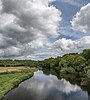
[[File:Channel of the Boyne - geograph.org.uk - 455524.jpg|right|thumb|200px|Section of the Boyne canal which runs parallel to the main river around the Battle of the Boyne site west of Drogheda.]] |
[[File:Channel of the Boyne - geograph.org.uk - 455524.jpg|right|thumb|200px|Section of the Boyne canal which runs parallel to the main river around the Battle of the Boyne site west of Drogheda.]] |
||
The [[Boyne Navigation]] is a series of canals running roughly parallel to the main river from [[Oldbridge]] near [[Drogheda]] to [[Navan]]. Owned by [[An Taisce]] and mostly derelict, the [[Inland Waterways Association of Ireland]] are restoring the navigation to navigable status. The canal at Oldbridge which runs through the battle of the Boyne Site was the first to be restored. |
The [[Boyne Navigation]] is a series of canals running roughly parallel to the main river from [[Oldbridge]] near [[Drogheda]] to [[Navan]]. Owned by [[An Taisce]] and mostly derelict, the [[Inland Waterways Association of Ireland]] are restoring the navigation to navigable status. The canal at Oldbridge which runs through the battle of the Boyne Site was the first to be restored. |
||
==Prehistoric art== |
=== Prehistoric art === |
||
A rock with indications of being [[Prehistoric art]] was found in August 2013. Cliadh O’Gibne |
A rock with indications of being [[Prehistoric art]] was found in August 2013. Cliadh O’Gibne reported through the [[Archaeological Survey of Ireland]] that a boulder with geometric carvings had been found in [[Donore, County Meath]].<ref>{{cite web|title=Newly Discovered Prehistoric Art in the Boyne Valley|url=http://www.archaeology.ie/News/Name,15142,en.html|work=National Monuments Service|access-date=30 November 2013|archive-date=27 November 2013|archive-url=https://web.archive.org/web/20131127185329/http://www.archaeology.ie/News/Name,15142,en.html|url-status=live}}</ref> |
||
==Ancient log-boat== |
=== Ancient log-boat === |
||
The Boyne Fishermen's Rescue and Recovery Service (BFRRS), near [[Drogheda]], [[County Louth]], were doing one of their regular operations to remove shopping trolleys from the Boyne, in May 2013, when they discovered an ancient log boat, which experts believe may be 5000 years old. Initial examination by an underwater archaeologist, suggests it could be very rare because, unlike other log-boats found here, it has oval shapes on the upper edge which could have held oars. Investigations were on-going as of 2013.<ref> |
The Boyne Fishermen's Rescue and Recovery Service (BFRRS), near [[Drogheda]], [[County Louth]], were doing one of their regular operations to remove shopping trolleys from the Boyne, in May 2013, when they discovered an ancient log boat, which experts believe may be 5000 years old. Initial examination by an underwater archaeologist, suggests it could be very rare because, unlike other log-boats found here, it has oval shapes on the upper edge which could have held oars. Investigations were on-going as of 2013.<ref>{{cite news |url=http://www.archaeology.org/news/867-130513-ireland-boyne-river-log-boat |title=Log Boat Found in Ireland's Boyne River |publisher=Archaeological Institute of America |newspaper=Archaeology |date=2013-05-13 |access-date=2017-06-02 |archive-date=2 November 2013 |archive-url=https://web.archive.org/web/20131102184634/http://www.archaeology.org/news/867-130513-ireland-boyne-river-log-boat |url-status=live }}</ref> |
||
{{cite news|url=http://www.archaeology.org/news/867-130513-ireland-boyne-river-log-boat |title=Log Boat Found in Ireland’s Boyne River |publisher=Archaeological Institute of America |newspaper=Archaeology |date=2013-05-13 |accessdate=2017-06-02}}</ref> |
|||
==Viking ship== |
=== Viking ship === |
||
In 2006, the remains of a Viking ship were found in the river bed in [[Drogheda]] during dredging operations. The vessel is to be excavated as it poses a hazard to navigation.<ref> |
In 2006, the remains of a Viking ship were found in the river bed in [[Drogheda]] during dredging operations. The vessel is to be excavated as it poses a hazard to navigation.<ref>{{Cite news |url=https://www.irishtimes.com/news/viking-ship-found-in-boyne-to-be-excavated-1.1291932 |title=Viking ship found in Boyne to be excavated |newspaper=[[The Irish Times]] |access-date=6 August 2019 |archive-date=4 December 2020 |archive-url=https://web.archive.org/web/20201204060502/https://www.irishtimes.com/news/viking-ship-found-in-boyne-to-be-excavated-1.1291932 |url-status=live }}</ref> |
||
==Annalistic references== |
===Annalistic references=== |
||
{{Further2|[[Annals of Inisfallen]] (AI)}} |
{{Further2|[[Annals of Inisfallen]] (AI)}} |
||
* AI770.2 The battle of Bolg Bóinne [gained] against the Uí Néill, by the Laigin. |
* AI770.2 The battle of Bolg Bóinne [gained] against the Uí Néill, by the Laigin. |
||
== Flora and fauna == |
|||
Various species of [[trout]] inhabit the Boyne, namely [[brook trout]], [[brown trout]] and introduced [[rainbow trout]]. There is also a [[steelhead]] in the spring and naturally reproducing [[salmon]] in the fall.<ref>{{cite web |title=Fish {{!}} The Friends of the Boyne River |url=https://boyneriver.org/fish/#:~:text=Brook%20Trout%2C%20Brown%20Trout%20and,reproducing%20salmon%20in%20the%20fall. |website=boyneriver.org |access-date=18 July 2022}}</ref> |
|||
==Gallery== |
==Gallery== |
||
{{gallery|mode=nolines|whitebg=y|height=100|align=center |
|||
File:Boyne Estuary.jpeg|Aerial view of the River Boyne estuary and Drogheda. |
|File:Boyne Estuary.jpeg|Aerial view of the River Boyne estuary and Drogheda. |
||
File: |
|File:Trim Castle November 2013.jpg|River Boyne at Trim. |
||
File:Poolboy Bridge, Navan - geograph.org.uk - 412366.jpg|River Boyne at Navan. |
|File:Poolboy Bridge, Navan - geograph.org.uk - 412366.jpg|River Boyne at Navan. |
||
File:Weir on Boyne Near Stackallen - geograph.org.uk - 397151.jpg|Weir on Boyne near Stackallen |
|File:Weir on Boyne Near Stackallen - geograph.org.uk - 397151.jpg|Weir on Boyne near Stackallen |
||
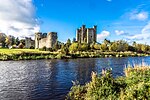
File:Dunmoe Castle - geograph.org.uk - 290230.jpg|River Boyne at Dunmoe Castle. |
|File:Dunmoe Castle - geograph.org.uk - 290230.jpg|River Boyne at Dunmoe Castle. |
||
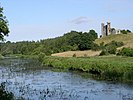
File:The Boyne Upstream of Slane Castle - geograph.org.uk - 499467.jpg|River Boyne upstream from Slane. |
|File:The Boyne Upstream of Slane Castle - geograph.org.uk - 499467.jpg|River Boyne upstream from Slane. |
||
File:The M1 Boyne Bridge, near Drogheda, Co. Louth - geograph.org.uk - 1414252.jpg|River Boyne passing under the Boyne Cable Bridge in Drogheda. |
|File:The M1 Boyne Bridge, near Drogheda, Co. Louth - geograph.org.uk - 1414252.jpg|River Boyne passing under the Boyne Cable Bridge in Drogheda. |
||
File:Boyne Viaduct - geograph.org.uk - 315651.jpg|Boyne Viaduct over the River Boyne. |
|File:Boyne Viaduct - geograph.org.uk - 315651.jpg|Boyne Viaduct over the River Boyne. |
||
File:Maiden Tower, Mornington, Co. Meath - geograph.org.uk - 907284.jpg|River Boyne at Mornington. |
|File:Maiden Tower, Mornington, Co. Meath - geograph.org.uk - 907284.jpg|River Boyne at Mornington. |
||
File:River Boyne (Abhainn na Bóinne) - Glebe, County Meath, Ireland - August 8, 2017 - 01.jpg|River Boyne at Brú na Bóinne. |
|File:River Boyne (Abhainn na Bóinne) - Glebe, County Meath, Ireland - August 8, 2017 - 01.jpg|River Boyne at Brú na Bóinne. |
||
File:River Boyne (Abhainn na Bóinne) - Glebe, County Meath, Ireland - August 8, 2017.jpg|River Boyne at Brú na Bóinne. |
|File:River Boyne (Abhainn na Bóinne) - Glebe, County Meath, Ireland - August 8, 2017.jpg|River Boyne at Brú na Bóinne. |
||
|File:Boyne Obelisk.jpg|Former [[Boyne Obelisk]], which stood on the north bank of the River Boyne (near Drogheda) from 1736 to 1923. |
|||
</gallery> |
|||
}} |
|||
==See also== |
==See also== |
||
* {{HMS|Boyne}} |
* {{HMS|Boyne}} |
||
* [[Anthony Holten]], author of ''The River Boyne: Hidden Legacies, History and Lore Explored on Foot and by Boat'' ({{ISBN|9780956991119}}) |
|||
==References== |
==References== |
||
{{ |
{{Reflist}} |
||
==External links== |
==External links== |
||
| Line 117: | Line 124: | ||
{{County Kildare}} |
{{County Kildare}} |
||
{{Rivers of Ireland}} |
{{Rivers of Ireland}} |
||
<!--{{coord|53|43|N|6|15|W|display=title|region:IE_type:river_source:GNS-enwiki}}--> |
<!--{{coord|53|43|N|6|15|W|display=title|region:IE_type:river_source:GNS-enwiki}}--> |
||
{{Authority control}} |
|||
[[Category:Rivers of County Kildare|Boyne]] |
[[Category:Rivers of County Kildare|Boyne]] |
||
Latest revision as of 15:17, 4 September 2023
| River Boyne | |
|---|---|
 River Boyne at Brú na Bóinne. | |
| Etymology | Proto-Celtic *bou-windā, "white cow" |
| Native name | An Bhóinn (Irish) |
| Location | |
| Country | Ireland |
| Region | Leinster |
| Counties | Kildare, Offaly, Meath, Louth |
| Physical characteristics | |
| Source | Trinity Well, Newberry Hall, near Carbury |
| • location | County Kildare |
| • coordinates | 53°21′07″N 6°57′25″W / 53.351906542854074°N 6.956809100021702°W |
| Mouth | Irish Sea |
• location | Between Mornington, County Meath and Baltray, County Louth |
• coordinates | 53°43′18″N 6°14′17″W / 53.72173°N 6.23813°W |
| Length | 112 km (70 mi) |
| Basin size | 2,695 km2 (1,041 sq mi) |
| Discharge | |
| • average | 38.8 m3/s (1,370 cu ft/s) |
| Basin features | |
| Tributaries | |
| • right | River Blackwater |

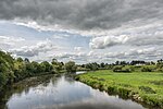
The River Boyne (Irish: An Bhóinn or Abhainn na Bóinne) is a river in Leinster, Ireland, the course of which is about 112 kilometres (70 mi) long. It rises at Trinity Well, Newberry Hall, near Carbury, County Kildare, and flows towards the Northeast through County Meath to reach the Irish Sea between Mornington, County Meath, and Baltray, County Louth.
Names and etymology
[edit]This river has been known since ancient times. The Greek geographer Ptolemy drew a map of Ireland in the 2nd century which included the Boyne,[1] which he called Βουουίνδα (Bouwinda) or Βουβίνδα (Boubinda), which in Celtic means "white cow" (Irish: bó fhionn). During the High Middle Ages, Giraldus Cambrensis called it the Boandus. In Irish mythology it is said that the river was created by the goddess Boann and Boyne is an anglicised form of the name.[1] In other legends, it was in this river where Fionn mac Cumhail captured Fiontán, the Salmon of Knowledge. The Meath section of the Boyne was also known as Smior Fionn Feidhlimthe[2] (the 'marrow of Fionn Feilim'). The tidal estuary of the Boyne, which extends inland as far as the confluence with the Mattock River, 'the curly hole', had a number of names in Irish literature and was associated as a place of departure and arrival in the ancient legends and myths, such as The Tragedy of the Sons of Tuireann, Togail Bruidne Dá Derga, &c. In the Acallam na Senórach the estuary has the name Inber Bic Loingsigh, abounding in ships. Inber Colpa or Inber Colptha was the principal name for the mouth of the Boyne in early medieval times. The townlands and civil parish of Colp, or Colpe on its southern shore preserve the name. It was associated in myth with Colpa of the Sword, a son of Míl Espáine, in the Milesian origin of the Irish, who drowned in the attempt to land there and is by tradition buried in the ringfort behind Colpe church. An alternative Dindsenchas tradition associates the name with the Máta, a massive aquatic creature, which having been killed was dismembered at Brú na Bóinne was thrown in the Boyne. Its shinbone (colptha) reached the estuary giving name to Inber Colptha.
Course and geography
[edit]The Boyne is lowland river, which is surrounded by the Boyne Valley. It is crossed just west of Drogheda by the Mary McAleese Boyne Valley Bridge, which carries the M1 motorway, and by the Boyne Viaduct, which carries the Dublin-Belfast railway line to the east. The catchment area of the River Boyne is 2,695 km2.[3] The long term average flow rate of the River Boyne is 38.8 cubic metres (50.7 cu yd) per second.[3]
Significance
[edit]Despite its short course, the Boyne has historical, archaeological and mythical connotations. The Battle of the Boyne, a major battle in Irish history, took place along the Boyne near Drogheda in 1690 during the Williamite war in Ireland. It passes through the ancient town of Trim, Trim Castle, the Hill of Tara (the ancient capital of the High King of Ireland), Navan, the Hill of Slane, Brú na Bóinne (a complex of megalithic monuments), Mellifont Abbey, and the medieval town of Drogheda. In the Boyne Valley can also be found other historical and archaeological monuments, including Loughcrew, Kells, Celtic crosses, and castles.
History
[edit]Boyne Canal
[edit]
The Boyne Navigation is a series of canals running roughly parallel to the main river from Oldbridge near Drogheda to Navan. Owned by An Taisce and mostly derelict, the Inland Waterways Association of Ireland are restoring the navigation to navigable status. The canal at Oldbridge which runs through the battle of the Boyne Site was the first to be restored.
Prehistoric art
[edit]A rock with indications of being Prehistoric art was found in August 2013. Cliadh O’Gibne reported through the Archaeological Survey of Ireland that a boulder with geometric carvings had been found in Donore, County Meath.[4]
Ancient log-boat
[edit]The Boyne Fishermen's Rescue and Recovery Service (BFRRS), near Drogheda, County Louth, were doing one of their regular operations to remove shopping trolleys from the Boyne, in May 2013, when they discovered an ancient log boat, which experts believe may be 5000 years old. Initial examination by an underwater archaeologist, suggests it could be very rare because, unlike other log-boats found here, it has oval shapes on the upper edge which could have held oars. Investigations were on-going as of 2013.[5]
Viking ship
[edit]In 2006, the remains of a Viking ship were found in the river bed in Drogheda during dredging operations. The vessel is to be excavated as it poses a hazard to navigation.[6]
Annalistic references
[edit]- AI770.2 The battle of Bolg Bóinne [gained] against the Uí Néill, by the Laigin.
Flora and fauna
[edit]Various species of trout inhabit the Boyne, namely brook trout, brown trout and introduced rainbow trout. There is also a steelhead in the spring and naturally reproducing salmon in the fall.[7]
Gallery
[edit]-
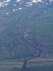 Aerial view of the River Boyne estuary and Drogheda.
 -
 River Boyne at Trim.
 -
 River Boyne at Navan.
 -
 Weir on Boyne near Stackallen
 -
 River Boyne at Dunmoe Castle.
 -
 River Boyne upstream from Slane.
 -
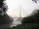 River Boyne passing under the Boyne Cable Bridge in Drogheda.
 -
 Boyne Viaduct over the River Boyne.
 -
 River Boyne at Mornington.
 -
 River Boyne at Brú na Bóinne.
 -
 River Boyne at Brú na Bóinne.
 -
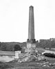 Former Boyne Obelisk, which stood on the north bank of the River Boyne (near Drogheda) from 1736 to 1923.


_-_Glebe,_County_Meath,_Ireland_-_August_8,_2017_-_01.jpg)
_-_Glebe,_County_Meath,_Ireland_-_August_8,_2017.jpg)

See also
[edit]- HMS Boyne
- Anthony Holten, author of The River Boyne: Hidden Legacies, History and Lore Explored on Foot and by Boat (ISBN 9780956991119)
References
[edit]- ^ a b Holten, Anthony (2016). The River Boyne Hidden Legacies, histories and lore explored on foot and by boat. Ireland. pp. 27–29. ISBN 978-0-9569911-2-6.
{{cite book}}: CS1 maint: location missing publisher (link) - ^ Dineen: Foclóir Gaedhilge agus Béarla, 1927 ("Smior" - pg 1067, Ed.1996)
- ^ a b South Eastern River Basin District Management System. Page 38Archived 2016-03-03 at the Wayback Machine
- ^ "Newly Discovered Prehistoric Art in the Boyne Valley". National Monuments Service. Archived from the original on 27 November 2013. Retrieved 30 November 2013.
- ^ "Log Boat Found in Ireland's Boyne River". Archaeology. Archaeological Institute of America. 13 May 2013. Archived from the original on 2 November 2013. Retrieved 2 June 2017.
- ^ "Viking ship found in Boyne to be excavated". The Irish Times. Archived from the original on 4 December 2020. Retrieved 6 August 2019.
- ^ "Fish | The Friends of the Boyne River". boyneriver.org. Retrieved 18 July 2022.
External links
[edit]- Salmon fishing on the River Boyne, from Salmon Ireland
- A canoeing and kayaking guide to the River Boyne, from Irish Whitewater

| International | |
|---|---|
| National | |
| Geographic | |