
Cholupice: Difference between revisions
No edit summary |
Moving {{Translated page}} to Talk:Cholupice per that template's documentation. If this bot is making errors, please report it at User:AnomieBOT/shutoff/TalkTemplateMover |
||
| (16 intermediate revisions by 15 users not shown) | |||
| Line 1: | Line 1: | ||
{{Infobox settlement |
|||
{{Geobox|Settlement |
|||
| name = Cholupice |
|||
<!-- *** Heading *** --> |
|||
| native_name = |
|||
| name = Cholupice |
|||
| other_name = |
|||
| native_name = |
|||
| settlement_type = Cadastral subdivision of Prague 12 |
|||
| other_name = |
|||
<!-- images, nickname, motto --> |
|||
| category = Cadastral subdivision of Prague 12 |
|||
| image_skyline = Prague Cholupice Common.jpg |
|||
<!-- *** Names **** --> |
|||
| image_caption = Village square |
|||
| etymology = |
|||
| image_flag = |
|||
| official_name = Cholupice |
|||
| image_shield = |
|||
| motto = |
|||
| motto = |
|||
| nickname = |
|||
| nickname = |
|||
<!-- *** Image *** --> |
|||
| etymology = |
|||
| image = Prague Cholupice Common.jpg |
|||
<!-- location --> |
|||
| image_caption = Village Square square in Cholupice |
|||
| subdivision_type = Country |
|||
| image_size = |
|||
| subdivision_name = Czech Republic |
|||
<!-- *** Symbols *** --> |
|||
| subdivision_type1 = |
|||
| flag = |
|||
| subdivision_name1 = |
|||
| symbol = |
|||
| subdivision_type2 = Region |
|||
<!-- *** Country *** --> |
|||
| subdivision_name2 = [[Prague]] |
|||
| country = Czech Republic |
|||
| subdivision_type3 = |
|||
| state = |
|||
| subdivision_name3 = |
|||
| region = [[Prague]], the Capital City |
|||
| subdivision_type4 = |
|||
| district = |
|||
| subdivision_name4 = |
|||
| municipality = |
|||
<!-- |
<!-- maps and coordinates --> |
||
| image_map = Praha KÚ Cholupice.png |
|||
| part = |
|||
| map_caption = Location of Cholupice in [[Prague]] |
|||
| landmark = |
|||
| pushpin_map = |
|||
| river = |
|||
| pushpin_relief = |
|||
<!-- *** Locations *** --> |
|||
| pushpin_map_caption = |
|||
| location = |
|||
| coordinates = {{coord|49|59|12|N|14|26|55|E|display=inline,title}} |
|||
| elevation = |
|||
| coordinates_footnotes = |
|||
| prominence = |
|||
<!-- established --> |
|||
| lat_d = 49 | lat_m = 59 | lat_s = 12 | lat_NS = N |
|||
| established_title = |
|||
| long_d = 14| long_m = 26 | long_s = 55| long_EW = E |
|||
| established_date = |
|||
| highest = |
|||
<!-- area --> |
|||
| highest_location = | highest_region = | highest_state = |
|||
| area_footnotes = |
|||
| highest_elevation = |
|||
| area_total_km2 = 6.39 |
|||
| highest_lat_d = | highest_lat_m = | highest_lat_s = | highest_lat_NS = |
|||
| area_total_sq_mi = |
|||
| highest_long_d = | highest_long_m = | highest_long_s = | highest_long_EW = |
|||
| area_land_sq_mi = |
|||
| lowest = |
|||
| area_water_sq_mi = |
|||
| lowest_location = | lowest_region = | lowest_state = |
|||
<!-- elevation --> |
|||
| lowest_elevation = |
|||
| elevation_footnotes = |
|||
| lowest_lat_d = | lowest_lat_m = | lowest_lat_s = | lowest_lat_NS = |
|||
| elevation_m = |
|||
| lowest_long_d = | lowest_long_m = | lowest_long_s = | lowest_long_EW = |
|||
| elevation_ft = |
|||
<!-- *** Dimensions *** --> |
|||
<!-- population --> |
|||
| length = | length_orientation = |
|||
| population_as_of = 31. 12. 2015<ref>{{Cite web | title = Obyvatelstvo a rozloha katastrálních území Prahy 2001–2015 | url = https://www.czso.cz/documents/11236/37543548/CR_L4_KU.xlsx | date = 2016-06-08 | publisher = Czech Statistical Office}}</ref> |
|||
| width = | width_orientation = |
|||
| population_footnotes = |
|||
| area = 6.39 |
|||
| population_total = 760 |
|||
| area_land = |
|||
| population_density_km2 = auto |
|||
| area_water = |
|||
| population_density_sq_mi= |
|||
| area_urban = |
|||
| population_demonym = |
|||
| area_metro = |
|||
<!-- |
<!-- time zone(s) --> |
||
| timezone1 = [[Central European Time|CET]] |
|||
| population = 760| population_date = 31. 12. 2015<ref>{{Citace elektronické monografie | title = Obyvatelstvo a rozloha katastrálních území Prahy 2001–2015 | url = https://www.czso.cz/documents/11236/37543548/CR_L4_KU.xlsx | date = 2016-06-08 | publisher = Czech Statistical Office}}</ref> |
|||
| utc_offset1 = +1 |
|||
| population_urban = |
|||
| timezone1_DST = [[Central European Summer Time|CEST]] |
|||
| population_metro = |
|||
| utc_offset1_DST = +2 |
|||
| population_density = auto |
|||
<!-- postal codes, area code --> |
|||
| population_density_urban = |
|||
| postal_code_type = Postal code |
|||
| population_density_metro = |
|||
| postal_code = 143 00 |
|||
<!-- *** History & management *** --> |
|||
| area_code_type = |
|||
| established = |
|||
| area_code = |
|||
| date = |
|||
| geocode = |
|||
| government = |
|||
| iso_code = |
|||
| government_location = | government_region = | government_state = |
|||
<!-- website, footnotes --> |
|||
| government_elevation = |
|||
| website = |
|||
| government_lat_d = | government_lat_m = | government_lat_s = | government_lat_NS = |
|||
| footnotes = |
|||
| government_long_d = | government_long_m = | government_long_s = | government_long_EW = |
|||
| mayor = |
|||
| leader = |
|||
<!-- *** Codes *** --> |
|||
| timezone = [[Central European Time|CET]] | utc_offset = +1 |
|||
| timezone_DST = [[Central European Summer Time|CEST]]| utc_offset_DST = +2 |
|||
| postal_code = 143 00 |
|||
| area_code = |
|||
| code = |
|||
<!-- *** UNESCO etc. *** --> |
|||
| whs_name = |
|||
| whs_year = |
|||
| whs_number = |
|||
| whs_region = |
|||
| whs_criteria = |
|||
| iucn_category = |
|||
<!-- *** Free fields *** --> |
|||
| free = | free_type = |
|||
<!-- *** Maps *** --> |
|||
| map = Praha KÚ Cholupice.png |
|||
| map_caption = Location of Cholupice in [[Prague]] |
|||
| map_background = |
|||
| map_locator = |
|||
<!-- *** Websites *** --> |
|||
| commons = |
|||
| statistics = |
|||
| website = |
|||
<!-- *** Footnotes *** --> |
|||
| footnotes = |
|||
}} |
}} |
||
'''Cholupice''' ({{lang-de|Cholupitz}}) a village in the south of [[Prague]] and a cadastral subdivision of [[Prague 12]]. There are 18 streets and 165 addresses registered, and a population of around 600. The [[D0 motorway (Czech Republic)|Outer Ring Road]] passes just south of the village, and to the south-west there is a [[Točná airport|recreational airport]]. The Cholupice Cemetery lies to the east. |
'''Cholupice''' ({{lang-de|Cholupitz}}) a village in the south of [[Prague]] and a cadastral subdivision of [[Prague 12]]. There are 18 streets and 165 addresses registered, and a population of around 600. The [[D0 motorway (Czech Republic)|Outer Ring Road]] passes just south of the village, and to the south-west there is a [[Točná airport|recreational airport]]. The Cholupice Cemetery lies to the east. |
||
Cholupice was, at one time, an independent municipality. The village of [[Točná]] was joined to Cholupice in 1960.<ref>M. Lašťovka, V. Ledvinka a kol.: ''Pražský uličník – Encyklopedie názvů pražských veřejných prostranství, 2. díl (O–Ž)'', Libri, Praha, 1998, p. 263, keyword „Točenská“</ref> The municipality of Cholupice, including Točná, was |
Cholupice was, at one time, an independent municipality. The village of [[Točná]] was joined to Cholupice in 1960.<ref>M. Lašťovka, V. Ledvinka a kol.: ''Pražský uličník – Encyklopedie názvů pražských veřejných prostranství, 2. díl (O–Ž)'', Libri, Praha, 1998, p. 263, keyword „Točenská“</ref> The municipality of Cholupice, including Točná, was amalgamated into the city of [[Prague]] in 1974. The local government in Cholupice was dissolved, and both villages were attached to the local government in [[Modřany]],<ref>Jan Mareš: [http://www.praha12.cz/doc/kronika/kronika_p12_1981_1985.pdf Praha 12-Modřany, Kronika, volební období 1981–1985]{{Dead link|date=July 2019 |bot=InternetArchiveBot |fix-attempted=yes }}, MNV Praha-Modřany, chapter Vývoj zemědělství v Modřanech, source: ''Pamětní kniha MNV Točná''</ref> which is now part of Prague 12. |
||
Every year on April 30, near ''Ke Kálku'' street at the eastern end of the village, Cholupice hosts Prague's largest symbolic [[ |
Every year on April 30, near ''Ke Kálku'' street at the eastern end of the village, Cholupice hosts Prague's largest symbolic [[Walpurgis Night|witch burning]] celebration. The village also has several clubs and [[Voluntary association|community associations]], including a volunteer fire brigade, a hunt club, an athletic club ''TJ Sokol Cholupice'', a branch of the Czech Husbandry Association ''Svaz Českých chovatelů'', a horse-riding club and a fishing club. On a Saturday in the second half of May, the village hosts a traditional [[Marzanna|Welcoming of Spring]] celebration ({{lang-cs|vítání jara}}), including the raising of a [[maypole]], and a parade through the village wearing [[folk costume]]s ({{lang-cs|kroj}}). |
||
==Photo gallery== |
|||
== Další fotografie == |
|||
<gallery> |
<gallery> |
||
Image:Prague Cholupice.jpg| Podchýšská Street, towards [[Písnice]] |
Image:Prague Cholupice.jpg| Podchýšská Street, towards [[Písnice]] |
||
| Line 110: | Line 82: | ||
== References == |
== References == |
||
{{Reflist}} |
|||
<references /> |
|||
*''This article was initially translated from the Czech Wikipedia.'' |
|||
{{Districts and cadastral areas of Prague}} |
{{Districts and cadastral areas of Prague}} |
||
{{Authority control}} |
|||
[[Category:Districts of Prague]] |
[[Category:Districts of Prague]] |
||
{{Prague-geo-stub}} |
|||
Latest revision as of 13:07, 28 July 2023
Cholupice | |
|---|---|
Cadastral subdivision of Prague 12 | |
 Village square | |
 Location of Cholupice in Prague | |
| Coordinates: 49°59′12″N 14°26′55″E / 49.98667°N 14.44861°E | |
| Country | Czech Republic |
| Region | Prague |
| Area | |
| • Total | 6.39 km2 (2.47 sq mi) |
| Population (31. 12. 2015[1]) | |
| • Total | 760 |
| • Density | 120/km2 (310/sq mi) |
| Time zone | UTC+1 (CET) |
| • Summer (DST) | UTC+2 (CEST) |
| Postal code | 143 00 |
Cholupice (German: Cholupitz) a village in the south of Prague and a cadastral subdivision of Prague 12. There are 18 streets and 165 addresses registered, and a population of around 600. The Outer Ring Road passes just south of the village, and to the south-west there is a recreational airport. The Cholupice Cemetery lies to the east.
Cholupice was, at one time, an independent municipality. The village of Točná was joined to Cholupice in 1960.[2] The municipality of Cholupice, including Točná, was amalgamated into the city of Prague in 1974. The local government in Cholupice was dissolved, and both villages were attached to the local government in Modřany,[3] which is now part of Prague 12.
Every year on April 30, near Ke Kálku street at the eastern end of the village, Cholupice hosts Prague's largest symbolic witch burning celebration. The village also has several clubs and community associations, including a volunteer fire brigade, a hunt club, an athletic club TJ Sokol Cholupice, a branch of the Czech Husbandry Association Svaz Českých chovatelů, a horse-riding club and a fishing club. On a Saturday in the second half of May, the village hosts a traditional Welcoming of Spring celebration (Czech: vítání jara), including the raising of a maypole, and a parade through the village wearing folk costumes (Czech: kroj).
Photo gallery
[edit]-
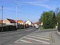 Podchýšská Street, towards Písnice
 -
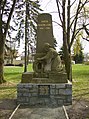 Memorial to the fallen of World War I
 -
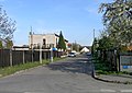 Lichá Street ("Odd Street") - there is no street in Prague named Sudá ("Even")


References
[edit]- ^ "Obyvatelstvo a rozloha katastrálních území Prahy 2001–2015". Czech Statistical Office. 2016-06-08.
- ^ M. Lašťovka, V. Ledvinka a kol.: Pražský uličník – Encyklopedie názvů pražských veřejných prostranství, 2. díl (O–Ž), Libri, Praha, 1998, p. 263, keyword „Točenská“
- ^ Jan Mareš: Praha 12-Modřany, Kronika, volební období 1981–1985[permanent dead link], MNV Praha-Modřany, chapter Vývoj zemědělství v Modřanech, source: Pamětní kniha MNV Točná
| Authority control databases: National |
|---|
This Prague location article is a stub. You can help Wikipedia by expanding it. |