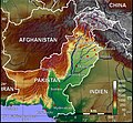
File:Paktopo de.jpg

Original file (1,187 × 1,102 pixels, file size: 1.28 MB, MIME type: image/jpeg)
Captions
Captions
| DescriptionPaktopo de.jpg | Topografische Karte Pakistans (deutschsprachige Version) |
| Date | |
| Source | Selbst erstellt mit Generic Mapping Tool |
| Author | BishkekRocks |
| Permission (Reusing this file) |
Unter GNU-FDL veröffentlicht |
| Other versions | Other language versions available upon request |
The map has been created with the Generic Mapping Tools: https://www.generic-mapping-tools.org/ using one or more of these public-domain datasets for the relief:
বাংলা ∙ English ∙ español ∙ français ∙ italiano ∙ 日本語 ∙ македонски ∙ sicilianu ∙ 中文(简体) ∙ 中文(繁體) ∙ +/− |

|
Permission is granted to copy, distribute and/or modify this document under the terms of the GNU Free Documentation License, Version 1.2 or any later version published by the Free Software Foundation; with no Invariant Sections, no Front-Cover Texts, and no Back-Cover Texts. A copy of the license is included in the section entitled GNU Free Documentation License.http://www.gnu.org/copyleft/fdl.htmlGFDLGNU Free Documentation Licensetruetrue |
| This file is licensed under the Creative Commons Attribution-Share Alike 3.0 Unported license. | ||
| ||
| This licensing tag was added to this file as part of the GFDL licensing update.http://creativecommons.org/licenses/by-sa/3.0/CC BY-SA 3.0Creative Commons Attribution-Share Alike 3.0truetrue |
File history
Click on a date/time to view the file as it appeared at that time.
| Date/Time | Thumbnail | Dimensions | User | Comment | |
|---|---|---|---|---|---|
| current | 16:38, 11 October 2006 |  | 1,187 × 1,102 (1.28 MB) | Jungpionier (talk | contribs) | besser so |
| 15:47, 11 October 2006 |  | 1,187 × 1,102 (307 KB) | Jungpionier (talk | contribs) | ein winziges kleines bisschen nachbearbeitet (rote Punkte außerhalb der Stadtmarkierungspunkte entfernt) | |
| 13:20, 11 October 2006 |  | 1,187 × 1,102 (684 KB) | BishkekRocks (talk | contribs) | {{Information |Description=Topografische Karte Pakistans (deutschsprachige Version) |Source=Selbst erstellt mit Generic Mapping Tool |Date=11. Oktober 2006 |Author=BishkekRocks |Permission=Unter GNU-FDL veröffentlicht }} {{GMT}} [[C |
You cannot overwrite this file.
File usage on Commons
The following 4 pages use this file:
File usage on other wikis
The following other wikis use this file:
- Usage on ace.wikipedia.org
- Usage on azb.wikipedia.org
- Usage on az.wikipedia.org
- Usage on be.wikipedia.org
- Usage on bg.wikipedia.org
- Usage on bs.wikipedia.org
- Usage on ca.wikipedia.org
- Usage on de.wikipedia.org
- Usage on diq.wikipedia.org
- Usage on en.wikipedia.org
- Usage on es.wikipedia.org
- Usage on fiu-vro.wikipedia.org
- Usage on frr.wikipedia.org
- Usage on fr.wikipedia.org
- Usage on hif.wikipedia.org
- Usage on hr.wikipedia.org
- Usage on incubator.wikimedia.org
- Usage on it.wikipedia.org
- Usage on kk.wikipedia.org
- Usage on lv.wikipedia.org
- Usage on pl.wikipedia.org
- Usage on pnb.wikipedia.org
- Usage on sd.wikipedia.org
- Usage on sh.wikipedia.org
- Usage on tr.wikipedia.org
- Usage on uk.wikipedia.org
- Usage on ur.wikipedia.org
Metadata
This file contains additional information such as Exif metadata which may have been added by the digital camera, scanner, or software program used to create or digitize it. If the file has been modified from its original state, some details such as the timestamp may not fully reflect those of the original file. The timestamp is only as accurate as the clock in the camera, and it may be completely wrong.
| _error | 0 |
|---|